
Hato Rey Sur facts for kids
Quick facts for kids
Hato Rey Sur
|
|
|---|---|

University Gardens on Calle Oxford
|
|

Hato Rey Sur
Location in Puerto Rico
|
|
| Commonwealth | |
| Municipality | |
| Area | |
| • Total | 0.82 sq mi (2.1 km2) |
| • Land | 0.82 sq mi (2.1 km2) |
| • Water | 0 sq mi (0 km2) |
| Elevation | 33 ft (10 m) |
| Population
(2020)
|
|
| • Total | 8,863 |
| • Density | 10,810/sq mi (4,173/km2) |
| Source: 2020 Census | |
| Time zone | UTC−4 (AST) |
Hato Rey Sur is a cool neighborhood, or "barrio," in San Juan, Puerto Rico. San Juan is the capital city of Puerto Rico. Hato Rey Sur is one of 18 barrios in San Juan.
Hato Rey Sur used to be part of a different town called Rio Piedras. But in 1951, Rio Piedras joined up with San Juan. This made San Juan much bigger, about four times its original size!
Contents
Who Lives in Hato Rey Sur?
| Historical population | |||
|---|---|---|---|
| Census | Pop. | %± | |
| 1950 | 14,908 | — | |
| 1960 | 11,947 | −19.9% | |
| 1970 | 13,687 | 14.6% | |
| 1980 | 12,642 | −7.6% | |
| 1990 | 12,915 | 2.2% | |
| 2000 | 10,868 | −15.8% | |
| 2010 | 10,738 | −1.2% | |
| 2020 | 8,863 | −17.5% | |
| U.S. Decennial Census 1900 (N/A) 1910-1930 1930-1950 1980-2000 2010 |
|||
In 2020, about 8,863 people lived in Hato Rey Sur. The number of people living there has changed over the years.
Smaller Neighborhoods Inside Hato Rey Sur
Hato Rey Sur is divided into four smaller areas called "subbarrios." Think of them like mini-neighborhoods within the bigger one.
- Bella Vista
- Hyde Park
- La 37
- Santa Rita
Cool Places to Visit in Hato Rey Sur
This barrio has some important and interesting spots:
- EDP University, Hato Rey Campus: A place where students go to learn and get a college education.
- Judicial Center of San Juan: This is where important legal decisions are made.
- Universidad Avenue: This street is super popular with college students. It's known for its fun nightlife and many places to eat.
- University of Puerto Rico's main campus: A very large university is also located nearby. Many students live in or near Hato Rey Sur.
Getting Around Hato Rey Sur
You can get around Hato Rey Sur using the Tren Urbano, which is San Juan's train system.
- The Piñero station is right in Hato Rey Sur.
- The Rio Piedras and Universidad stations are also very close by. They make it easy for people in Hato Rey Sur to travel.
Gallery
-
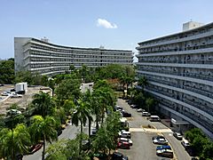
El Monte Condominium Towers are tall buildings where people live.
-
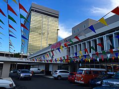
El Monte Mall is a shopping center where you can find stores and restaurants.
-
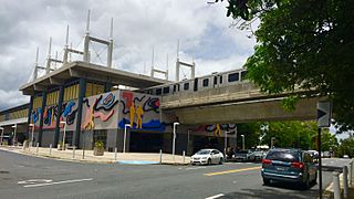
Piñero Station is a stop on the Tren Urbano, San Juan's train system.
.jpg)
.jpg)

See also
 In Spanish: Hato Rey Sur para niños
