
Hautapu River (Manawatū-Whanganui) facts for kids
Quick facts for kids Hautapu River |
|
|---|---|

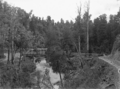
Bridge over the Hautapu River, 1906
|
|
| Physical characteristics | |
| Main source | Ngamatea Swamp |
| River mouth | Rangitikei River |
| Length | over 34 km (21 mi) |
The Hautapu River is a river in the Manawatū-Whanganui region of New Zealand. It starts in the Ngamatea Swamp, which is part of the New Zealand Army's training area near Waiouru.
From there, it flows south through farms. For some parts, it runs alongside State Highway 1. Finally, it joins the larger Rangitikei River south of Taihape. The river is more than 34 kilometers (21 miles) long.
River Features
The Hautapu River has a few waterfalls. In 1908, one waterfall was said to be about 4.5 meters (15 feet) high. However, old photos from that time suggest it might have been a bit smaller.
The North Island Main Trunk railway line follows the river closely for most of its journey. The railway crosses the river twice. In 1905, the river's path was changed a little. This was done so the railway wouldn't need to build two more bridges over it.
Fishing in the Hautapu River
The Hautapu River is a great spot for trout fishing. Many people enjoy coming here to catch fish.
Brown Trout Fishing
During the warmer summer months, you can find good-sized brown trout in the river. Anglers often try to catch these fish using special fishing methods. These methods include "dry-fly" fishing or "nymphing" techniques. In 1920, more brown trout were added to the river to help keep the fish population healthy.
Images for kids
-
Bridge over the Hautapu River, 1906
-
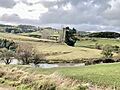
Turangarere Bridge, Hautapu River, where the railway makes a horseshoe curve

