
Hawaii water resource region facts for kids
The Hawaii water resource region is one of 21 big areas in the United States that helps us understand how water flows across the land. Think of it like a giant puzzle where each piece is a "water region." These regions are created by the United States Geological Survey (USGS) to help study and manage water.
Each water region includes all the land where rain and streams eventually flow into a main river or a group of rivers. The Hawaii region is special because it covers all the islands of Hawaii. It has a special code, 20, and is about 6,428 square miles (16,650 square kilometers) in size.
This big Hawaii region is then divided into 9 smaller parts called "subregions." Each subregion is like a smaller piece of the puzzle, focusing on the water flow around a specific island or group of islands.

Contents
Hawaii's Water Subregions
The Hawaii water resource region is split into nine main subregions. Each one focuses on the water systems of a particular island or group of islands. This helps scientists and water managers understand how water moves and collects in different parts of Hawaii.
Here's a look at each subregion:
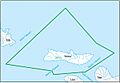
Hawaii Subregion (2001)
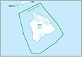
This subregion covers the largest island, Hawaii. It includes all the land where water drains on the island and the ocean waters around it. It's the biggest subregion, about 4,030 sq mi (10,400 km2).
Maui Subregion (2002)
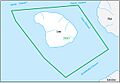
This area includes the island of Maui and its surrounding waters. It's about 730 sq mi (1,900 km2).
Kahoolawe Subregion (2003)
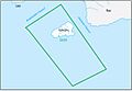
This subregion is for the island of Kahoolawe and its nearby waters. It's quite small, only about 45 sq mi (120 km2).
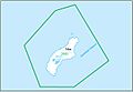
Lanai Subregion (2004)
This area covers the island of Lanai and the waters around it. It's about 140 sq mi (360 km2).
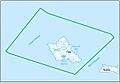
Molokai Subregion (2005)
This subregion includes the island of Molokai and its surrounding waters. It's about 260 sq mi (670 km2).
Oahu Subregion (2006)
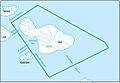
This area is for the island of Oahu, where the capital city Honolulu is located. It includes the island's drainage and nearby waters, covering about 630 sq mi (1,600 km2).
Kauai Subregion (2007)
This subregion covers the island of Kauai and its surrounding waters. It's about 560 sq mi (1,500 km2).
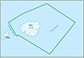
Niihau Subregion (2008)
This area includes the islands of Niihau and Kaula, along with their associated waters. It's about 72 sq mi (190 km2).
Northwestern Hawaiian Islands Subregion (2009)
This subregion covers many smaller islands, reefs, and islets far to the northwest of Niihau. These include Kure, Laysan, Lisianski, Necker, and Nihoa Islands, among others. This area is very small in land size, less than 10 sq mi (26 km2).
Images for kids
-
Map of the Hawaii subregion
-
Map of the Maui subregion
-
Map of the Kahoolawe subregion
-
Map of the Lanai subregion
-
Map of the Molokai subregion
-
Map of the Oahu subregion
-
Map of the Kauai subregion
-
Map of the Niihau subregion
-
Map of the Northwestern Hawaiian Islands subregion


