Hawthorn, Pennsylvania facts for kids
Quick facts for kids
Hawthorn, Pennsylvania
|
|
|---|---|
|
Borough
|
|

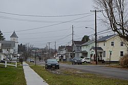
Houses on Main Street; the Methodist church is at left
|
|

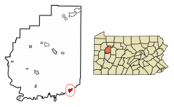
Location of Hawthorn in Clarion County, Pennsylvania.
|
|

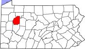
Map showing Clarion County in Pennsylvania
|
|
| Country | United States |
| State | Pennsylvania |
| County | Clarion |
| Incorporated | 1916 |
| Government | |
| • Type | Borough Council |
| Area | |
| • Total | 1.08 sq mi (2.81 km2) |
| • Land | 1.02 sq mi (2.65 km2) |
| • Water | 0.06 sq mi (0.15 km2) |
| Elevation | 1,105 ft (337 m) |
| Population
(2020)
|
|
| • Total | 477 |
| • Density | 465.37/sq mi (179.73/km2) |
| Time zone | UTC-5 (Eastern (EST)) |
| • Summer (DST) | UTC-4 (EDT) |
| ZIP code |
16230
|
| FIPS code | 42-33216 |
Hawthorn is a small town, also called a borough, located in Clarion County, Pennsylvania, in the United States. In 2020, about 482 people lived there. The town was officially formed in 1916.
Contents
Exploring Hawthorn's Location
Hawthorn is found in the southeastern part of Clarion County. It sits on the north side of Redbank Creek. This creek flows west and eventually joins the Allegheny River. Redbank Creek also forms the border between Hawthorn and Armstrong County to the south.
Roads and Travel in Hawthorn
Pennsylvania Route 28 is a main road that goes through Hawthorn. If you travel southwest on this road, you'll reach New Bethlehem in about 4 miles. Going northeast for about 9 miles will take you to Summerville.
Hawthorn's Size and Area
According to the United States Census Bureau, Hawthorn covers a total area of about 1.08 square miles (2.81 square kilometers). Most of this area, about 1.02 square miles (2.65 square kilometers), is land. The remaining part, about 0.06 square miles (0.15 square kilometers), is water, making up about 5.50% of the total area.
Hawthorn's Population Over Time
Hawthorn has seen its population change over many years. Here's a quick look at how many people have lived there during different census counts:
| Historical population | |||
|---|---|---|---|
| Census | Pop. | %± | |
| 1880 | 290 | — | |
| 1890 | 376 | 29.7% | |
| 1900 | 559 | 48.7% | |
| 1910 | 509 | −8.9% | |
| 1920 | 665 | 30.6% | |
| 1930 | 571 | −14.1% | |
| 1940 | 628 | 10.0% | |
| 1950 | 666 | 6.1% | |
| 1960 | 612 | −8.1% | |
| 1970 | 552 | −9.8% | |
| 1980 | 547 | −0.9% | |
| 1990 | 528 | −3.5% | |
| 2000 | 587 | 11.2% | |
| 2010 | 494 | −15.8% | |
| 2020 | 482 | −2.4% | |
| 2021 (est.) | 480 | −2.8% | |
| Sources: | |||
Understanding the 2000 Census Data
In the year 2000, the census showed that 587 people lived in Hawthorn. These people lived in 213 different homes, and 166 of these were families. On average, there were about 2.76 people living in each home.
Most of the people in Hawthorn were White (98.13%). A smaller number were African American (1.36%), or from other backgrounds. About 0.34% of the population identified as Hispanic or Latino.
Age Groups in Hawthorn
The population in 2000 was spread across different age groups:
- About 29.5% of the people were under 18 years old.
- About 7.7% were between 18 and 24 years old.
- About 25.0% were between 25 and 44 years old.
- About 23.5% were between 45 and 64 years old.
- About 14.3% were 65 years old or older.
The average age of people in Hawthorn was 34 years. For every 100 females, there were about 95 males.
Income and Financial Well-being
In 2000, the average yearly income for a household in Hawthorn was $26,771. For families, the average income was $29,545. The average income per person in the borough was $13,146.
About 16.5% of all people in Hawthorn lived below the poverty line. This included 26.4% of those under 18 years old.
Education in Hawthorn
Students in Hawthorn attend public schools that are part of the Redbank Valley School District.
See also
 In Spanish: Hawthorn (Pensilvania) para niños
 | Sharif Bey |
 | Hale Woodruff |
 | Richmond Barthé |
 | Purvis Young |


