
New Bethlehem, Pennsylvania facts for kids
Quick facts for kids
New Bethlehem, Pennsylvania
|
|
|---|---|
|
Borough
|
|
.jpg)
Building at the intersection of Broad Street (PA Route 28) and Wood Street (PA Route 66) looking east in downtown New Bethlehem
|
|

Location of New Bethlehem in Clarion County, Pennsylvania.
|
|

Map showing Clarion County in Pennsylvania
|
|

New Bethlehem, Pennsylvania
Location in Pennsylvania
|
|
| Country | United States |
| State | Pennsylvania |
| County | Clarion |
| Settled | 1840 |
| Incorporated | 1853 |
| Government | |
| • Type | Borough Council |
| Area | |
| • Total | 0.52 sq mi (1.34 km2) |
| • Land | 0.47 sq mi (1.21 km2) |
| • Water | 0.05 sq mi (0.13 km2) |
| Elevation | 1,070 ft (330 m) |
| Population
(2020)
|
|
| • Total | 978 |
| • Density | 2,098.71/sq mi (809.92/km2) |
| Time zone | UTC-5 (Eastern (EST)) |
| • Summer (DST) | UTC-4 (EDT) |
| ZIP code |
16242
|
| FIPS code | 42-53248 |

New Bethlehem (/nuːˈbɛθ.lʌm/ new-BETH-lum) is a small town, called a borough, in Clarion County, Pennsylvania, United States. In 2020, about 979 people lived there. The borough is located in the southwestern part of the beautiful Pennsylvania Wilds Conservation Landscape. Its main road, PA Route 28-66, is an important path connecting the Pittsburgh area with northcentral Pennsylvania. If you want to learn more about visiting Clarion County, you can check out Discover Clarion County.
Contents
Where is New Bethlehem Located?
New Bethlehem is found along the southern edge of Clarion County. It sits in the valley of Redbank Creek. This creek actually separates New Bethlehem from South Bethlehem, which is in Armstrong County to the south.
Main Roads in New Bethlehem
Pennsylvania Route 28 goes through the borough. It crosses Redbank Creek into South Bethlehem and then heads southwest about 20 miles to Kittanning. To the northeast, PA 28 leads about 20 miles to Brookville and Interstate 80.
Pennsylvania Route 66 meets PA 28 in the center of New Bethlehem. It goes north about 13 miles to I-80 and 16 miles to Clarion, which is the main town of the county. PA 66 also travels southwest with PA 28 to Kittanning. Another road, Pennsylvania Route 861, goes west from New Bethlehem about 12 miles to Rimersburg.
How Big is New Bethlehem?
The borough of New Bethlehem covers a total area of about 0.52 square miles (1.3 square kilometers). Most of this area, about 0.47 square miles (1.2 square kilometers), is land. The rest, about 0.05 square miles (0.1 square kilometers), is water.
A Look Back at New Bethlehem's History

One of the first important people to settle in the borough was Henry "Gum" Nolf. He built the first store, a mill for grinding grain, and a sawmill. Because of him, the town was first called "Gumtown." Later, it was named "Bethlehem." To make sure people didn't confuse it with Bethlehem, Pennsylvania, in the eastern part of the state, it was finally named "New Bethlehem."
Who Lives in New Bethlehem?
.jpg)
| Historical population | |||
|---|---|---|---|
| Census | Pop. | %± | |
| 1860 | 380 | — | |
| 1870 | 348 | −8.4% | |
| 1880 | 773 | 122.1% | |
| 1890 | 1,026 | 32.7% | |
| 1900 | 1,269 | 23.7% | |
| 1910 | 1,625 | 28.1% | |
| 1920 | 1,662 | 2.3% | |
| 1930 | 1,590 | −4.3% | |
| 1940 | 1,622 | 2.0% | |
| 1950 | 1,604 | −1.1% | |
| 1960 | 1,599 | −0.3% | |
| 1970 | 1,406 | −12.1% | |
| 1980 | 1,441 | 2.5% | |
| 1990 | 1,151 | −20.1% | |
| 2000 | 1,057 | −8.2% | |
| 2010 | 989 | −6.4% | |
| 2020 | 979 | −1.0% | |
| 2021 (est.) | 975 | −1.4% | |
| Sources: | |||
In 2000, there were 1,057 people living in New Bethlehem. There were 489 households, and 274 families. The population density was about 2,218 people per square mile. Most of the people living there were White (98.49%).
About 21.9% of households had children under 18. About 44% of households were married couples living together. The average household had 2.08 people, and the average family had 2.80 people.
The age of the population was spread out:
- 19.0% were under 18 years old.
- 6.8% were from 18 to 24 years old.
- 24.2% were from 25 to 44 years old.
- 23.8% were from 45 to 64 years old.
- 26.1% were 65 years or older.
The average age was 45 years.
The median income for a household was $25,069. For a family, it was $38,750. About 16.0% of the population lived below the poverty line. This included 20.0% of those under 18 and 9.4% of those 65 or older.
New Bethlehem's Peanut Butter Festival
New Bethlehem is famous for its yearly Peanut Butter Festival! In 2018, this festival celebrated its 23rd year. Even though the town has a Smucker's peanut butter factory, the company doesn't officially sponsor the festival.
However, Smucker's does sell peanut butter at the festival in many flavors, like Honey and Peanut Butter and Chocolate and Peanut Butter. In 2018, Smucker's also gave savings bonds to the winners of the Peanut Butter Festival Queen competition. The festival is organized by the Redbank Valley Chamber of Commerce and mainly takes place in Gumtown Park.
The Flood of 1996
On July 19, 1996, a big flood hit New Bethlehem and other parts of Pennsylvania. Reports said that the Redbank Creek rose more than seven feet above its normal level. A large part of the downtown area was underwater.
Redbank Valley High School had to close down. It took several months to clean up and fix the damage before students could return to school. On a garage east of the high school, you can still see a line that shows how high the water reached during the flood.
Redbank Valley Trail: A Path for Adventure

New Bethlehem is one of the towns that the Redbank Valley Trail goes through. This trail is 41 miles long! It starts at the Allegheny River and follows the Redbank Creek all the way to Brookville.
In 2014, the Pennsylvania Department of Conservation and Natural Resources chose it as the "Trail of the Year." The trail was built on an old railway line. The last train traveled through New Bethlehem on November 5, 2007, removing the tracks as it went towards Brookville. Now, it's a great place for walking, biking, and enjoying nature!
Education in New Bethlehem
New Bethlehem is home to the Redbank Valley School District. Two of the district's school buildings are located within the borough limits: Redbank Valley Junior/Senior High School and Redbank Valley Primary School. The borough also has baseball, football, and soccer fields for the schools.
The district's third school building, Redbank Valley Intermediate School, is located in Hawthorn, PA.
Famous People from New Bethlehem
- Ossee Schreckengost - A Baseball player who was born in New Bethlehem in 1875.
Images for kids
-
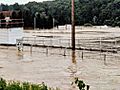
The football field at Redbank Valley Junior/Senior High School in July 1996 during the flood.
-
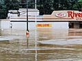
Tom's Riverside, a grocery store in New Bethlehem, PA, during the July 1996 flooding.
-
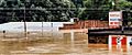
Flooding along east Broad Street in New Bethlehem, PA, in July 1996.


See also
 In Spanish: New Bethlehem para niños
