
Hemmental facts for kids
Quick facts for kids
Hemmental
|
||
|---|---|---|

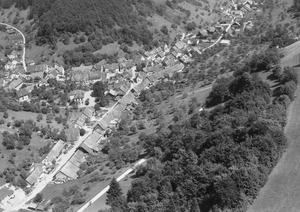
Hemmental village
|
||
|
||

Hemmental
Location in Switzerland

Hemmental
Location in Canton of Schaffhausen
|
||
| Country | Switzerland | |
| Canton | Schaffhausen | |
| District | n.a. | |
| Area | ||
| • Total | 10.78 km2 (4.16 sq mi) | |
| Elevation | 588 m (1,929 ft) | |
| Population | ||
| • Total | 542 | |
| • Density | 50.28/km2 (130.22/sq mi) | |
| Postal code |
8231
|
|
| Surrounded by | Beggingen, Beringen, Merishausen, Schleitheim, Schaffhausen, Siblingen | |

Hemmental was once a small town, called a municipality, in the canton of Schaffhausen in Switzerland. In 2009, Hemmental joined with the larger city of Schaffhausen.
Hemmental was located about 4.5 kilometers (2.8 miles) from Schaffhausen city. It was also about 7 kilometers (4.3 miles) from the Schaffhausen train station.
First Settlers
Most historians believe that people first settled in Hemmental between the 7th and 8th centuries. These early settlers were likely the Alemans, a Germanic tribe.
Local stories say the village got its name from a Germanic priest named Hemo. Records from Burkhard of Nellenburg show that in 1090, Hemo gave Hemmental to the Abbey of Allerheiligen in Schaffhausen. He also gave them nearby Buesingen and Berslingen. At that time, about 30 families might have lived in Hemmental.
Important Families
In 1483, the name "Schlatter" first appeared in Hemmental. Soon after, the names "Mettler," "Hatt," and "Leu" also became common. These families became very important in the area.
Today, you can still find four places named after them: Schlatter, Leuen, Hatten, and Mettlerhof. Three of these family names are still common in Hemmental. The Mettler name is no longer found there.
In 1951, these four important family names inspired a new village coat of arms. It features four golden stars on a blue and red shield. The official description, or blazon, of the coat of arms is Per saltire Gules and Azure in each a Mullet Or.
Geography
Hemmental had an area of about 10.9 square kilometers (4.2 square miles) in 2006. A large part of this land, about 70.3%, was covered by forests. About 26.6% of the land was used for farming. The remaining 3% was where buildings and roads were located.
Hemmental was a farming village. It was located at the bottom of the Randen range of hills.
Population Changes
The number of people living in Hemmental changed over many years. Here is a look at how the population grew and shrank:
| Year | Population |
|---|---|
| 1771 | 241 |
| 1798 | 305 |
| 1836 | 372 |
| 1850 | 409 |
| 1900 | 496 |
| 1950 | 409 |
| 2000 | 513 |
See also
 In Spanish: Hemmental para niños
