Henwood Down facts for kids
Quick facts for kids Henwood Down |
|
|---|---|

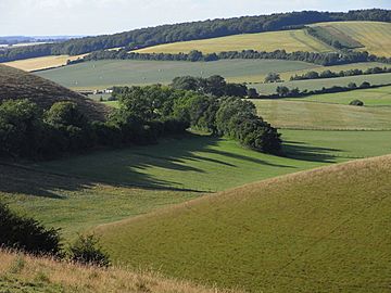
Downland above Coombe, East Meon, with Henwood Down behind.
|
|
| Highest point | |
| Elevation | 201 m (659 ft) |
| Prominence | 64 m (210 ft) |
| Parent peak | Butser Hill |
| Listing | Tump |
| Geography | |
| Location | Hampshire, England |
| Parent range | South Downs |
| OS grid | SU661219 |
| Topo map | OS Landranger |
Henwood Down is a notable hill located in Hampshire, England. It is one of the highest points in the county and a part of the beautiful South Downs area.
This hill reaches a height of 201 meters (about 660 feet) above sea level. It stands out quite a bit from the land around it, by 64 meters. Because of this, it is known as a Tump. A Tump is a hill that has a certain amount of prominence, meaning it rises clearly above the surrounding land.
Where is Henwood Down?
Henwood Down is found about 1 mile (1.6 kilometers) west of the village of East Meon in Hampshire. It is also located around 2 kilometers northeast of another interesting spot called Old Winchester Hill.
What Does it Look Like?
The northern side of Henwood Down is covered by a mixed forest, which is known as 'Hen Wood'. This area is full of trees and plants. However, the southern side of the hill is open land, offering wide views of the countryside.
A famous long-distance walking path, the South Downs Way, crosses over the southern part of the hill. This path is very popular with hikers and offers amazing scenery.
The hill is also part of a geological feature called the 'Winchester-East Meon Anticline'. This means the layers of rock under the hill are folded upwards, like a giant arch.
 | Ernest Everett Just |
 | Mary Jackson |
 | Emmett Chappelle |
 | Marie Maynard Daly |

