Hepburn, Iowa facts for kids
Quick facts for kids
Hepburn, Iowa
|
|
|---|---|
 |
|

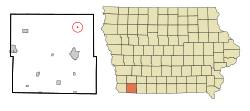
Location of Hepburn, Iowa
|
|
| Country | |
| State | |
| County | Page |
| Area | |
| • Total | 0.08 sq mi (0.21 km2) |
| • Land | 0.08 sq mi (0.21 km2) |
| • Water | 0.00 sq mi (0.00 km2) |
| Elevation | 1,050 ft (320 m) |
| Population
(2020)
|
|
| • Total | 26 |
| • Density | 317.07/sq mi (121.94/km2) |
| Time zone | UTC-6 (Central (CST)) |
| • Summer (DST) | UTC-5 (CDT) |
| ZIP code |
51632
|
| Area code(s) | 712 |
| FIPS code | 19-35760 |
| GNIS feature ID | 2394356 |
Hepburn is a small city located in Page County, Iowa, in the United States. It's a quiet place with a small number of residents. According to the 2020 census, only 26 people lived there.
Contents
History of Hepburn
Hepburn was officially planned and marked out in 1873. This process is called platting. A post office was also opened in the same year, making it easier for people to send and receive mail.
The city was named after William Peter Hepburn. He was an important person from nearby Clarinda, Iowa. William Hepburn was a veteran of the American Civil War, where he served as a Lieutenant Colonel. After the war, he became a well-known Congressman and a strong supporter of President Theodore Roosevelt.
Hepburn also had a train station, or depot, on the Chicago, Burlington and Quincy Railroad line. This would have been important for travel and trade in the early days.
Geography of Hepburn
Hepburn is a very small city in terms of its size. The United States Census Bureau reports that the city covers a total area of about 0.08 square miles (0.21 square kilometers). All of this area is land, meaning there are no lakes or large rivers within the city limits.
Population and People of Hepburn
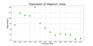
The number of people living in Hepburn has changed over the years. Like many small towns, its population has gone up and down.
| Historical populations | ||
|---|---|---|
| Year | Pop. | ±% |
| 1890 | 75 | — |
| 1900 | 118 | +57.3% |
| 1910 | 110 | −6.8% |
| 1920 | 108 | −1.8% |
| 1930 | 140 | +29.6% |
| 1940 | 81 | −42.1% |
| 1950 | 64 | −21.0% |
| 1960 | 49 | −23.4% |
| 1970 | 38 | −22.4% |
| 1980 | 42 | +10.5% |
| 1990 | 41 | −2.4% |
| 2000 | 39 | −4.9% |
| 2010 | 23 | −41.0% |
| 2020 | 26 | +13.0% |
| Source: and Iowa Data Center Source: |
||
2020 Population Details
In 2020, the city had 26 residents living in 8 households. All 8 of these households were considered families. The city's population density was about 315.8 people per square mile. Most of the people living in Hepburn were White.
About 62.5% of the households had children under 18 living with them. Half of the households were married couples. The median age in Hepburn was 46.5 years. This means half the people were younger than 46.5 and half were older. About 15.4% of residents were under 20 years old.
2010 Population Details
Back in 2010, there were 23 people living in Hepburn. They lived in 8 households, with 7 of these being families. The population density was about 287.5 people per square mile. All the residents were White.
Half of the households had children under 18. Most households (87.5%) were married couples living together. The median age was 35.5 years. About 34.8% of the residents were under 18 years old.
Education in Hepburn
Students living in Hepburn attend schools that are part of the Clarinda Community School District. This district provides education for children from Hepburn and surrounding areas.
Transportation in Hepburn
Hepburn does not have its own public bus system. However, for longer trips, people can use intercity bus services like Jefferson Lines. These services are available in Clarinda, which is a nearby city.
See also
 In Spanish: Hepburn (Iowa) para niños
 | Georgia Louise Harris Brown |
 | Julian Abele |
 | Norma Merrick Sklarek |
 | William Sidney Pittman |


