kids encyclopedia robot

Hi-Nella, New Jersey facts for kids

Kids Encyclopedia Facts
Quick facts for kids
Hi-Nella, New Jersey
Borough
Borough of Hi-Nella
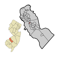
Hi-Nella highlighted in Camden County. Inset: Location of Camden County highlighted in the State of New Jersey.
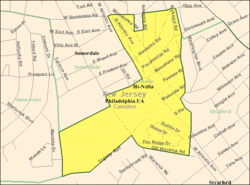
Census Bureau map of Hi-Nella, New Jersey
Country  United States
State  New Jersey
County Camden
Incorporated April 23, 1929
Government
 • Type Borough
 • Body Borough Council
Area
 • Total 0.22 sq mi (0.58 km2)
 • Land 0.22 sq mi (0.58 km2)
 • Water 0.00 sq mi (0.00 km2)  0.00%
Area rank 558th of 565 in state
35th of 37 in county
Elevation
62 ft (19 m)
Population
 • Total 870
 • Estimate 
(2019)
858
 • Rank 539th of 566 in state
35th of 37 in county
 • Density 3,773.3/sq mi (1,456.9/km2)
 • Density rank 167th of 566 in state
21st of 37 in county
Time zone UTC−05:00 (Eastern (EST))
 • Summer (DST) UTC−04:00 (Eastern (EDT))
ZIP Code
08083 - Somerdale
Area code(s) 856
FIPS code 3400732220
GNIS feature ID 0885256

Hi-Nella is a borough in Camden County, New Jersey, United States. As of the 2010 United States Census, the borough's population was 870, reflecting a decline of 159 (-15.5%) from the 1,029 counted in the 2000 Census, which had in turn declined by 16 (-1.5%) from the 1,045 counted in the 1990 Census. The borough is the state's ninth-smallest municipality.

The Borough of Hi-Nella was created on April 23, 1929, from portions of Clementon Township, as one of seven municipalities created from the now-defunct township, and one of five new municipalities (joining Lindenwold, Pine Hill, Pine Valley and Somerdale) created on that same date. The borough's name is traditionally said to derive from a Native American term meaning "high rolling knoll" or "high ground", though it may have been named for Nella, the wife of Lucious Parker, who developed Hi-Nella Estates in the late 1920s.

The Star-Ledger included Hi-Nella in its 2010 series of articles covering "Towns that Shouldn't Exist", citing the borough's small area, population and staff, along with its use of a double-wide trailer as a municipal building. Mayor Meredith Dobbs told The Star-Ledger that efforts to force the borough to consolidate with its neighbors would be "declared dead on arrival".

The borough had the fifth-highest property tax rate in New Jersey, with an equalized rate of 5.306% in 2020, compared to 3.470% in the county as a whole and a statewide average of 2.279%.

Geography

According to the United States Census Bureau, Hi-Nella borough had a total area of 0.231 square miles (0.597 km2), all of which was land.

Hi-Nella borders the Camden County municipalities of Gloucester Township, Somerdale and Stratford.

Demographics

Historical population
Census Pop.
1930 160
1940 203 26.9%
1950 237 16.7%
1960 474 100.0%
1970 1,195 152.1%
1980 1,250 4.6%
1990 1,045 −16.4%
2000 1,029 −1.5%
2010 870 −15.5%
2019 (est.) 858 −1.4%
Population sources:
1930-2000 1930
1930-1990 2000 2010

Census 2010

As of the census of 2010, there were 870 people, 377 households, and 216 families residing in the borough. The population density was 3,773.3 per square mile (1,456.9/km2). There were 420 housing units at an average density of 1,821.6 per square mile (703.3/km2)*. The racial makeup of the borough was 71.72% (624) White, 15.06% (131) Black or African American, 0.69% (6) Native American, 4.02% (35) Asian, 0.00% (0) Pacific Islander, 5.63% (49) from other races, and 2.87% (25) from two or more races. [[Hispanic (U.S. Census)|Hispanic or Latino of any race were 10.57% (92) of the population.

There were 377 households out of which 26.5% had children under the age of 18 living with them, 32.6% were married couples living together, 18.3% had a female householder with no husband present, and 42.7% were non-families. 31.8% of all households were made up of individuals, and 6.1% had someone living alone who was 65 years of age or older. The average household size was 2.31 and the average family size was 2.97.

In the borough, the population was spread out with 20.2% under the age of 18, 13.9% from 18 to 24, 28.7% from 25 to 44, 27.8% from 45 to 64, and 9.3% who were 65 years of age or older. The median age was 34.2 years. For every 100 females there were 89.1 males. For every 100 females ages 18 and old there were 86.6 males.

The Census Bureau's 2006-2010 American Community Survey showed that (in 2010 inflation-adjusted dollars) median household income was $45,469 (with a margin of error of +/- $4,794) and the median family income was $53,750 (+/- $15,403). Males had a median income of $37,222 (+/- $14,117) versus $38,804 (+/- $7,870) for females. The per capita income for the borough was $23,678 (+/- $3,470). About 13.5% of families and 13.7% of the population were below the poverty line, including 26.0% of those under age 18 and 5.9% of those age 65 or over.

Census 2000

As of the 2000 United States Census there were 1,029 people, 472 households, and 260 families residing in the borough. The population density was 4,536.9 people per square mile (1,727.4/km2). There were 495 housing units at an average density of 2,182.5 per square mile (831.0/km2). The racial makeup of the borough was 71.04% White, 19.24% African American, 3.11% Asian, 4.37% from other races, and 2.24% from two or more races. Hispanic or Latino of any race were 6.90% of the population.

There were 472 households, out of which 28.0% had children under the age of 18 living with them, 31.6% were married couples living together, 16.3% had a female householder with no husband present, and 44.9% were non-families. 36.4% of all households were made up of individuals, and 9.3% had someone living alone who was 65 years of age or older. The average household size was 2.18 and the average family size was 2.83.

In the borough the population was spread out, with 25.0% under the age of 18, 10.5% from 18 to 24, 36.3% from 25 to 44, 14.5% from 45 to 64, and 13.7% who were 65 years of age or older. The median age was 32 years. For every 100 females, there were 89.2 males. For every 100 females age 18 and over, there were 87.8 males.

The median income for a household in the borough was $34,948, and the median income for a family was $38,393. Males had a median income of $32,308 versus $25,759 for females. The per capita income for the borough was $19,285. About 9.9% of families and 12.2% of the population were below the poverty line, including 10.7% of those under age 18 and 6.3% of those age 65 or over.

Transportation

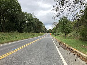
2018-10-09 12 15 18 View north along Camden County Route 727 (Atlantic Avenue) just north of Minnetonka Road in Hi-Nella, Camden County, New Jersey
County Route 727 northbound entering Hi-Nella

As of May 2010, the borough had a total of 3.18 miles (5.12 km) of roadways, of which 2.32 miles (3.73 km) were maintained by the municipality and 0.86 miles (1.38 km) by Camden County.

No Interstate, U.S., state or major county highways traverse Hi-Nella. The only numbered routes are minor county roads, such as County Route 727.

Education

Hi-Nella is a non-operating school district. For pre-kindergarten through eighth grade, public school students from Hi-Nella attend school in Stratford as part of a sending/receiving relationship with the Stratford School District that was phased in over a five-year period starting in 2012–13. As of the 2018–19 school year, the district, comprised of two schools, had an enrollment of 862 students and 69.1 classroom teachers (on an FTE basis), for a student–teacher ratio of 12.5:1. Schools in the district (with 2018–19 enrollment data from the National Center for Education Statistics) are Parkview Elementary School with 367 students in pre-kindergarten through third grade and Samuel S. Yellin Elementary School with 487 students in grades 4 - 8.

Prior to the 2012-13 changeover, Hi-Nella students in K-8 had attended the Oaklyn Public School District. With Hi-Nella ending its sending/receiving relationship under a phase-out that would see all Hi-Nella students out of Oaklyn's school by 2016–17, the Oaklyn district saw overall enrollment decline from 469 in 2011–12 to 384 in 2014–15, resulting in the loss of tuition revenue that had accounted for as much as 10% of Oaklyn's budget, causing significant strain on the district's budget.

For ninth grade through twelfth grade, public school students attend Sterling High School, a regional high school district that serves students from Magnolia, Somerdale and Stratford, along with the sending districts of Hi-Nella and Laurel Springs. The high school is located in Somerdale. As of the 2018–19 school year, the high school had an enrollment of 958 students and 69.8 classroom teachers (on an FTE basis), for a student–teacher ratio of 13.7:1.

Prior to the establishment of this agreement with Sterling in 2012, Hi-Nella students attended Collingswood High School, which is much further away from Hi-Nella.

See also

Kids robot.svg In Spanish: Hi-Nella para niños

kids search engine
Hi-Nella, New Jersey Facts for Kids. Kiddle Encyclopedia.