Hill 'n Dale, Florida facts for kids
Quick facts for kids
Hill 'n Dale, Florida
|
|
|---|---|

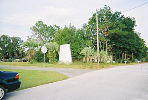
The faded sign that used to greet residents of and visitors to Hill 'n Dale
|
|

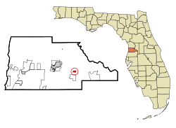
Location in Hernando County and the state of Florida
|
|
| Country | United States |
| State | Florida |
| County | Hernando |
| Area | |
| • Total | 2.20 sq mi (5.70 km2) |
| • Land | 2.20 sq mi (5.69 km2) |
| • Water | 0.00 sq mi (0.00 km2) |
| Elevation | 108 ft (33 m) |
| Population
(2020)
|
|
| • Total | 2,212 |
| • Density | 1,005.91/sq mi (388.47/km2) |
| Time zone | UTC-5 (Eastern (EST)) |
| • Summer (DST) | UTC-4 (EDT) |
| FIPS code | 12-30800 |
| GNIS feature ID | 0300931 |
Hill 'n Dale is a special kind of community in Hernando County, Florida, United States. It's called a census-designated place (CDP). This means it's an area that the government tracks for population and other facts, even though it's not officially a city or town.
In 2020, about 2,212 people lived in Hill 'n Dale. It's a small but interesting place in the Sunshine State!
Contents
Where is Hill 'n Dale Located?
Hill 'n Dale is found in the eastern part of Hernando County. You can find its exact spot using coordinates: 28°31′26″N 82°17′38″W / 28.52389°N 82.29389°W.
The community is located along U.S. Route 98. This main road helps people travel to and from Hill 'n Dale. The older part of the community is north of this highway. However, the area officially recognized as Hill 'n Dale grew in 2010 to include some land south of the highway too.
Traveling from Hill 'n Dale
From Hill 'n Dale, you can easily reach other places.
- If you go west on US 98 for about 6 miles (10 km), you'll arrive in Brooksville. This is the county seat, which means it's where the main government offices for Hernando County are located.
- Heading east on US 98 for about 3.5 miles (5.6 km) leads to Interstate 75. If you continue about 7 miles (11 km) east, you'll reach Ridge Manor.
- Hill 'n Dale is also about 44 miles (71 km) north of Tampa.
- It's about 56 miles (90 km) south of Ocala.
Size of the Area
The United States Census Bureau says that Hill 'n Dale covers a total area of about 2.2 square miles (5.7 square kilometers). All of this area is land, meaning there are no large lakes or rivers within its borders.
Who Lives in Hill 'n Dale?
The census helps us understand the people who live in a place.
| Historical population | |||
|---|---|---|---|
| Census | Pop. | %± | |
| 2020 | 2,212 | — | |
| U.S. Decennial Census | |||
In 2000, there were 1,436 people living in Hill 'n Dale. These people lived in 463 households, which are like homes or apartments. About 368 of these households were families.
The population density was about 2,823 people per square mile (1,090 people per square kilometer). This tells us how many people live in a certain amount of space. There were also 511 housing units, like houses or apartments, in the area.
Families and Age Groups
Many households in Hill 'n Dale had children. In 2000, about 47.3% of households had kids under 18 living there. About half of the households (49.5%) were married couples living together.
The average household had about 3.10 people. The average family had about 3.43 people.
The population of Hill 'n Dale includes people of all ages:
- About 36.4% of the people were under 18 years old.
- About 9.9% were between 18 and 24 years old.
- About 26.8% were between 25 and 44 years old.
- About 17.4% were between 45 and 64 years old.
- About 9.5% were 65 years old or older.
The median age in Hill 'n Dale was 28 years old. This means half the people were younger than 28, and half were older.
See also
In Spanish: Hill 'n Dale para niños
 | Kyle Baker |
 | Joseph Yoakum |
 | Laura Wheeler Waring |
 | Henry Ossawa Tanner |

