
Hilltop (Columbus, Ohio) facts for kids
Quick facts for kids
Hilltop, Columbus
|
|
|---|---|
|
Neighborhood of Columbus
|
|

Hilltop, USA sign welcoming visitors to area
|
|
| Country | United States |
| State | Ohio |
| County | Franklin |
| City | Columbus |
Hilltop is a big and interesting neighborhood in Columbus, Ohio. It's located west of Franklinton and Downtown Columbus. The Hilltop area has a mix of old and new homes, schools, shops, and fun places to visit. Most of the homes here are single-family houses.
Contents
Hilltop's History


How Hilltop Got Its Name
The name "Hilltop" comes from Lucas Sullivant, who first owned this land. For a while, people called the area "Sullivant's Hill." Later, as the land changed owners, the name became "Hilltop." Since the area is made up of many smaller neighborhoods, some people call it "Greater Hilltop." But "Hilltop" is the name that brings them all together.
Early Days of Hilltop
The first people to live here were Native Americans. You can still find traces of them in the area. This spot was important because of its hill and rich farmland.
Lucas Sullivant arrived in 1795 and was the first person to officially own land here. He lived in the Franklinton area but gave 1600 acres of land to his sons. This made them the first landowners in Hilltop. The land stayed in their family for over a hundred years.
For a long time, Hilltop was mostly farmland. Farmers grew corn, clover, and hay, and raised animals. A big change came with the National Road, also known as Route 40. This road was built in the 1830s and became home to places like the Four-Mile House and the Jaybird Hotel.
One very important place from this time was Camp Chase. During the Civil War, it was a training ground for the Union army. It was also the biggest prisoner camp in the North, holding over 9,000 prisoners in 1865. After the war, a small part of the camp became a cemetery and memorial for Confederate soldiers.
Hilltop in the 1900s
In 1870, the Columbus State Hospital was built in Hilltop. This hospital was a major part of the neighborhood for many years. It was designed to give patients "air and sunlight" to help them heal. The hospital closed in the 1980s and was later torn down. Today, offices for the Ohio Department of Public Safety and Ohio Department of Transportation stand there. Many people who worked at the hospital lived in Hilltop.
In the early 1900s, Hilltop started changing from a farming area to a city neighborhood. New housing areas began to appear, and streets were built along old country roads. A streetcar system connected Hilltop to High Street and the hospital. Small businesses, like grocery stores and meat markets, opened along Broad Street. By 1900, over 2,000 people lived in Hilltop. Most were young married couples with children. This growth helped build the area's foundation. After a big flood in 1913, many people moved to Hilltop because it was ready for new residents.
During this time, many successful African American families also made Hilltop their home. They owned large farms and started businesses. One such family was the Carter family. They moved from Virginia to Ohio years earlier. The mother was Native American, and the father was African American. Between 1900 and 1940, they had 11 children. Many of them became important community leaders in Ohio and California. Mary Carter Glascor and her brother, Judge Russell Carter, are especially known for helping their communities. Both studied at Ohio State University and went on to get advanced degrees, including from Harvard University.
By 1924, Hilltop had 15,000 residents. It had its own schools, jobs, and services. Growth slowed during the war years but picked up again afterward. Businesses were doing well, and Hilltop was very active in politics. The mayor of Columbus even came from Hilltop, which gave the area a strong sense of community. General Motors also provided many jobs for local residents. Over time, Hilltop faced challenges as some businesses closed and people moved to areas further from the city.
Hilltop Today

Like many city neighborhoods, when jobs left, the area faced difficulties. The strong community spirit remains, but Hilltop has lost some residents and major employers. This has led to a slow decline in recent years. To help the area, plans like the 2008 Hilltop/West Broad Corridor Market Analysis and the 2005 West Broad Street Economic Development Strategy were created. These plans aim to help bring new life and development to parts of West Broad Street.
Hilltop's Location
The Hilltop area is surrounded by major roads. Interstate 70 is to the north, the CSX railroad is to the east, and Interstate 270 is to the south and west. Hilltop includes parts of several ZIP Codes: 43204, 43222, 43223, 43123, and 43228. Its main roads are West Broad Street (U.S. Route 40), Mound Street, and Hague Avenue.
Within Hilltop's borders, you'll find parts of the city of Columbus, the city of Urbancrest, the village of Valleyview, Franklin County, Franklin Township, Jackson Township, and Prairie Township. The whole area covers about 9,917 acres. Just east of Hilltop is the neighborhood of Franklinton. The name "The Greater Hilltop" shows how the community wants to guide its future growth and development.
Getting Around Hilltop
From its earliest days, Hilltop has been a busy place for transportation. When the National Road was built, people used it to travel through Columbus. Places like Camp Chase and the Columbus State Hospital brought even more people to the area.
With the start of the streetcar system, Hilltop became more like a city, with transportation helping it grow. Various train lines also crossed the area, making it a great spot for businesses. This led to a General Motors plant being built here. The highways that surround the area, Routes 270 and 70, helped define its boundaries. Today, people mostly use cars to get around, and the main roads continue to change with modern times.
Hilltop's People
In 2010, the Hilltop area had 67,781 residents and 25,344 households. This means there were about 4,183.7 people per square mile. The average age of people in Hilltop was 34 years, which was a bit older than the city of Columbus as a whole (31 years).
Between 2000 and 2010, the number of people living in Greater Hilltop went down by 1.2%. The number of households also decreased by 1.2%. This shows that the average household size is slowly getting smaller, which is a common trend in many parts of Columbus. The number of Hispanic residents has been growing, and a Somali population is also becoming more common in the area.


Important Buildings and Landmarks
This area was once home to the Columbus State Hospital, which was torn down in 1997. Now, offices for the Ohio Department of Transportation and Ohio Department of Public Safety are on that site.
Hilltop also has a branch of the Columbus Metropolitan Library, which is one of the biggest libraries in Columbus. It has about 50,000 books, movies, and magazines for everyone to use. The Hilltop Branch also has a large section just for kids!
Another important place is Camp Chase, which was a Union army camp during the Civil war. There was also a Quaker church here, as Quaker settlers moved to this area after the Civil War.
How Land is Used in Hilltop
The Greater Hilltop area uses its land for different things. Most of the land (51%) is used for homes. Industrial areas (16%) provide jobs for people in the region. About 9% of the land is used for shops and businesses, mostly local ones. Other uses include buildings like schools and hospitals (7%), parks and open spaces (7%), empty land (4%), offices (3%), and farming or utilities (2%).
The development of Hilltop happened from east to west. The eastern part was settled first in the early 1800s. That's where you'll find the oldest neighborhoods, parks, and shops. As you go south and west, the area feels more like a suburb. The shops are bigger and designed for cars, and the homes are on winding streets instead of a grid pattern.
The City of Columbus has marked a part of Hilltop as a "Community Reinvestment Area." This means it's ready for new growth. Projects here can get tax breaks for 15 years if they include some affordable housing.
Homes in Hilltop
Most of the land used for homes (81%) is for single-family houses. Apartments and two- or three-family homes make up the rest (14% and 5%). Most single and two-three family homes are in the middle of the area. Single-family homes are mainly found between West Broad Street and I-270. Apartment buildings are usually located along main roads like West Broad Street and Sullivant Avenue.
Shops and Businesses
You'll find shops and businesses along the main roads: West Broad Street, Sullivant Avenue, and Georgesville Road. These are mostly local shops or businesses that cater to cars. Factories and industrial areas are mainly in the northwest part of Hilltop. Both West Broad Street and Sullivant Avenue are mostly zoned for businesses.
Making the Greater Hilltop area better for businesses has been a big focus recently. Plans like the West Broad Street Economic Development Strategy (2005) and the Highland West Visioning Charrette (2006) aim to improve the area. They suggest rebuilding empty shops and adding medical offices or other professional buildings, especially in the older, historic Highland West District.
Fun Things to Do in Hilltop
Hilltop has many fun things for residents to enjoy!
Summer Jam West is a free music and arts festival held every year in Westgate Park on the second Saturday in July. You can enjoy live local bands, buy art and handmade items, try food from food trucks, get free face painting, and visit a free Children's Art zone.
Summer Jam also works to add permanent art to Hilltop. In 2015, they put up the first permanent art sculpture in Hilltop. It's called "On the Wings of Change," a 14-foot stainless steel and copper sculpture of a monarch butterfly. You can find it near the enclosed shelter house in Westgate Park. In 2016, Summer Jam asked Danielle Poling to paint an 80-foot mural called "Fantastic Food Garden" on a wall in Westgate Park. In 2017, Roger J. Williams painted a 95-foot "Movin' & Groovin'" mural along the Camp Chase Multi-Use Trail. Also in 2017, art panels by Brian Marcus and Tiffany Christopher were installed.
Parks in Hilltop
- Georgian Heights Park
- Glenwood Park
- Holton Park
- Glenview Park
- Wrexham Park
- Rhodes Park
- Hilltonia Park
- Big Run Park
- Westmoor Park
- Westgate Park
- Lindbergh Park
- Stephans Drive Park
- Hauntz Park
- Camp Chase Trail
Recreation Centers
- Glenwood
- Westgate
- Holton
- Lindbergh Elementary
Schools and Organizations

.jpg)
- Columbus Metropolitan Library - Hilltop Branch (one of the largest in Columbus, with a big children's department)
- Briggs High School
- The Highland West Civic Association
- Hilltop Business Association
- Hilltop Early Learning Center
- Hilltop Historical Society
- Hilltop Kiwanis
- Hilltop Preschool
- The Greater Hilltop Area Shalom Zone
- Homes on the HIll. CDC
- West High School
- West High School Alumni Association
- Westgate Neighbors Association
- Friends of the Hilltop
Images for kids
-
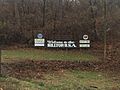
Hilltop, USA welcoming visitors
-
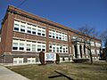
West Broad Street School
-
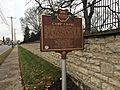
Camp Chase National Historical Marker
-
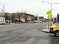
Broad Street, one of the main thoroughfares of Hilltop
-
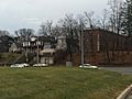
Housing stock found throughout Hilltop
-
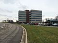
Ohio Department of Public Safety
.jpg)

