
Franklinton (Columbus, Ohio) facts for kids
Quick facts for kids
Franklinton
|
|
|---|---|
|
Neighborhood
|
|

Franklinton centered on Broad Street, west of Downtown
|
|
| Country | United States |
| State | Ohio |
| County | Franklin |
| City | Columbus |
| Founded | 1797 |
| Founded by | Lucas Sullivant |
| ZIP Code |
43215, 43222, 43223
|
| Area code(s) | 614/380 |

Franklinton is a neighborhood in Columbus, Ohio. It is located just west of downtown Columbus. Franklinton was first settled in 1797. It was the first American settlement in Franklin County. Franklinton was the county seat (the main government town) until 1824. As Columbus grew, it became part of the city in 1859.
Franklinton is surrounded by the Scioto River on its north and east sides. Harmon Avenue is to the east. Stimmel Road and Greenlawn Avenue are to the south. Interstate 70 is to the west. The main road through Franklinton is West Broad Street. It is one of Columbus's two main roads.
Some people call part of the neighborhood "The Bottoms." This is because the land is low and can flood easily. The Scioto and Olentangy rivers flow nearby. A special wall, called a floodwall, helps protect the area from floods. The low land was good for farming. The river also connected the area to the Ohio River. The floodwall was finished in 2004. This led to new buildings and changes in East Franklinton. Some older housing was removed, and new buildings were built.
Contents
Exploring Franklinton's Past
Early Settlement and Growth (1795–1859)

In 1795, a man named Lucas Sullivant was hired to map out land in Ohio. He worked with about 20 men. They mapped the area where the Olentangy and Scioto Rivers meet. Sullivant was paid with 6,000 acres of land. This land was set aside for people who helped in the American Revolution.
In 1797, Sullivant returned to Ohio. He planned a village with 220 lots. He named it Franklinton to honor Benjamin Franklin. This first settlement was right by the rivers. But in 1798, a big flood covered most of the town. So, Sullivant moved the settlement to higher ground nearby.


The new town was laid out in squares. Each square had four lots. To get people to move there, Sullivant offered free land. This was for anyone who would build a house on Gift Street. Sullivant also built several important buildings. These included a courthouse, a brick home, a church, and the first bridge over the Scioto River.
Franklinton became the county seat of Franklin County in 1803. The town grew during the War of 1812. Franklinton was a meeting point for General William Henry Harrison's army. After the war, the town kept growing. New railroads were built. Also, a new state capital, Columbus, was built across the Scioto River. Columbus grew quickly and became the county seat in 1824. Franklinton officially became part of Columbus in 1859.
Franklinton After Joining Columbus (1860–1899)

In the late 1800s, four railroads came to Franklinton. This brought more businesses and factories. The first railroad through Columbus and Franklinton was built in 1850. Railroads became a major way to travel. By 1902, trains were so popular that Ohio's canals were no longer used for transport.
Franklinton changed from a farming area to a city. It became known for its railroad cars and horse-drawn buggies. Many people moved to East Franklinton to be near the factories. However, frequent floods were a problem. Franklinton had many small floods. The river rose 12 feet in 1866.
In 1889, the city spent $50,000 to build large walls, called levees, along the Scioto River. Most of the houses in Franklinton today were built after these levees were finished.
In 1897, Columbus celebrated Franklinton's 100th birthday. Speakers praised Lucas Sullivant. But many also agreed that the flood-prone area was not the best place for a town.
Franklinton in the 20th Century
Franklinton faced a huge flood in 1913. After two days of heavy rain, the wooden levees broke. The flood covered Franklinton with 7 to 17 feet of water. Police warned residents to go to higher ground. Many people were rescued by boats. The flood killed 93 people and left 20,000 people without homes. It also destroyed almost 500 buildings and every bridge downtown. Many residents moved to the nearby Hilltop neighborhood. Property values dropped by half. This flood led to new plans for flood control.
In 1943, a company in East Franklinton helped with the Manhattan Project. This was a secret project to build nuclear weapons during World War II. The company made uranium for a nuclear reactor. Workers were not protected from radiation. The site was cleaned up in 2001. Most of the building was torn down in 2011.

The last major flood in Franklinton was in 1959. The Scioto River rose very high. The frozen ground made the flooding worse.
From 1977 to 1985, a popular club called Rudely Elegant was in Franklinton. It was known for its fun costume parties. It was a lively place for people to gather and socialize.
In 1983, the government said most of Franklinton was in a flood zone. This meant there was a 1% chance of a flood each year. New building rules were put in place. This caused Franklinton's population to slowly decrease.
The building of the Interstate Highway System in the 1960s also changed Franklinton. Some buildings were removed for the highways. This lowered property values. It also made East Franklinton feel cut off from the rest of the city.
Franklinton in the 21st Century


Today, Franklinton is an urban neighborhood with about 36,000 residents. New projects have improved the area. The Franklinton Floodwall was finished in 2004. It is 7 miles long and cost $134 million. It protects the area from floods up to 30.9 feet high. After the wall was built, the area was no longer considered a flood zone. This allowed new construction to begin. Businesses and factories are now growing in East Franklinton.
Between 2009 and 2011, several public housing projects were torn down. This reduced the population in East Franklinton. The city also helped fix up 16 homes. Franklinton also received money from government programs. This helped build, fix, or tear down over 100 houses.
The City of Columbus is working to create a new creative district in Franklinton. This area is centered around Gift, Town, Lucas, and Rich Streets. Developers are buying and fixing up old buildings. They want to keep the neighborhood's unique character.
Franklinton's Location and Features

Franklinton is a neighborhood bordered by the Scioto River to the north and east. Harmon Avenue is to the east. Stimmel Road and Greenlawn Avenue are to the south. Interstate 70 is to the west. West Broad Street is Franklinton's main road. It is also known as U.S. Route 40. Franklinton is just west of Downtown Columbus, Ohio. A floodwall protects the area from river floods. West of Franklinton is a group of smaller neighborhoods called "The Hilltop".
The Scioto Peninsula Area


The Scioto Peninsula is a piece of land on the west side of the Scioto River. It was part of the first Franklinton settlement. Most people still see it as part of Franklinton. However, some maps place it in Downtown Columbus. The city started calling it part of downtown in 1998. This was because of park improvements and the COSI museum.
The peninsula is surrounded by the Scioto River on three sides. It is also bordered by railroad tracks. This land used to be mostly for factories. Now, it has the National Veterans Memorial and Museum and the COSI science museum. It also has the Toledo and Ohio Central Railroad Station, a police station, and walking trails. There are also parks like Genoa Park and Dorrian Green. Other areas are used for parking or are empty lots.
Plans to develop this area started as early as 1908. The Columbus Plan imagined large buildings and green spaces. This would connect downtown to Franklinton. Only part of this plan happened. Modern planning for the site began in 1986. In 1997, new developments caused some people without homes to move.
The Scioto Peninsula project began planning in 2012. The first part of the project started in 2020. It includes an office building, a hotel, and two apartment buildings. These are expected to open in 2022. Eventually, the site might have 20 buildings. This could include 1,800 homes, 400 hotel rooms, and many offices and shops.
- Changes to the Land
-
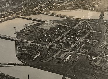
The peninsula around 1923
-
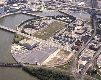
The peninsula in 1981


People and Homes in Franklinton
Population Changes
Franklinton's population has changed a lot over time. It was highest in 1950, with 26,500 people. Since then, the number of residents has gone down. In 2017, there were about 8,132 people living there.
How Land is Used

Franklinton has many different types of land use. It was once a self-sufficient community. Some areas mix homes, shops, offices, and light factories. Art-related businesses are encouraged. Existing single-family homes are also protected.
There are three main areas for land use: Broad Street, Arts and Innovation, and Dodge Park.
- The Broad Street and Arts and Innovation areas allow many different uses.
- The Dodge Park area, north of Dodge Park, is mostly for homes.
- Homes for single families and multiple families are found throughout Franklinton.
- Most shops and businesses are along West Broad Street. These include large offices and a shopping center.
- Many factories are located along McKinley and Harmon avenues.
- Franklinton also has public buildings and institutions. The Center of Science and Industry (COSI) and the National Veterans Memorial and Museum are major examples.
The City of Columbus has marked Franklinton as a "Community Reinvestment Area." This means new projects can get tax breaks.
Housing in Franklinton

In 2000, Franklinton had 5,444 housing units. About 18.4% of these were empty. Only 29.2% of homes were lived in by their owners. More homes in Franklinton are rented compared to other Columbus neighborhoods.
The Columbus Metropolitan Housing Authority (CMHA) used to run many public housing projects here. The CMHA helps people who need affordable housing. They also work to create good living environments. In the 2010s, CMHA housing projects in Franklinton were replaced by newer, mixed-use buildings.
The neighborhood has also had homeless shelters. Some have moved or closed over the years.
Important Places and Buildings
Parks and Green Spaces

Franklinton has several parks for residents to enjoy. These include Dodge Park, Genoa Park, Dorrian Green, McKinley Park, and Cody Park.
- Genoa Park is on the west bank of the Scioto River. It is over 2 acres and has a walking trail. It hosts events like Rhythm on the River.
- McKinley Park is a neighborhood park. It has athletic fields, basketball courts, picnic areas, and playgrounds.
- Cody Park has a playground and covers 0.29 acres.
Landmarks and Historic Sites

Franklinton has several community centers. These include the Dodge Recreation Center, Sullivant Gardens Community Center, and McDowell Senior Center. They offer facilities like athletic fields and swimming pools. Franklinton is also becoming a new creative district in Columbus.
Many buildings in Franklinton are on historic registers. Some notable ones include:
- Central High School
- Engine House No. 6
- Franklinton Post Office
- Gen. William Henry Harrison Headquarters
- Toledo and Ohio Central Railroad Station
Green Lawn Abbey

The Green Lawn Abbey was built in 1927. It is a private community mausoleum. It has a gray granite outside and columns. It has 654 crypts (spaces for burials). It also features marble floors, a central chapel, and stained-glass windows.
Holy Family Catholic Church
The Holy Family Catholic Church was built in the Gothic style. Construction began in 1881 and finished in 1889. The church can seat one thousand people. During the 1913 flood, its upper floors were used to help flood victims.
The Franklinton Floodwall
The Franklinton Floodwall started being built in 1993. It was finished in 2004. It cost $193 million. This wall protects the area from floods from the Scioto River. A flood in 1959 was one of the worst disasters in Franklinton's history.
Learning and Education
.jpg)
Franklinton is part of the Columbus City Schools district.
- West High School serves all high school students from Franklinton.
- Starling K-8 serves students in grades 6-8.
- Elementary school students attend Starling K-8, Sullivant Elementary, or Avondale Elementary.
- The Bellows Avenue Elementary School building is historic. It is being restored.
Private schools in the neighborhood include Columbus Collegiate Academy and Franklinton Prep Academy. There is also the West Central School for children with developmental disabilities.
The Mount Carmel College of Nursing is also in Franklinton. It was founded in 1903. The college offers different degrees in nursing.
Getting Around Franklinton
Transportation Options

Franklinton has a traditional street layout for cars and other traffic. The Central Ohio Transit Authority (COTA) has many bus routes in the neighborhood. These include routes 3, 6, 9, 10, 12. In 2017, about 40% of people in Franklinton did not have access to a car.
Main Streets
Broad Street is the main east-west road in Franklinton. Other important east-west roads include McKinley, Town, Sullivant, and Mound.
Broad Street is a very important road in Columbus. It is about 60 feet wide. Around 16,000 vehicles use it every day.
Sullivant Avenue is another major east-west road. It has four lanes and a median in the middle.
Emergency Services

Franklinton has one fire station, Station 10. In the past, when fire engines were not motorized, more fire stations were needed. This is why there were also Engine House No. 6 and Engine House No. 10.
Access to Food
Franklinton does not have a large grocery store. This means many residents have trouble getting enough food. In 2018, a small non-profit grocery store and cafe opened. It was the first of its kind in the city. It helps provide food for the community.
Franklinton in the Media
Franklinton was shown in the TV show 30 Days in 2005. The show follows people trying to live a different lifestyle for 30 days. In the episode, the host and his fiancé tried to live in Franklinton on minimum wage.
