Olentangy River facts for kids
Quick facts for kids Olentangy River |
|
|---|---|

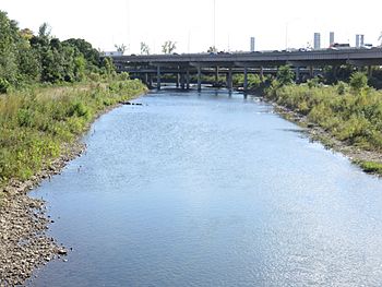
State Route 315 passing over the Olentangy in Columbus in 2018
|
|
| Physical characteristics | |
| Main source | Approximately 2 mi (3.2 km) southeast of Galion, Ohio 1,190 ft (360 m) |
| River mouth | Scioto River at Columbus 710 ft (220 m) |
| Basin features | |
| Basin size | 543 sq mi (1,410 km2) |
The Olentangy River is a 97-mile-long (156 km) tributary of the Scioto River in Ohio, United States. A tributary is a smaller river or stream that flows into a larger one.
Contents
River's Name: A Look at History
The Olentangy River had a different name long ago. The Delaware people, who are Native Americans, called it keenhongsheconsepung. This word means "sharp tool river." They named it this because of the shale rock found along its banks.
Early settlers in the area later called it the "Whetstone River." A whetstone is a tool used to sharpen blades.
In 1833, the Ohio General Assembly (Ohio's law-making group) wanted to bring back Native American names for some rivers. But they made a mistake! They gave the Whetstone River the name "Olentangy." This name actually means "river of the red face paint." It was supposed to be for a different river, now called Big Darby Creek.
Where Does the Olentangy River Flow?
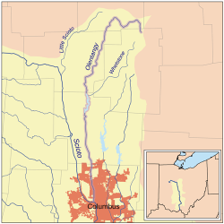
The Olentangy River starts in Morrow County. This is about 2 miles (3.2 km) southeast of Galion. It flows through Galion and then northwest towards Bucyrus.
After that, it turns south. It flows through eastern Marion County, Ohio, where some still call it the Whetstone River. Then it continues south into Delaware County.
The river keeps flowing south through towns like Delaware, Powell, and Worthington. It also passes through the village of Riverlea. Finally, it reaches Columbus and The Ohio State University campus. In downtown Columbus, it joins the larger Scioto River.
Delaware Lake: A Flood Control Project
The Delaware State Park Reservoir, also known as Delaware Lake, was built on the Olentangy River in 1951. The U.S. Army Corps of Engineers built this large lake. Its main purpose is to control floods.
On January 13, 2005, the water in Delaware Dam came very close to overflowing. It was less than 1 foot from the top! The main gates had to be opened to let water out. This helped prevent a flood.
Drinking Water Source
The Olentangy River is a very important source of drinking water. It provides water for much of Delaware County. Both the City of Delaware and Del-Co Water Company get most of their water from the Olentangy system. Del-Co Water Company supplies water to many rural areas in Delaware County.
Ohio's Scenic River Designation
About 22 miles of the Olentangy River have a special status. The Ohio Department of Natural Resources has named it a State Scenic River. This means it is a beautiful and important natural area.
Other Names for the Olentangy River
Over time, the Olentangy River has been known by several names. These include:
- Keenhongsheconsepung
- Oleutangy
- Whetstone Creek
- Whetstone River
- Whitestone Creek
Efforts to Restore the River
Since 2012, work has been done to help the Olentangy River. The Ohio EPA and the City of Columbus started removing some low dams. These dams used to cross the river.
One of the first dams removed was the 5th Avenue Dam. Now, the river is about half its original width in some places. Work is still ongoing to restore the river banks. These efforts help to clean the area and make the river healthier.
The Olentangy in Popular Culture
Famous sports broadcaster Keith Jackson often talked about the Olentangy River. When introducing Ohio State football games, he would say they were "from the banks of the mighty Olentangy."
 | May Edward Chinn |
 | Rebecca Cole |
 | Alexa Canady |
 | Dorothy Lavinia Brown |


