
Hobson's Conduit facts for kids

Hobson's Conduit, also known as Hobson's Brook, is an old waterway in Cambridge, England. It was built between 1610 and 1614. The main idea was to bring clean, fresh water into the city from natural springs at a place called Nine Wells. This area is now a special nature reserve near the village of Great Shelford.
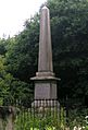
Today, Hobson's Conduit is a very important historical site. It's even protected as a Scheduled Ancient Monument. The water flows above ground until it reaches the Cambridge University Botanic Garden. Here, it becomes quite wide. You can see a special monument to Thomas Hobson at the corner of Lensfield Road. This monument used to be part of a fountain in the market square. It was moved here in 1856 after a big fire.
After Lensfield Road, the water flows underground for a bit. Then, it reappears in wide channels along both sides of Trumpington Street. It goes past colleges like Peterhouse and St Catharine's College. It also flows along St Andrew's Street. The conduit currently finishes near Silver Street.
The idea for this waterway first came up in 1574. A man named Andrew Perne suggested bringing water from the Nine Wells springs. He wanted to improve cleanliness in the town. The plan was later brought back by James Montagu. The University and the town paid for the building work. Thomas Hobson was one of the people involved. He set up a special trust to help maintain the waterway. This trust still exists today! The new channel was dug as a team effort between the University and the city.
Contents
How Hobson's Conduit Was Built

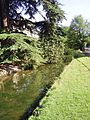
Hobson's Conduit was created by changing the path of another stream called Vicar's Brook. Vicar's Brook starts from chalk springs at Nine Wells, near Great Shelford. It flows east of Trumpington and goes under bridges on Long Road and Trumpington Road. Then it reaches Coe Fen, where it joins the River Cam.
The man-made channel, Hobson's Brook, splits off from Vicar's Brook. This happens between the two bridges. It runs next to Vicar's Brook, creating an area of common land. This land is now used for allotments. There's a public footpath along this part of the waterway. It used to be called Finch's or Senior Wrangler's Walk.
The stream gets wider as it goes along the edge of the University Botanic Gardens. It then passes under Bateman Street. Before it reaches the main dividing point at Lensfield Road, the channel flows between Brookside and Trumpington Street. This part runs through gardens with old iron railings.
Water Branches for Cambridge
At the main dividing point (called the conduit head) at Lensfield Road, the water was split into different branches. Each branch served a specific purpose in the city.
Trumpington Street Branch
This original branch still works today. It flows in channels along Trumpington Street. These channels are known as the Pem (on the east side) and the Pot (on the west side). The City Council controls how much water flows through these channels. They usually let water flow in the open conduits from April to September.
This branch also sends water into colleges like Peterhouse and Pembroke College. It used to send water to the old Addenbrooke's Hospital basement too.
Market Place Branch

This branch was finished in 1614. It brought fresh water to the Market fountain in the middle of Cambridge Market Place. After a fire in 1849, the Market Square was rebuilt. In 1855, a new fancy fountain was put up. The original structure of Hobson's Conduit was moved at this time. Most of the new fountain was taken down in 1953.
The water flow to this branch was stopped in 1960. This happened during the building of the Lion Yard shopping area. The water has not flowed to the Market Place since then.
St Andrew's Street Branch
This branch was added in 1631. It flowed from the main dividing point along Lensfield Road and St Andrew's Street. It went towards Drummer Street. There, it split again, sending water to Christ's and Emmanuel College. It also had a public dipping point where people could get water. Much of the open channel along St Andrew's Street was covered up in 1996. This was done to make the area better for people walking.
Parker's Piece Branch
There was also a branch that ran from the main dividing point towards Parker's Piece. This branch was used to fill a pond for cattle. However, this branch stopped working in 1827 when the pond was filled in.
Monuments to the Conduit
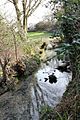
There are two special monuments related to Hobson's Conduit. One is on Lensfield Road. The other is at Nine Wells, where the springs are. The monument at Nine Wells was put up in 1861. It lists the people who helped pay for the watercourse and conduit. These important people include:
- Thomas Chaplin, who owned land in Trumpington, in 1610.
- Stephen Perse, a fellow at Gonville and Caius, in 1615.
- Thomas Hobson, a carrier, in 1630.
- Edward Potto, an alderman of Cambridge, in 1632.
- Joseph Merrill, another alderman of Cambridge, in 1806.
Images for kids
-
Monument to the conduit at Nine Wells
-
Spring at Nine Wells that feeds the conduit
-
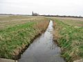
View along the conduit towards Nine Wells
-
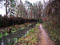
Footpath along conduit between Brooklands Avenue and Long Road
-
Hobson's conduit at the end of Brookside
-
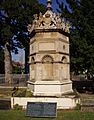
The Market fountain reerected at the point where the conduit crosses Lensfield Road as a monument to Hobson
-
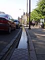
Hobson's conduit as it runs in a sluice toward Peterhouse


