Hogans Corner, Washington facts for kids
Quick facts for kids
Hogans Corner, Washington
|
|
|---|---|

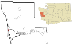
Location of Hogans Corner, Washington
|
|
| Country | United States |
| State | Washington |
| County | Grays Harbor |
| Area | |
| • Total | 0.32 sq mi (0.83 km2) |
| • Land | 0.31 sq mi (0.80 km2) |
| • Water | 0.02 sq mi (0.04 km2) |
| Elevation | 60 ft (20 m) |
| Population
(2020)
|
|
| • Total | 86 |
| • Density | 268/sq mi (103.6/km2) |
| Time zone | UTC-8 (Pacific (PST)) |
| • Summer (DST) | UTC-7 (PDT) |
| FIPS code | 53-31540 |
| GNIS feature ID | 2584983 |
Hogans Corner is a small community in Grays Harbor County, Washington, United States. It's known as a census-designated place (CDP), which means it's an area identified by the United States Census Bureau for statistical purposes. In 2020, about 86 people lived there. Before 2010, Hogans Corner was part of a larger area called Oyehut-Hogan's Corner.
Where is Hogans Corner Located?
Hogans Corner is found in the western part of Grays Harbor County. It's located where two state roads meet: Route 109 and Route 115.
- Route 109 goes east about 16 miles (26 km) to a city called Hoquiam. It also heads north along the Pacific Ocean coast to towns like Ocean City and Copalis Beach.
- Route 115 goes south about 2 miles (3.2 km) to Oyehut and Ocean Shores.
Land and Water Area
According to the United States Census Bureau, Hogans Corner covers a total area of about 0.83 square kilometers (0.32 square miles). Most of this area, about 0.80 square kilometers (0.31 square miles), is land. The remaining part, about 0.04 square kilometers (0.015 square miles), is water. This means about 4.21% of Hogans Corner is covered by water.
See also
 In Spanish: Hogans Corner para niños

