Holloway, Minnesota facts for kids
Quick facts for kids
Holloway, Minnesota
|
|
|---|---|

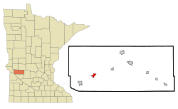
Location of Holloway, Minnesota
|
|
| Country | United States |
| State | Minnesota |
| County | Swift |
| Incorporated | February 14, 1903 |
| Area | |
| • Total | 1.401 sq mi (3.629 km2) |
| • Land | 1.400 sq mi (3.627 km2) |
| • Water | 0.001 sq mi (0.004 km2) |
| Elevation | 1,030 ft (310 m) |
| Population
(2020)
|
|
| • Total | 87 |
| • Estimate
(2022)
|
86 |
| • Density | 62.14/sq mi (23.99/km2) |
| Time zone | UTC−6 (Central (CST)) |
| • Summer (DST) | UTC−5 (CDT) |
| ZIP Code |
56249
|
| Area code(s) | 320 |
| FIPS code | 27-29672 |
| GNIS feature ID | 2394405 |
| Sales tax | 6.875% |
Holloway is a small city in Swift County, Minnesota, United States. In 2020, about 87 people lived there.
Contents
History of Holloway
Holloway has had a post office since 1889. The city was named after one of the first people to settle in the area.
Geography and Location
Holloway covers an area of about 1.4 square miles (3.6 square kilometers). Most of this area is land, with a very small part being water.
U.S. Route 59 is a main road that goes through the community.
Population and People
| Historical population | |||
|---|---|---|---|
| Census | Pop. | %± | |
| 1910 | 215 | — | |
| 1920 | 289 | 34.4% | |
| 1930 | 269 | −6.9% | |
| 1940 | 286 | 6.3% | |
| 1950 | 264 | −7.7% | |
| 1960 | 242 | −8.3% | |
| 1970 | 146 | −39.7% | |
| 1980 | 142 | −2.7% | |
| 1990 | 123 | −13.4% | |
| 2000 | 112 | −8.9% | |
| 2010 | 92 | −17.9% | |
| 2020 | 87 | −5.4% | |
| 2022 (est.) | 86 | −6.5% | |
| U.S. Decennial Census 2020 Census |
|||
2010 Census Information
According to the 2010 census, there were 92 people living in Holloway. All of the residents were identified as White.
The average age of people in Holloway was 53 years old. About 13% of the residents were under 18 years old.
See also
 In Spanish: Holloway (Minnesota) para niños
Black History Month on Kiddle
Outstanding African-American Women
 | Jewel Prestage |
 | Ella Baker |
 | Fannie Lou Hamer |

All content from Kiddle encyclopedia articles (including the article images and facts) can be freely used under Attribution-ShareAlike license, unless stated otherwise. Cite this article:
Holloway, Minnesota Facts for Kids. Kiddle Encyclopedia.
