Holly Springs, Georgia facts for kids
Quick facts for kids
Holly Springs, Georgia
|
||
|---|---|---|

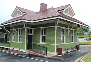
Holly Springs train depot
|
||
|
||

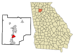
Location in Cherokee County and the state of Georgia
|
||
| Country | United States | |
| State | Georgia | |
| County | Cherokee | |
| Area | ||
| • Total | 7.29 sq mi (18.88 km2) | |
| • Land | 7.19 sq mi (18.62 km2) | |
| • Water | 0.10 sq mi (0.26 km2) | |
| Elevation | 1,109 ft (338 m) | |
| Population
(2020)
|
||
| • Total | 16,213 | |
| • Density | 2,254.94/sq mi (870.68/km2) | |
| Time zone | UTC-5 (Eastern (EST)) | |
| • Summer (DST) | UTC-4 (EDT) | |
| ZIP code |
30142
|
|
| Area code(s) | 770/678/470 | |
| FIPS code | 13-39524 | |
| GNIS feature ID | 0315567 | |
Holly Springs is a city located in Cherokee County, in the state of Georgia, United States. In 2020, about 16,213 people lived here. This was a big jump from 2000, when the population was 3,195.
Contents
History of Holly Springs
Holly Springs became an official town in 1906. It was named after some holly trees that grew near a natural spring in the area.
Geography of Holly Springs
Holly Springs is in the southern part of Cherokee County. It is located at 34 degrees, 9 minutes, 59 seconds North and 84 degrees, 30 minutes, 4 seconds West.
The city shares its borders with:
Interstate 575 runs through Holly Springs. You can get on or off the highway at exits 11 and 14. The city is about 36 miles (58 km) south of downtown Atlanta.
Land and Water
The United States Census Bureau says that Holly Springs covers a total area of about 7.3 square miles (18.88 square kilometers). Most of this area is land, about 7.2 square miles (18.62 square kilometers). A small part, about 0.1 square miles (0.26 square kilometers), is water.
Nearby Communities
Holly Springs is close to several smaller communities that are not officially part of a city. These include:
- Hickory Flat (to the east)
- Toonigh (to the southeast)
- Lebanon (to the south)
- Sixes (to the west) - This area is home to Fort Sixes, which was a fort used in the 1830s to help move Native American people.
Population and People
| Historical population | |||
|---|---|---|---|
| Census | Pop. | %± | |
| 1910 | 251 | — | |
| 1920 | 216 | −13.9% | |
| 1930 | 273 | 26.4% | |
| 1940 | 256 | −6.2% | |
| 1950 | 386 | 50.8% | |
| 1960 | 475 | 23.1% | |
| 1970 | 575 | 21.1% | |
| 1980 | 687 | 19.5% | |
| 1990 | 2,406 | 250.2% | |
| 2000 | 3,195 | 32.8% | |
| 2010 | 9,189 | 187.6% | |
| 2020 | 16,213 | 76.4% | |
| 2023 (est.) | 19,540 | 112.6% | |
| U.S. Decennial Census | |||
The population of Holly Springs has grown a lot over the years. A census is a count of all the people living in an area. The U.S. government does a census every ten years.
Population in 2020
In the 2020 United States census, there were 16,213 people living in Holly Springs. These people made up 4,145 households, and 3,205 of these were families.
The people living in Holly Springs come from many different backgrounds. Here's a look at the main groups:
| Group | Number | Percentage |
|---|---|---|
| White (not Hispanic or Latino) | 12,152 | 74.95% |
| Black or African American (not Hispanic or Latino) | 1,150 | 7.09% |
| Native American | 32 | 0.2% |
| Asian | 419 | 2.58% |
| Pacific Islander | 3 | 0.02% |
| Other or Mixed Race | 870 | 5.37% |
| Hispanic or Latino | 1,587 | 9.79% |
See also
 In Spanish: Holly Springs (Georgia) para niños
 | Kyle Baker |
 | Joseph Yoakum |
 | Laura Wheeler Waring |
 | Henry Ossawa Tanner |


