Homer, Kansas facts for kids
Quick facts for kids
Homer, Kansas
|
|
|---|---|

|
|
| Country | United States |
| State | Kansas |
| County | Russell |
| Founded | 1870s |
| Elevation | 1,870 ft (570 m) |
| Time zone | UTC-6 (CST) |
| • Summer (DST) | UTC-5 (CDT) |
| ZIP code |
67665
|
| FIPS code | 20-32925 |
| GNIS ID | 484730 |
Homer is a place in Russell County, Kansas, in the United States. It's sometimes called "Homer Station." It's not a town or city, but an unincorporated area. This means it doesn't have its own local government like a town does. Homer is right on the edge of two areas called Grant and Russell Townships.
Contents
Discovering Homer's Past
Homer was once an important stop along the Union Pacific Railroad line. Trains would pause here on their journey. From 1879 to 1887, a rural post office also served the area.
Exploring Homer's Location
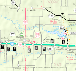
Homer is found at coordinates 38°52′10″N 98°47′51″W / 38.86944°N 98.79750°W. It sits about 1,867 feet (569 meters) above sea level. This spot is in the Smoky Hills region, which is part of the larger Great Plains.
Rivers and Nearby Towns
Homer is located about 5 miles (8 kilometers) north of the Smoky Hill River. It's also about 6.5 miles (10.5 kilometers) south of the Saline River. The area is roughly 3 miles (5 kilometers) east of Russell, which is the main town in the county. You can find Homer about 1 mile (1.5 kilometers) north of Interstate 70.
Getting Around Homer
Homer is located just east of where U.S. Route 40 Business crosses Homer Road. U.S. Route 40 Business runs from the southeast to the northwest. Homer Road is an unpaved county road that goes east and west.
Railroad Connections
The Kansas Pacific (KP) Line, which is part of the Union Pacific Railroad, runs right through Homer. This railway line goes alongside the U.S. 40 business route.


