
Hornopirén National Park facts for kids
Quick facts for kids Hornopirén National Park |
|
|---|---|
|
IUCN Category II (National Park)
|
|

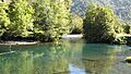
Blanco River, Hornopirén
|
|

Hornopirén National Park
Location in Chile
|
|
| Location | Los Lagos Region, Chile |
| Nearest city | Hornopirén |
| Area | 482 km2 |
| Established | 1988 |
| Governing body | Corporación Nacional Forestal |
Hornopirén National Park is a special place located in the Andes mountains of Chile. It's found in the Los Lagos Region, which is also known as Region X. This park covers about 482 square kilometers (that's 186 square miles) of amazing mountains and beautiful, untouched forests.
The park is next to Pumalín Park and is close to a famous road called the Carretera Austral. You can also find two volcanoes nearby: Hornopirén and Yate.
Contents
Exploring the Park's Geography
This park is a big part of the Andes mountain range. It has 22 hectares of mountains, glaciers, and volcanoes. The area is mostly shaped by glaciers and has active volcanoes.
Mountains and Volcanoes
The park is home to glaciers that cover about 30 square kilometers (11.5 square miles). The Yate volcano is very tall, reaching 2,187 meters (7,175 feet) above sea level. The Hornopirén volcano is 1,572 meters (5,157 feet) tall.
From the southern side of Yate volcano, even at 1,500 meters (4,921 feet) high, you can see amazing views. You can look out over the mountains and forests of the park. You'll also get a full view of Pinto Concha Lake and the Hornopirén fjord.
Waterways and Lakes
The park has three main bodies of water. These are Pinto Concha Lake, Cabrera Lake, and Inexplorado Lake. Pinto Concha Lake is the biggest and most popular spot for visitors.
Rivers and Unique Water Colors
There are six main rivers flowing through the park. Inexplorado Lake is part of a series of lakes called paternoster lakes. These lakes are connected and form part of the Blanco River system.
The lakes and rivers here have special blue and green colors. This is because of tiny bits of rock, called rock flour, that float in the water. This rock flour gives the Blanco River its milky look. The Negro River is another important river system in the park.
Ancient Forests of Hornopirén
The lakes and rivers in the park are surrounded by very old forests. These forests are filled with alerce trees, which are also known as larch trees.
The Alerce Tree: A Living Legend
The Alerce tree is incredibly special because it's the second oldest tree species on Earth! Many of these ancient Fitzroya trees grow together in large groups. These untouched alerce forests cover about 97.41 square kilometers (37.6 square miles). This means they make up about 35 percent of all the plants in the park.
Amazing Wildlife
Hornopirén National Park is home to about 25 different kinds of mammals. Some of these animals are native to the area, while others were brought in from other places.
Animals of the Park
You might spot animals like the cougar, a wild cat, or the small kodkod. There's also the lesser grison, a type of weasel, and the chilla fox. Other animals include the American mink, the coypu (a large rodent), the tiny pudú deer, and the special Chilean huemul deer. The park is very important because it protects 18 species that are currently threatened.
Visiting Hornopirén National Park
The park is managed by CONAF. Their office is in the city of Hornopirén, right in the central square. This is where most trips to the park begin. The best part is, it's free to enter the park!
Getting There and Around
You can drive to some parts of the park, but other areas can only be explored on foot. To reach the park from Hornopirén, you drive 11 kilometers (6.8 miles) north on Av. Lib. Bernardo O’Higgins. Then, there's another 7 kilometers (4.3 miles) on a bumpy gravel road through private land to get to the park entrance.
The park is about 107 kilometers (66 miles) from Puerto Montt. You can take a bus from Puerto Montt to Hornopirén National Park. The bus trip usually takes about 5 hours.
Facilities and Rules
There is a shelter in the park, but it's mainly for the CONAF park ranger. During the summer, the ranger provides information to visitors at this shelter, which is on the southwest side of Pinto Concha Lake.
There's a special area for camping, but it doesn't have any services. This means there are no barbecue spots or drinking water available. It's very important to know that campfires are not allowed in or around the park.
Park Trails
The park has two official trails that are kept in good condition for visitors to use.
Weather in the Park
The weather in Hornopirén National Park can be quite wet. The average rainfall each year is about 2,500 millimeters (98 inches), but it can sometimes be more than 4,000 millimeters (157 inches)!
Temperatures and Frost
Temperatures usually stay between 9 and 12 degrees Celsius (48 to 54 degrees Fahrenheit). There are also between 50 and 150 days each year when it freezes.
Winter Closures
The park closes to visitors between July and November. This is because a lot of snow and ice, sometimes over a meter (3 feet) thick, builds up in the recreation areas, making it unsafe to visit.
Images for kids
-
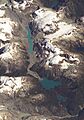
Unexplored Lake is the largest lake visible in lower half of the image.
-
Hornopirén


See also
 In Spanish: Parque nacional Hornopirén para niños
