Horribilis Peak facts for kids
Quick facts for kids Horribilis Peak |
|
|---|---|

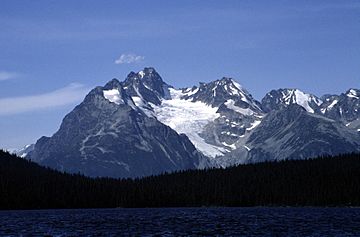
Horribilis Peak from Kidney Lake
|
|
| Highest point | |
| Elevation | 2,597 m (8,520 ft) |
| Geography | |
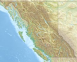
| Location | Range 3 Coast Land District British Columbia, Canada |
| Parent range | Pacific Ranges Coast Mountains |
| Topo map | NTS 93D/01 |
| Climbing | |
| First ascent | 1964 |
Horribilis Peak is a tall mountain in British Columbia, Canada. It stands about 2,597 meters (8,520 feet) high. This peak is part of the Coast Mountains and the Pacific Ranges.
The mountain is located about 5.5 kilometers (3.4 miles) north of Talchako Mountain. It is also about 28 kilometers (17 miles) south of Stuie. The closest taller mountain is Utan Peak, which is about 4 kilometers (2.5 miles) to the northwest.
A group of climbers led by George Whitemore named the peak in 1964. They chose the name "Horribilis" because they saw many grizzly bears in the area. The name became official on April 15, 1984, thanks to the Geographical Names Board of Canada. Rain and melted snow from the mountain flow into Ape Creek. This creek then joins the Talchako River.
Climate at Horribilis Peak
Horribilis Peak has a "marine west coast" climate. This type of climate is common in western North America. It means the area often has mild, wet weather.
Most weather systems start over the Pacific Ocean. They travel east towards the Coast Mountains. When these weather systems hit the mountains, they are forced to rise. This process is called Orographic lift. As the air rises, it cools and drops its moisture. This causes a lot of rain or snow to fall on the Coast Mountains.
Because of this, the Coast Mountains get a lot of precipitation. This is especially true during the winter months, when heavy snowfall is common. Temperatures on Horribilis Peak can drop very low. They can go below −20 °C (−4 °F). With the wind chill, it can feel even colder, sometimes below −30 °C (−22 °F).
 | Dorothy Vaughan |
 | Charles Henry Turner |
 | Hildrus Poindexter |
 | Henry Cecil McBay |


