Talchako Mountain facts for kids
Quick facts for kids Talchako Mountain |
|
|---|---|

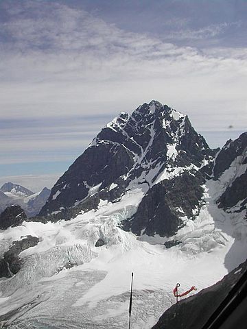
Talchako Mountain from the northwest
|
|
| Highest point | |
| Elevation | 3,037 m (9,964 ft) |
| Geography | |
| Parent range | Pacific Ranges of the Coast Mountains |
| Topo map | NTS 93D/01 |
| Climbing | |
| First ascent | 1961 by G. Whitemore, J. Wilson, R. Houston |
| Easiest route | rock scramble |
Talchako Mountain is a major peak in the Pacific Ranges. This is a part of the Coast Mountains in southern British Columbia, Canada. It stands west of the Talchako River. It is also north of the Monarch Icefield, which is a large area of ice.
The mountain is about 5.5 kilometers (3.4 miles) south of Horribilis Peak. It is also 33 kilometers (20 miles) south of Stuie.
About Talchako Mountain
The north side of Talchako Mountain has steep rock and snow. It also has a glacier. The south part of the mountain has rocky channels and snow. The east side is very impressive. It rises 1000 meters (about 3,280 feet) or more. Climbing this side needs special skills and equipment.
Mountain Weather
Talchako Mountain is in a "marine west coast" climate zone. This means it gets a lot of rain and snow. This type of climate is found in western North America.
How Weather Works Here
Most weather systems start over the Pacific Ocean. They move east towards the Coast Mountains. When these weather systems hit the mountains, they are forced to rise. As the air rises, it cools down. This causes the moisture in the air to turn into rain or snow. This process is called "orographic lift."
Because of this, the Coast Mountains get a lot of precipitation. This is especially true during the winter months when there is heavy snowfall. Temperatures on the mountain can drop very low. They can go below −20 °C (or −4 °F). With wind, it can feel even colder, below −30 °C (or −22 °F).
 | Sharif Bey |
 | Hale Woodruff |
 | Richmond Barthé |
 | Purvis Young |


