Horseshoe Bend (Arizona) facts for kids
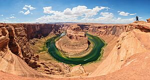
Imagine a giant, U-shaped curve carved deep into the Earth by a powerful river! That's exactly what Horseshoe Bend is. It's a stunning natural wonder where the Colorado River makes a dramatic turn, shaped like a horseshoe. You can find this amazing spot near the town of Page in Arizona, United States. Many people even call it the "east rim of the Grand Canyon" because it's so impressive!
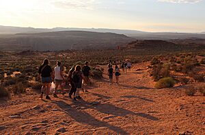
This incredible bend is located about 5 kilometers (3 miles) downstream from the Glen Canyon Dam and Lake Powell. It's part of the beautiful Glen Canyon National Recreation Area. To get there, you can take a short hike of about 2.4 kilometers (1.5 miles) round trip from a parking area right off U.S. Route 89 near Page. The land south of the parking area and the trail belongs to the Navajo Nation.
From the top of the steep cliff, you get an incredible view of the river below. The overlook is about 1,280 meters (4,200 feet) above sea level, while the Colorado River flows at about 975 meters (3,200 feet) above sea level. This means there's a breathtaking drop of about 305 meters (1,000 feet) from where you stand to the river!
How Horseshoe Bend Was Formed
Horseshoe Bend is a fantastic example of what geologists call an entrenched meander. This means it's a river curve that has cut deeply into the rock. About six million years ago, the area around Horseshoe Bend was much flatter, closer to sea level. The Colorado River flowed gently, winding across a wide, nearly flat floodplain.
Then, between six and five million years ago, something big happened: the entire region began to slowly lift upwards. This uplift trapped the Colorado River in its existing winding path. As the land rose, the river had to work harder, cutting downwards very quickly through the rock. This powerful erosion created the deep, U-shaped canyon of Horseshoe Bend that we see today.
Why Did the Land Uplift?
Scientists are still studying exactly why this land uplift happened. One idea is that deep layers of rock beneath the Colorado Plateau detached and sank into the Earth's hot interior, allowing hotter rock to rise and push the surface up. Another idea suggests that heating at the base of the Earth's crust changed some dense rocks into lighter ones, which then floated upwards, lifting the land above.
Whatever the exact cause, this uplift led to a lot of erosion. Over time, about 1.6 kilometers (1 mile) of rock and soil were worn away from the eastern Grand Canyon area. This exposed the Navajo Sandstone, which is the main type of rock you see all around Horseshoe Bend. This sandstone is special because it has cool patterns called crossbedding and round, hard lumps of iron called concretions.
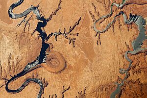
It's likely that in the very distant future, the Colorado River might cut straight through the narrow neck of the bend. If this happens, it could create a natural bridge, similar to those found at Natural Bridges National Monument in Utah. The river would then leave behind the old Horseshoe Bend, creating what's called a cutoff meander. You can see an example of a cutoff meander called The Rincon, further north along the Colorado River in Utah.
Visiting Horseshoe Bend
For a long time, Horseshoe Bend was mostly known by people living nearby. However, its popularity grew incredibly fast, especially thanks to photos and videos shared on social media. Now, the overlook is a major tourist spot, attracting more than 2 million visitors every year!
To help manage the large number of visitors and protect the area, the city government of Page started charging a fee in 2019 to use the parking area off U.S. Route 89. This also stopped people from parking on the highway itself. As of 2025, the fee is $10 for each passenger car. Between 2019 and May 2024, Page collected $20.3 million from these fees. This money helps fund important city services, making sure the area remains beautiful and safe for everyone.
See also
 In Spanish: Curva de la Herradura para niños
 | Jessica Watkins |
 | Robert Henry Lawrence Jr. |
 | Mae Jemison |
 | Sian Proctor |
 | Guion Bluford |


