
Horsetooth Reservoir facts for kids
Quick facts for kids Horsetooth Reservoir |
|
|---|---|
 |
|

Horsetooth Reservoir
Location in Colorado

Horsetooth Reservoir
Location in the United States
|
|
| Location | Larimer County, Colorado |
| Coordinates | 40°33′16″N 105°09′21″W / 40.55436°N 105.15591°W |
| Type | reservoir |
| Basin countries | United States |
| Max. depth | 200 ft (61 m) |
| Water volume | 156,735 acre⋅ft (0.193330 km3) |
| Surface elevation | 5,430 ft (1,660 m) |

Horsetooth Reservoir, often called Horsetooth by locals, is a large reservoir in Larimer County, Colorado. It sits in the foothills just west of Fort Collins, Colorado. The reservoir stretches about 6.5 miles (10 km) from north to south and is about half a mile (1 km) wide. Its long, narrow shape comes from being built between natural rock ridges. These ridges have created several bays and coves, like Inlet Bay, which has a marina and campgrounds.
The reservoir was built in 1949 by the Bureau of Reclamation. This was part of a big government project called the Colorado-Big Thompson Project, or "C-BT." This project helps move water from the western side of the continental divide (the Rocky Mountains) to the drier eastern side. Horsetooth Reservoir and Carter Lake are the two main places where this water is stored.
Horsetooth Reservoir provides extra drinking water for Fort Collins, Greeley, and other nearby towns. It also supplies water for irrigation (watering crops) in the lower South Platte River basin. The reservoir gets its name from Horsetooth Mountain, a peak in the foothills west of the reservoir's southern end.
Contents
Building Horsetooth Reservoir
The construction of Horsetooth Reservoir changed the area a lot. It covered parts of a small community called Stout. Before the reservoir was built, most of the town moved to a new spot. This new area is now around Horsetooth's South Bay. However, some old building foundations, like the schoolhouse, are now underwater.
The reservoir can hold a lot of water, about 156,735 acre-feet. It has a shoreline that stretches for 25 miles (40 km). In recent years, the water levels have sometimes been low. But in June 2014, the reservoir was almost completely full, reaching 98.6% of its capacity. This was the highest it had been in four years.
The Dams of Horsetooth
Horsetooth Reservoir was created by building four large earthen dams. These dams were all finished in 1949. They were later updated between 2000 and 2004 to make them safer against earthquakes.
Here are the four dams, listed from north to south:
- Horsetooth Dam: This dam closes the northern end of the reservoir. It is 155 feet (47 meters) tall.
- Soldier Canyon Dam: This dam is 226 feet (69 meters) tall.
- Dixon Canyon Dam: This dam is 240 feet (73 meters) tall.
- Spring Canyon Dam: This dam is 220 feet (67 meters) tall.
Together, these dams are made of more than 10 million cubic yards of earth.
Fun Things to Do at Horsetooth
Horsetooth Reservoir is a very popular place for outdoor activities. About 570,000 people visit Horsetooth every year. Larimer County Parks and Open Lands manages the recreation here. They have been in charge of fun activities at Horsetooth and three other reservoirs since the early 1950s. The reservoir is surrounded by 1,900 acres of public land.
Water Activities
Boating is very popular during the summer months. You can also go swimming at the special Swim Beach, which is looked after by Larimer County. Swimming is also allowed in some of the coves. Many people enjoy kayaking and canoeing on the water.
Fishing is a favorite activity from boats or from the shore. However, you are no longer allowed to fish from the dams because of security rules.
Land Activities
Since the late 1960s, bouldering has become a popular climbing sport at the reservoir. The hard sandstone rocks offer many challenging climbs for athletes. However, cliff diving is not allowed anywhere in the reservoir because it is dangerous. Park rangers patrol the area to make sure everyone stays safe.
Road cycling around Horsetooth is also popular. Many people also enjoy hiking and mountain biking, especially along the Foothills Trail. This trail runs along the eastern side of the reservoir. The City of Fort Collins has several open spaces right below the reservoir. Also, Lory State Park, which is owned by the state, is along the northwestern shore of the reservoir.
Images for kids
-
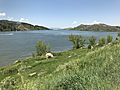
Horsetooth Reservoir at 98.8% full in June 2021.
-
Inlet Bay at Horsetooth Reservoir
-
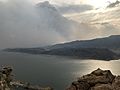
The reservoir shrouded in smoke from the approaching Cameron Peak wildfire in October 2020.
-

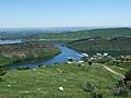
View to the east across midsection of Horsetooth Reservoir towards Fort Collins. Sandstone escarpments of the ridges that border the reservoir are visible. Also shown are the (l to r) Dixon Canyon and Spring Canyon dams, as well as glimpses of Quarry and Dixon Coves in the foreground.


See also
