
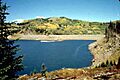
List of largest reservoirs in Colorado facts for kids

Colorado is a state in the United States known for its beautiful mountains and wide-open spaces. But did you know it also has many large reservoirs? Reservoirs are like big, artificial lakes where water is stored. This water is super important for many things, like providing drinking water for cities, helping farmers grow crops, and even creating electricity.
This article lists the biggest reservoirs in Colorado. There are 38 of them that hold more than 40,000 acre-feet of water. An acre-foot is a way to measure water – it's enough water to cover one acre of land (about the size of a football field) with water one foot deep!
Most of these large reservoirs are managed by the United States Bureau of Reclamation or the United States Army Corps of Engineers. Some are also owned by private companies. They help control floods and make sure there's enough water for farms. The biggest reservoir completely inside Colorado is Blue Mesa Reservoir. It can hold a huge amount of water – about 829,500 acre-feet!
Contents
What are Reservoirs For?
Reservoirs are very important for people living in Colorado. Here's why:
- Drinking Water: Many cities and towns get their drinking water from these large reservoirs.
- Farming: Farmers use the stored water to irrigate their crops, especially in drier parts of the state.
- Flood Control: Reservoirs can hold back extra water during heavy rains or snowmelt, which helps prevent floods downstream.
- Recreation: Many reservoirs are also popular spots for fun activities like boating, fishing, and swimming.
- Electricity: Some reservoirs have dams with power plants that use the flowing water to create electricity.
Understanding the List
The list below shows some of the largest reservoirs in Colorado. You'll see some special symbols next to their names:
 means the reservoir is not entirely in Colorado. Part of it might be in another state.
 means the reservoir is "offstream." This means it's not directly on a main river. Instead, water is brought to it through canals from a river.
Top Reservoirs in Colorado
Here are some of the biggest and most important reservoirs in Colorado:

Navajo Reservoir is the largest reservoir that touches Colorado. It's so big that parts of it are also in New Mexico! It holds over 1.7 million acre-feet of water. This reservoir is fed by the San Juan River and is held back by the Navajo Dam. It's a popular place for boating and fishing.
Blue Mesa Reservoir

This is the biggest reservoir completely within Colorado. It's located in Gunnison County and is part of the Gunnison River system. Blue Mesa Reservoir is a key part of the Curecanti National Recreation Area, offering lots of outdoor activities. It's held by the Blue Mesa Dam.
John Martin Reservoir

Located in Bent County, John Martin Reservoir is a major spot on the Arkansas River. It's important for flood control and providing water for irrigation in the eastern plains of Colorado.
Lake Granby

Lake Granby is found in Grand County. It's a big part of the Colorado-Big Thompson Project, which moves water from the western side of the Rocky Mountains to the drier eastern side. It's fed by the Colorado River and held by the Granby Dam.
McPhee Reservoir

This reservoir is in Montezuma County and is fed by the Dolores River. McPhee Reservoir is very important for providing water to farms in southwestern Colorado.
Pueblo Reservoir

Pueblo Reservoir is located near the city of Pueblo in Pueblo County. It's another important reservoir on the Arkansas River, used for water supply and recreation.
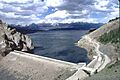
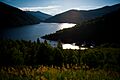
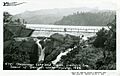
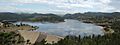
Dillon Reservoir
.jpg)
High up in the mountains in Summit County, Dillon Reservoir is a beautiful lake that supplies drinking water to the city of Denver. It's fed by the Blue River and is a popular place for sailing and other water sports.
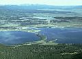
Horsetooth Reservoir

Horsetooth Reservoir is located near Fort Collins in Larimer County. It's an "offstream" reservoir, meaning water is brought to it through canals from the Colorado River as part of the Colorado-Big Thompson Project. It's a favorite spot for hiking, biking, and boating.
Images for kids
-
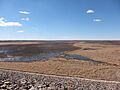
Bonny Reservoir (drained in 2011)
-
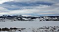
Green Mountain Reservoir
-
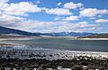
Twin Lakes Reservoir
-
Sanchez Reservoir
-
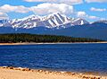
Turquoise Lake (with Mt. Elbert in the background)
-

Vallecito Reservoir
-
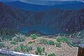
Morrow Point Reservoir
-
Carter Lake Reservoir
-
Taylor Park Reservoir
-
Ruedi Reservoir
-
Williams Fork Reservoir
-
Cherry Creek Reservoir
-
Ridgway Reservoir
-
Cheesman Lake
-
Platoro Reservoir
-
Boyd Lake
-
Two Buttes Reservoir
-
Gross Reservoir
-
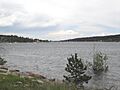
Lemon Reservoir


See also
