Houston County, Tennessee facts for kids
Quick facts for kids
Houston County
|
|||
|---|---|---|---|

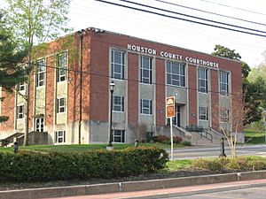
Houston County Courthouse in April 2014
|
|||
|
|||

Location within the U.S. state of Tennessee
|
|||
 Tennessee's location within the U.S. |
|||
| Country | |||
| State | |||
| Founded | 1871 | ||
| Named for | Sam Houston | ||
| Seat | Erin | ||
| Largest city | Erin | ||
| Area | |||
| • Total | 207 sq mi (540 km2) | ||
| • Land | 200 sq mi (500 km2) | ||
| • Water | 6.7 sq mi (17 km2) 3.2%% | ||
| Population
(2020)
|
|||
| • Total | 8,283 |
||
| • Density | 42/sq mi (16/km2) | ||
| Time zone | UTC−6 (Central) | ||
| • Summer (DST) | UTC−5 (CDT) | ||
| Congressional district | 7th | ||
Houston County is a cool place in the state of Tennessee. It's like a special area within the state. In 2020, about 8,283 people lived here. The main town, or 'county seat,' is Erin. That's where the county government offices are located. Houston County was started in 1871 and got its name from a famous person, Sam Houston.
Contents
Exploring Houston County
This section tells you more about Houston County. You can learn about its size, where it is, and the main roads that go through it.
Where is Houston County?
Houston County covers about 207 square miles. Most of this area, around 200 square miles, is land. The rest, about 6.7 square miles, is water.
Neighboring Counties
Houston County shares its borders with several other counties. These are like its neighbors on a map:
- Stewart County to the north
- Montgomery County to the northeast
- Dickson County to the east
- Humphreys County to the south
- Benton County to the west
Main Roads in Houston County
Several important roads help people travel through Houston County. These are state routes, which are roads managed by the state of Tennessee:
- State Route 13
- State Route 46
- State Route 49
- State Route 147
- State Route 149
- State Route 231
- State Route 232
People of Houston County
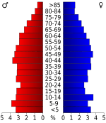
This section shares information about the people who live in Houston County. We can see how the population has changed over many years.
| Historical population | |||
|---|---|---|---|
| Census | Pop. | %± | |
| 1880 | 4,295 | — | |
| 1890 | 5,390 | 25.5% | |
| 1900 | 6,476 | 20.1% | |
| 1910 | 6,224 | −3.9% | |
| 1920 | 6,212 | −0.2% | |
| 1930 | 5,555 | −10.6% | |
| 1940 | 6,432 | 15.8% | |
| 1950 | 5,318 | −17.3% | |
| 1960 | 4,794 | −9.9% | |
| 1970 | 5,845 | 21.9% | |
| 1980 | 6,871 | 17.6% | |
| 1990 | 7,018 | 2.1% | |
| 2000 | 8,088 | 15.2% | |
| 2010 | 8,426 | 4.2% | |
| 2020 | 8,283 | −1.7% | |
| U.S. Decennial Census 1790-1960 1900-1990 1990-2000 2010-2020 2020 |
|||
Population in 2020
In 2020, the census counted 8,283 people living in Houston County. There were 2,878 households, which are groups of people living together. Also, there were 1,750 families.
Most people in Houston County are White (about 90.44%). There are also people who are Black or African American (2.41%), Native American (0.39%), Asian (0.19%), and Pacific Islander (0.1%). About 4.03% of the population identifies as other races or mixed races. Around 2.44% of the people are Hispanic or Latino.
Schools in Houston County
Education is important in Houston County! Here are the public schools where students learn and grow.
High Schools
- Houston County High School: This school has about 465 students. It is located at 2500 State Route 149 and teaches grades 9 through 12.
- Houston County Adult High School: This school has a few students, about 2. It is located at 3573 West Main Street and teaches grades 11 through 12.
Elementary and Middle Schools
- Erin Elementary School: This school has about 456 students. It is located at 6500 State Route 13 and teaches grades Kindergarten through 5.
- Tennessee Ridge Elementary School: This school has about 280 students. It is located at 135 School Street and teaches grades Kindergarten through 5.
- Houston County Middle School: This school has about 338 students. It is located at 1241 West Main Street and teaches grades 6 through 8.
Local Media
Want to know what's happening in Houston County? Here's how people get their news and entertainment.
- FM Radio: You can listen to WTPR-FM 101.7, which plays "The Greatest Hits of All Time."
- Weekly Newspaper: The local newspaper is called the Houston County Herald and comes out once a week.
- TV Station: There's also the Wells Creek Basin Network for local television.
Communities in Houston County
Houston County has different types of communities where people live.
City
- Erin: This is the biggest town and the county seat.
Town
- Tennessee Ridge: This town is partly in Houston County and partly in Stewart County.
Smaller Communities
These are smaller areas that are not officially cities or towns, but people live there:
See also
 In Spanish: Condado de Houston (Tennessee) para niños
 | Mary Eliza Mahoney |
 | Susie King Taylor |
 | Ida Gray |
 | Eliza Ann Grier |


