Montgomery County, Tennessee facts for kids
Quick facts for kids
Montgomery County
|
|||
|---|---|---|---|

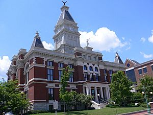
Montgomery County Courthouse in Clarksville
|
|||
|
|||

Location within the U.S. state of Tennessee
|
|||
 Tennessee's location within the U.S. |
|||
| Country | |||
| State | |||
| Founded | April 9, 1796 | ||
| Named for | John Montgomery | ||
| Seat | Clarksville | ||
| Largest city | Clarksville | ||
| Area | |||
| • Total | 544 sq mi (1,410 km2) | ||
| • Land | 539 sq mi (1,400 km2) | ||
| • Water | 4.7 sq mi (12 km2) 0.9%% | ||
| Population
(2020)
|
|||
| • Total | 220,069 | ||
| • Estimate
(2023)
|
239,872 |
||
| • Density | 404.5/sq mi (156.19/km2) | ||
| Time zone | UTC−6 (Central) | ||
| • Summer (DST) | UTC−5 (CDT) | ||
| Congressional district | 7th | ||
Montgomery County is a county in the state of Tennessee, USA. It is located in the northern part of the state, right next to the border with Kentucky. As of the 2020 United States census, about 220,069 people lived here.
The main city and county seat of Montgomery County is Clarksville. This is the only official city within the county. Montgomery County was created a long time ago, in 1796. It is part of the larger Clarksville Metropolitan Statistical Area, which includes parts of both Tennessee and Kentucky.
Contents
History of Montgomery County
Montgomery County is named after John Montgomery. He was a soldier during the American Revolutionary War and one of the first people to settle in this area. He also helped start the city of Clarksville.
The county was officially formed on April 9, 1796. Before that, this land was part of a larger area called Tennessee County. When Tennessee became a new state, Montgomery County was created. Over the years, the county's size changed a few times, but by 1871, it reached its current borders.
Saltpeter Mining in Montgomery County
Long ago, Montgomery County was important for its saltpeter mines. Saltpeter is a key ingredient used to make gunpowder. People got it by digging up earth from local caves and processing it.
For example, Bellamy Cave near Stringtown still has the remains of many saltpeter processing areas. This shows it was a big operation. Cooper Creek Cave also has signs of a lot of mining. These caves were likely used to get saltpeter during the War of 1812. Dunbar Cave was also used for saltpeter mining around the time of the Mexican War in 1848. However, later building projects have removed most of the evidence there. Mining probably stopped during the Civil War because the Union Army took control of this part of Tennessee early in the war.
Geography of Montgomery County
Montgomery County is located on the northern border of Tennessee, right next to Kentucky. The land here is quite hilly, with many valleys and streams. Most of the county is covered with trees. The Cumberland River flows through the lower central part of the county, winding its way westward.
The highest point in the county is a small hill that is about 806 feet (246 meters) above sea level. This hill is located a few miles east-northeast of Slayden.
The U.S. Census Bureau says that Montgomery County covers a total area of 544 square miles (1,410 square kilometers). Out of this, 539 square miles (1,396 square kilometers) is land, and only 4.7 square miles (12 square kilometers) is water.
Dunbar Cave
Montgomery County has a special type of landscape called karst topography. This means there are many caves and sinkholes underground. A very large cave system in the county is called Dunbar Cave. It is the main feature of Dunbar Cave State Park, which covers about 110 acres. This park is one of the most popular state parks in Tennessee.
Dunbar Cave was used a lot by Native Americans thousands of years ago. They lived in this area for a very long time before Europeans arrived. Inside the cave, researchers have found pieces of their cane torches and many ancient tools and items.
On January 15, 2005, a park ranger and some historians found ancient drawings, called glyphs, on the cave walls. Later, experts confirmed these drawings were made by people of the Mississippian culture, who lived here between 1000 and 1300 CE. These special drawings were shown on cave tours for several years.
In 2010, the State of Tennessee temporarily closed Dunbar Cave to the public. This was because a bat was found with White Nose Syndrome, a serious disease that affects bats. The state wanted to prevent the disease from spreading. The cave has since reopened for tours, which happen seasonally from May to August. Special cleaning rules are in place to keep the bats safe.
Nearby Counties
- Christian County, Kentucky - to the northwest
- Todd County, Kentucky - to the northeast
- Robertson County - to the east
- Cheatham County - to the southeast
- Dickson County - to the south
- Houston County - to the southwest
- Stewart County - to the west
Protected Natural Areas
- Barnett's Woods State Natural Area
- Dunbar Cave State Natural Area
- Dunbar Cave State Park
- Haynes Bottom Wildlife Management Area
- Port Royal State Park (part of it)
- Shelton Ferry Wildlife Management Area
Population of Montgomery County
| Historical population | |||
|---|---|---|---|
| Census | Pop. | %± | |
| 1800 | 2,899 | — | |
| 1810 | 8,021 | 176.7% | |
| 1820 | 12,219 | 52.3% | |
| 1830 | 14,349 | 17.4% | |
| 1840 | 16,927 | 18.0% | |
| 1850 | 21,045 | 24.3% | |
| 1860 | 20,895 | −0.7% | |
| 1870 | 24,747 | 18.4% | |
| 1880 | 28,481 | 15.1% | |
| 1890 | 29,697 | 4.3% | |
| 1900 | 36,017 | 21.3% | |
| 1910 | 33,672 | −6.5% | |
| 1920 | 32,265 | −4.2% | |
| 1930 | 30,882 | −4.3% | |
| 1940 | 33,346 | 8.0% | |
| 1950 | 44,186 | 32.5% | |
| 1960 | 55,645 | 25.9% | |
| 1970 | 62,721 | 12.7% | |
| 1980 | 83,342 | 32.9% | |
| 1990 | 100,498 | 20.6% | |
| 2000 | 134,768 | 34.1% | |
| 2010 | 172,331 | 27.9% | |
| 2020 | 220,069 | 27.7% | |
| 2023 (est.) | 239,872 | 39.2% | |
| US Decennial Census 1790-1960 1900-1990 1990-2000 2010-2014 |
|||
2020 Census Information
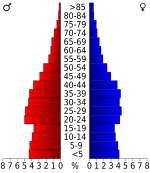
The 2020 United States census counted 220,069 people living in Montgomery County. Here's a look at the different groups of people living there:
| Race | Number | Percentage |
|---|---|---|
| White (not Hispanic) | 131,294 | 59.66% |
| Black or African American (not Hispanic) | 43,349 | 19.7% |
| Native American | 757 | 0.34% |
| Asian | 5,039 | 2.29% |
| Pacific Islander | 936 | 0.43% |
| Other/Mixed | 15,760 | 7.16% |
| Hispanic or Latino | 22,934 | 10.42% |
Communities in Montgomery County
City
- Clarksville (This is the main city and the county seat.)
Other Communities
These are smaller areas within the county that are not officially incorporated as cities:
Education in Montgomery County
Most of the schools in Montgomery County are part of the Clarksville-Montgomery County School System. However, some parts of the county, especially around Fort Campbell, have schools run by the Department of Defense Education Activity (DoDEA). For example, Fort Campbell High School serves students living on Fort Campbell.
See also
 In Spanish: Condado de Montgomery (Tennessee) para niños
 | James B. Knighten |
 | Azellia White |
 | Willa Brown |


