
Robertson County, Tennessee facts for kids
Quick facts for kids
Robertson County
|
||
|---|---|---|

Robertson County courthouse in Springfield
|
||
|
||

Location within the U.S. state of Tennessee
|
||
 Tennessee's location within the U.S. |
||
| Country | ||
| State | ||
| Founded | April 9, 1796 | |
| Named for | James Robertson | |
| Seat | Springfield | |
| Largest city | Springfield | |
| Area | ||
| • Total | 476 sq mi (1,230 km2) | |
| • Land | 476 sq mi (1,230 km2) | |
| • Water | 0.2 sq mi (0.5 km2) 0.04%% | |
| Population
(2020)
|
||
| • Total | 72,803 | |
| • Estimate
(2023)
|
76,776 |
|
| • Density | 152.95/sq mi (59.05/km2) | |
| Time zone | UTC−6 (Central) | |
| • Summer (DST) | UTC−5 (CDT) | |
| Congressional district | 7th | |

Robertson County is a county in the northern part of Tennessee, United States. It is located right on the border with Kentucky. In 2020, about 72,803 people lived here. The main town and center of government is Springfield.
The county is named after James Robertson. He was an explorer who helped found Nashville. He was also a state senator and is often called the "Father of Middle Tennessee." Robertson County is part of the larger Nashville-Davidson–Murfreesboro–Franklin, TN Metropolitan Area.
Contents
History of Robertson County
This area was once part of the Miro District. It was named after Esteban Rodríguez Miró, a Spanish Governor. He was in charge of the Louisiana territory west of the Mississippi River. Governor Miró had helped American soldiers during the Revolutionary War.
James Robertson wanted to make a deal with Miró. This deal would let settlers on the Cumberland frontier use the Mississippi River freely. Spain controlled this important river at the time. Before Tennessee became a state, this land was known as Tennessee County.
How Robertson County Started
Robertson County was officially created in 1796. This happened at the same time as Montgomery County. Both counties used to be part of the Miro district. The county seat, Springfield, Tennessee, was planned out in 1798.
At first, most settlers did not own slaves. But by the 1820s, farmers started growing tobacco. Tobacco was a crop that needed a lot of workers. So, farmers bought enslaved African Americans to work on their farms. They also used enslaved people to care for their horses and cattle.
Civil War and Changes
By the time of the Civil War, about one-quarter of the people in the area were African American. This was common for Middle Tennessee, where tobacco was a big crop. During the Civil War, Union soldiers took control of Tennessee in 1862. This changed how society worked in Middle Tennessee.
By 1910, the county had 25,466 people. This included 6,492 Black citizens, still about one-quarter of the total. Most people still worked on farms. Tobacco was the main crop. But new machines meant fewer workers were needed.
After the Civil War, some laws made it harder for African Americans to vote. Many African Americans left rural Robertson County. They moved to cities in the North and Midwest during the Great Migration. They looked for jobs and more freedom. Later, more white people moved into the county. By the early 2000s, African Americans made up less than 10 percent of the county's population. Most of them live in the larger towns.
Geography
The U.S. Census Bureau says Robertson County covers about 476 square miles. Almost all of this area is land. Only a tiny part, about 0.2 square miles, is water.
Neighboring Counties
- Logan County, Kentucky (north)
- Simpson County, Kentucky (northeast)
- Sumner County (east)
- Davidson County (south)
- Cheatham County (southwest)
- Montgomery County (west)
- Todd County, Kentucky (northwest)
Protected Natural Areas
- Cedar Hill Swamp Wildlife Management Area
- Port Royal State Park (part of it)
Population Information
| Historical population | |||
|---|---|---|---|
| Census | Pop. | %± | |
| 1800 | 4,280 | — | |
| 1810 | 7,270 | 69.9% | |
| 1820 | 9,938 | 36.7% | |
| 1830 | 13,372 | 34.6% | |
| 1840 | 13,801 | 3.2% | |
| 1850 | 16,145 | 17.0% | |
| 1860 | 15,265 | −5.5% | |
| 1870 | 16,166 | 5.9% | |
| 1880 | 18,861 | 16.7% | |
| 1890 | 20,078 | 6.5% | |
| 1900 | 25,029 | 24.7% | |
| 1910 | 25,466 | 1.7% | |
| 1920 | 25,621 | 0.6% | |
| 1930 | 28,191 | 10.0% | |
| 1940 | 29,046 | 3.0% | |
| 1950 | 27,024 | −7.0% | |
| 1960 | 27,335 | 1.2% | |
| 1970 | 29,102 | 6.5% | |
| 1980 | 37,021 | 27.2% | |
| 1990 | 41,494 | 12.1% | |
| 2000 | 54,433 | 31.2% | |
| 2010 | 66,238 | 21.7% | |
| 2020 | 72,803 | 9.9% | |
| 2023 (est.) | 76,776 | 15.9% | |
| U.S. Decennial Census 1790-1960 1900-1990 1990-2000 2010-2014 |
|||

2020 Census Data
| Race | Number | Percentage |
|---|---|---|
| White (not Hispanic) | 57,049 | 78.36% |
| Black or African American (not Hispanic) | 5,091 | 6.99% |
| Native American | 139 | 0.19% |
| Asian | 447 | 0.61% |
| Pacific Islander | 21 | 0.03% |
| Other/Mixed | 3,178 | 4.37% |
| Hispanic or Latino | 6,878 | 9.45% |
In 2020, there were 72,803 people living in Robertson County. There were 26,577 households and 20,378 families.
Towns and Communities
Cities
- Adams
- Cedar Hill
- Cross Plains
- Greenbrier
- Millersville (mostly in Sumner County)
- Orlinda
- Portland (partly in Sumner County)
- Ridgetop (partly in Davidson County)
- Springfield (the main county seat)
- White House (mostly in Sumner County)
- Coopertown
Small Villages (Hamlets)
- Calistia
- Jernigan Town
Other Communities (Unincorporated)
- Ashburn
- Baggettsville
- Barren Plains
- Crunk
- Holmansville
- Hubertville
- Milldale
- Port Royal (partly in Montgomery County)
- Sandy Springs
- Stroudville
- Turnersville
- Youngville
Transportation: Roads and Highways
Robertson County has several important roads that help people travel.
- Major Highways
Interstate Highways
 Interstate 65
 Interstate 24
United States Numbered Highways
 U.S. Route 31W
 U.S. Route 41
 U.S. Route 41 Alternate
 U.S. Route 431
Tennessee State Routes
 Tennessee State Route 11
 Tennessee State Route 25
 Tennessee State Route 41
 Tennessee State Route 49
 Tennessee State Route 52
 Tennessee State Route 65
 /
/  Tennessee State Route 76
 Tennessee State Route 109
 Tennessee State Route 112
 Tennessee State Route 161
 Tennessee State Route 256
 Tennessee State Route 257
Interstate 65 runs along the eastern edge of the county for about 20 miles. Interstate 24 runs along the southwestern edge for about 10 miles. U.S. Routes 41 and 431 go through the county. They meet and briefly share the same road in Springfield. US 31W forms the eastern border with Sumner County. It also passes through White House and Cross Plains.
Other important state roads include 25, 49, 52, 76, and 109. There are also smaller state routes like 161, 256, and 257.
Images for kids
-
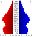
Age pyramid Robertson County
See also
 In Spanish: Condado de Robertson (Tennessee) para niños
