
Hrazdan facts for kids
Quick facts for kids
Hrazdan
Հրազդան
|
||
|---|---|---|
|
Town
|
||

From top left:
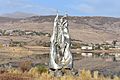
Makravank Monastery • Tsovinar monument on Aghbyurak Reservoir • Entrance monument
Palace of Culture • Music school Marmarik Reservoir • Hrazdan skyline |
||
|
||

Hrazdan
Location in Armenia
|
||
| Country | ||
| Province | Kotayk | |
| Founded | 1959 | |
| Area | ||
| • Total | 20 km2 (8 sq mi) | |
| Elevation | 1,675 m (5,495 ft) | |
| Population
(2011)
|
||
| • Total | 41,875 | |
| • Density | 2,100/km2 (5,400/sq mi) | |
| Time zone | UTC+4 (AMT) | |
| Postal code |
2301-2309
|
|
| Area code(s) | (+374) 223 | |
| Website | www.hrazdan.am | |
| Hrazdan at GEOnet Names Server | ||

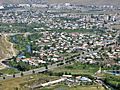
Hrazdan is a town and a community in Armenia. It is the main city of Kotayk Province. Hrazdan is about 45 kilometers (28 miles) northeast of the capital city, Yerevan.
In 2011, about 41,875 people lived there. This number is lower than in 1989, when 59,000 people lived in Hrazdan. During the time of the Soviet Union, Hrazdan was a major industrial center in Armenia.
The main church office for the Diocese of Kotayk of the Armenian Apostolic Church is located in Hrazdan.
Contents
What's in a Name?
The town of Hrazdan gets its name from the Hrazdan River. This river flows through the town from north to south.
The name Hrazdan comes from an old Persian word, Frazdān. This word is linked to Zoroastrian stories. Frazdān is the name of a lake in an ancient book called the Avesta. It talks about a war involving King Goshtasb. Armenians followed Zoroastrianism before they became Christians. So, many old Zoroastrian names stayed in Armenia's geography.
A Look at History
Early Times and Middle Ages

Hrazdan's area was part of the Kotayk region in Ancient Armenia. This was during the 1st and 2nd centuries AD. Later, between the 5th and 7th centuries, two families, the Kamsarakan and Amatuni, ruled the area. This was when Persia was in charge.
From the 7th to the 9th centuries, Armenia was under Arab rule. By the late 800s, the region became part of the new Bagratid Kingdom of Armenia. Between the 11th and 15th centuries, the area faced many invasions. These included attacks from the Seljuks, Mongols, Ag Qoyunlu, and Kara Koyunlu.
From the 1500s to the 1800s
In the early 1500s, Hrazdan became part of Persia's Erivan Beglarbegi. In the 1700s, it was part of the Erivan Khanate, still under Persian rule. This lasted until 1827-1828. Then, Eastern Armenia became part of the Russian Empire. This happened after the Russo-Persian War of 1826–28 and the Treaty of Turkmenchay.
The 1900s and Today
After the Russian Empire fell, Armenia became independent in May 1918. This was thanks to Armenian victories in battles like Sardarabad. After two years, Armenia joined the Soviet Union in December 1920.
Hrazdan is one of the towns that grew a lot during Soviet times. The old village of Akhta (or Nerkin Akhta) was the center of the Akhta region. In 1959, Akhta became a town called Hrazdan. The Akhta region was also renamed Hrazdan region.

In 1961-63, architects M. Grigoryan and E. Altunyan planned how Hrazdan would grow. On January 12, 1963, several villages like Vanatur and Makravan joined Hrazdan. This made Hrazdan a town directly under the republic's control. So, Hrazdan was formed by combining many smaller villages.

Hrazdan developed greatly in the 1960s and 1970s. The Soviet government opened many large factories. These included the "HrazdanMash" machine tool plant and a cement factory. Another plan in 1978-80 aimed for 120,000 residents by 2010. But this plan stopped when the Soviet Union broke apart.
Today, Hrazdan has three main parts:
- Northern: This includes the Jrarat and Mikroshrjan areas, plus the Hrazdan industrial zone.
- Central: This has the Kochor, Vanatur, Kentron, and Makravan areas.
- Southern: This includes Spandaryan and Aghbyurak, along with the Hrazdan reservoir.
In December 1995, Hrazdan became the main city of the new Kotayk Province.
Land and Weather

Hrazdan is in the northeastern part of Armenia, in the Kotayk Province. The Pambak mountains are to the north, and the Tsaghkunyats Mountains are to the southwest. The town's borders reach the Geghama mountains to the east, up to Mount Gutanasar. The Hrazdan River flows through the town. It is joined by the Marmarik and Aghveran rivers.
Hrazdan is about 1,675 meters (5,495 feet) above sea level. The town has a climate with warm summers and cold winters. The average temperature is 6 °C (43 °F). It can be -7 °C (19 °F) in January and 18.1 °C (64.6 °F) in August. The town gets about 700 mm (28 inches) of rain each year.
| Climate data for Hrazdan | |||||||||||||
|---|---|---|---|---|---|---|---|---|---|---|---|---|---|
| Month | Jan | Feb | Mar | Apr | May | Jun | Jul | Aug | Sep | Oct | Nov | Dec | Year |
| Record high °C (°F) | 8.0 (46.4) |
12.0 (53.6) |
20.0 (68.0) |
26.1 (79.0) |
29.0 (84.2) |
31.0 (87.8) |
35.0 (95.0) |
35.0 (95.0) |
33.0 (91.4) |
25.9 (78.6) |
20.0 (68.0) |
15.1 (59.2) |
35.0 (95.0) |
| Daily mean °C (°F) | −6.9 (19.6) |
−5.1 (22.8) |
0.3 (32.5) |
5.8 (42.4) |
10.6 (51.1) |
15.1 (59.2) |
18.1 (64.6) |
18.1 (64.6) |
14.1 (57.4) |
8.2 (46.8) |
1.1 (34.0) |
−4.5 (23.9) |
6.2 (43.2) |
| Record low °C (°F) | −26.0 (−14.8) |
−28.1 (−18.6) |
−25.6 (−14.1) |
−17.5 (0.5) |
−5.3 (22.5) |
0.0 (32.0) |
2.5 (36.5) |
2.6 (36.7) |
−3.0 (26.6) |
−9.0 (15.8) |
−20.0 (−4.0) |
−27.2 (−17.0) |
−28.1 (−18.6) |
| Average precipitation mm (inches) | 47.1 (1.85) |
57.6 (2.27) |
73.1 (2.88) |
96.7 (3.81) |
95.4 (3.76) |
61.3 (2.41) |
49.7 (1.96) |
29.4 (1.16) |
32.7 (1.29) |
57.8 (2.28) |
49.2 (1.94) |
48.6 (1.91) |
698.6 (27.52) |
| Average precipitation days (≥ 1.0 mm) | 7.9 | 8.4 | 9.5 | 13 | 14.3 | 9.3 | 6.6 | 5.5 | 4.7 | 7.6 | 6.6 | 7.4 | 100.8 |
| Source: NOAA | |||||||||||||
People and Population

| Historical population | ||
|---|---|---|
| Year | Pop. | ±% p.a. |
| 1959 | 7,630 | — |
| 1976 | 35,137 | +9.40% |
| 1989 | 25,903 | −2.32% |
| 1991 | 25,600 | −0.59% |
| 2001 | 52,808 | +7.51% |
| 2004 | 52,700 | −0.07% |
Religion
Most people in Hrazdan are Christians. They belong to the Armenian Apostolic Church. The church's local office is the Diocese of Kotayk.
Hrazdan has many churches. Some are very old, from the Middle Ages, and some are newer. The Surp Stepanos (Saint Stephen) Monastic Complex is from the 10th to 12th centuries, but it is now in ruins.
As of 2016, these churches are in the town:
- Makravank Monastery: This has two churches. One is the Holy Saviour's church from the 10th century. The other is the Holy Mother of God church from the 13th century.
- Holy Cross Church of Kochor: Built in 1854-61, and rebuilt in 2013.
- Holy Mother of God Church of Vanatur: Opened in 1883.
- Blue Cross Chapel of Vanatur: Built in 1993-96.
- Tukh Manuk Church: Opened in 2003.
- Saint George's Church: Opened in 2013.
Hrazdan also has many ruined medieval churches and monasteries. The Armenian government protects them. These include:
- Kakavadzor Upper Chapel, Hrazdan (4th-7th centuries)
- Surp Stepanos Church of Aghbyurak (10th-12th centuries)
- Holy Right Monastery (10th-14th centuries)
- Kakavadzor Chapel, Hrazdan (18th-19th centuries)
- Surp Karapet Church of Jrarat (1831)
Culture and Arts
.jpg)
_-_Cemetery_of_fallen_soldiers_in_Artsakh_(Hrazdan,_Vanatur_distr.)_02.JPG)
The Hrazdan Drama Theatre started in 1953. The Hrazdan branch of the National Gallery of Armenia is also in town. The Geological Museum of Hrazdan is another important cultural place. The History Museum in Hrazdan was started by Armen Aivazyan. It has over 4,000 old items and valuable pieces.
Media
Hrazdan TV is a local TV company in Hrazdan. It was started by the Harutyunyan family. This family also publishes a newspaper and runs a radio station called Hrazdan Radio. About 220,000 people watch Hrazdan TV. It has been broadcasting since September 1, 1991. It covers the Kotayk Province and parts of the Gegharkunik Province.
Getting Around
.jpg)
Hrazdan is a key place for travel between the capital, Yerevan, and Armenia's northern areas. The M-4 Motorway, which connects Yerevan with northern Armenia, goes through the town. As a provincial center, Hrazdan has good roads connecting it to the rest of Kotayk.
The town also has an important train station. It is on the South Caucasus Railway lines that go from Yerevan to Shorzha and from Yerevan to Dilijan.
Economy and Industry
Hrazdan is one of Armenia's most industrial towns. It has many large factories:
- Hrazdan hydroelectric power plant: This plant uses water to make electricity. It was built between 1954 and 1959. It has two large machines that can make 81.6 megawatts of power. It was designed to produce 375 GWh of electricity each year. The water reservoir covers 1.7 square kilometers (0.66 sq mi).

- Hrazdan Thermal Power Plant (RazTES OJSC): This is one of the biggest power plants in the Transcaucasia region. It was built from 1963 to 1974. The first part started working in 1966. A new part was added in 2013. The older parts are owned by Hrazdan Energy Company. The new 5th part is owned by Gazprom Armenia. The plant can produce a total of 1,110 megawatts (from units 1-4) and 480 megawatts from the 5th unit.
- Hrazdan Cement factory: This factory started in 1970. It was owned by the Soviet government. In 2001, it became a private company. In 2014, new owners took over. They made big changes to improve how cement is made and to be kinder to the environment. It is one of the largest cement makers in the region. It can produce 1.2 million tons each year.
- "Qualitech Machinery" machine tool plant: This is a company started in 1999 by Armenian and Canadian partners.

The town also has smaller factories. These include "Hidro Storm," which makes metal-plastic products. "Arjermek" and "Hakobyan" companies make building materials.
Education
Hrazdan is home to the Humanitarian Institute of Hrazdan. This university opened in 1996. It is a private school with three main study areas: law, teaching, and economics.
As of 2009, Hrazdan had 13 public schools and 13 nursery schools. There was also one school for students with special needs. The town also has several music and sports academies.
There is a research center at the Hrazdan Zoological and Botanical Garden.
Sports and Recreation
Football is the most popular sport in Hrazdan. FC Shinarar was the town's football club during the Soviet years. They played at the Hrazdan municipal stadium. However, the club closed in 1992 because of money problems.
Field hockey is also well-liked in Hrazdan. The town has Armenia's only field hockey field, which can hold 1,500 people. The Hrazdan Hockey Club sometimes plays for Armenia in different tournaments. Sos Hayrapetyan, a Soviet-Armenian player and Olympic medalist, played for this club.
Famous People from Hrazdan
- Mishik Kazaryan (1948-2020): A famous Russian-Armenian physicist. He was known for his work with lasers and optics. He won a State Prize of the USSR in science and technology in 1980.
- Armen Nazaryan (1982-): An Armenian judoka, known for his skills in judo.
See also
 In Spanish: Hrazdan para niños
Images for kids
-
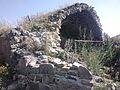
Hrazdan Caravanserai, built in the 13th century
-
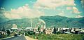
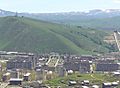
General view of Hrazdan
-
The central Kentron district
-
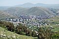
General view of Hrazdan
-
Andranik Avenue at the Vanatur district
-
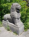
Lion statue in Hrazdan
-
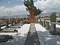
Cemetery of Artsakh war soldiers from Hrazdan
-
Hrazdan Railway Station
-

Hrazdan Thermal Power Plant
-
The statue of Tsovinar
