
Hull's Trace North Huron River Corduroy Segment facts for kids
Quick facts for kids |
|
|
Hull's Trace North Huron River Corduroy Segment
|
|

This picture shows the corduroy road section, looking north from the Harbin Drive bridge.
|
|

Location in Michigan
|
|
| Location | 36000 W Jefferson Ave, Brownstown Charter Township, Michigan |
|---|---|
| Built | 1812 |
| Architect | William Hull |
| Architectural style | Corduroy road |
| NRHP reference No. | 10001022 |
| Added to NRHP | December 13, 2010 |
The Hull's Trace North Huron River Corduroy Segment is a special part of an old military road. This road was called Hull's Trace, or sometimes Hull's Trail. It stretched from Urbana, Ohio all the way to Detroit. Hull's Trace was the very first military road and the first federal road ever built in the United States!
This particular segment is the only known piece of the original Trace that still exists today. It contains parts of a unique type of road called a corduroy road. You can find it at about 36000 W Jefferson Avenue in Brownstown Charter Township, Michigan. In 2010, this segment of Hull's Trace was added to the National Register of Historic Places. By 2014, it was made public as part of the River Raisin National Battlefield Park.
Contents
Building America's First Military Road
At the start of the War of 1812, the United States needed a way to supply Fort Detroit. This fort was important for protecting the Michigan Territory. British forces controlled Lake Erie, so supplies could not come by water. The only way was by land.
In June and July of 1812, soldiers built Hull's Trace. It was a 200-mile (320 km) military road. It ran from Urbana, Ohio, to Fort Detroit. The section of road you can see today was built on July 4, 1812. The original road had a wooden bridge over the Huron River. It also had a section of corduroy road just north of the bridge.
What is a Corduroy Road?
A corduroy road is a special type of road. It is made by laying logs side-by-side across a muddy or marshy area. This helps to make the ground firm enough for wagons and people to travel on. The corduroy construction helped make the wet soil stable for the road.
Battles Along the Trace
Hull's Trace was built close to both Lake Erie and the Detroit River. This made it easy for British forces to attack it from the water. The first land battle of the War of 1812 happened on this road. It was called the Battle of Brownstown. Later, the battles of Maguaga and Frenchtown were also fought along this important road.
The Great Military Road
After the War of 1812 ended in 1815, people realized how bad the roads were. General Andrew Jackson suggested building more military roads. In 1816, the United States Congress agreed. Troops began improving the section of Hull's Trace from Detroit to Fort Meigs. This made it the first federally supported military road in the United States.
More support for military roads grew. In 1818, Congress asked Secretary of War John C. Calhoun to plan more roads and canals. These would help with military operations during wartime. Calhoun's plan included improving Hull's Trace. The road was then renamed the "Great Military Road."
Major General Alexander Macomb led the work on the road. About 150 to 200 soldiers worked to improve it. By 1819, the road was in good shape for travel. However, it was hard to keep the road in good condition. The land was low and wet. By 1822, it was "almost impossible for wagons" to use it. A new road was built inland from 1824 to 1829.
The original Hull's Trace eventually became a regular road for people. It was an important link between Detroit and Toledo. Much of the old trace is now known as West Jefferson Avenue. The replacement road is now called River Road or US Turnpike in some areas.
What the Segment Looks Like Today
The North Huron River Corduroy Segment of Hull's Trace is found on the west side of Jefferson Avenue. It is just north of the Jefferson Avenue–Huron River Bridge.
This part of the corduroy road shows many logs. They are laid out horizontally near the water level of Silver Creek. There are about 600 logs in the exposed section. They are spread out over a distance of about 380 meters (1,247 feet). Some of the logs still have axe marks on them. The logs are all about the same size and lie next to each other.
Images for kids
-
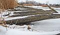
This picture was taken at the road level, looking south toward the Harbin Drive bridge.
-
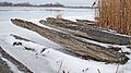
This picture was taken at the road level, looking north.
-
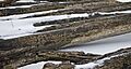
A close-up view of the logs in the old road.


