Hungry Horse, Montana facts for kids
Quick facts for kids
Hungry Horse, Montana
|
|
|---|---|

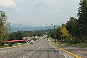
Looking east at Hungry Horse Montana on U.S. Route 2
|
|

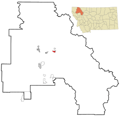
Location of Hungry Horse, Montana
|
|
| Country | United States |
| State | Montana |
| County | Flathead |
| Area | |
| • Total | 1.52 sq mi (3.94 km2) |
| • Land | 1.43 sq mi (3.71 km2) |
| • Water | 0.09 sq mi (0.23 km2) |
| Elevation | 3,097 ft (944 m) |
| Population
(2020)
|
|
| • Total | 828 |
| • Density | 577.41/sq mi (222.99/km2) |
| Time zone | UTC-7 (Mountain (MST)) |
| • Summer (DST) | UTC-6 (MDT) |
| ZIP code |
59919
|
| Area code(s) | 406 |
| FIPS code | 30-38125 |
| GNIS feature ID | 0785162 |
Hungry Horse is a small community in Flathead County, Montana, United States. It's known as a census-designated place (CDP), which means it's a special area defined by the government for counting people. In 2020, about 828 people lived there. The area's special mail code, or ZIP code, is 59919.
Contents
History of Hungry Horse
Hungry Horse started as a town when the Hungry Horse Dam was being built. The U.S. Bureau of Reclamation brought over 100 ready-made buildings to the area. These buildings were used to house the workers who were constructing the dam.
In 1948, the local government in Flathead County decided to change the town's name. It was first called "Damtown," but they renamed it Hungry Horse. The new name comes from a local story about two horses, Tex and Jerry. These horses got lost and nearly starved in deep snow near the South Fork of the Flathead River.
Geography of Hungry Horse
Hungry Horse is located in the middle of Flathead County. It sits where the Flathead River meets its South Fork. A place called Bad Rock Canyon is less than a mile west of the community.
U.S. Route 2 goes right through Hungry Horse. This road leads northeast about 10 miles (16 km) to West Glacier. It also goes southwest about 23 miles (37 km) to Kalispell. Another road, West Side Road, goes southeast from town. It leads about 4 miles (6.4 km) up the South Fork valley to the Hungry Horse Dam and its large lake.
The Hungry Horse area covers about 1.5 square miles (3.8 square kilometers). Most of this area, about 1.4 square miles (3.7 square kilometers), is land. A smaller part, about 0.09 square miles (0.23 square kilometers), is water.
People and Population
| Historical population | |||
|---|---|---|---|
| Census | Pop. | %± | |
| 2020 | 828 | — | |
| U.S. Decennial Census | |||
In 2000, there were 934 people living in Hungry Horse. These people lived in 346 households, and 237 of those were families. The population density was about 506 people per square mile (195 per square kilometer). There were 404 homes in the area.
Most of the people in Hungry Horse were White (about 94.86%). Some were Native American (about 2.14%). A small number were Asian, Pacific Islander, or from other backgrounds. About 1.71% of the population was Hispanic or Latino.
Many households (37%) had children under 18 living with them. About half of the households (50.6%) were married couples. The average household had 2.7 people, and the average family had 3.2 people.
The population had people of all ages. About 30.3% were under 18 years old. About 7.9% were between 18 and 24. The largest group, 31.3%, was between 25 and 44 years old. The median age was 35 years. In 2010, the census counted 826 people living in Hungry Horse.
Places to Visit
- Hungry Horse Dam
- Bad Rock Canyon
- International Larix Arboretum
Notable People
- Dee Brown, an American politician.
See also
 In Spanish: Hungry Horse (Montana) para niños
 | Aaron Henry |
 | T. R. M. Howard |
 | Jesse Jackson |


