Hunter County facts for kids
Quick facts for kids HunterNew South Wales |
|||||||||||||||
|---|---|---|---|---|---|---|---|---|---|---|---|---|---|---|---|

Location in New South Wales
|
|||||||||||||||
|
|||||||||||||||
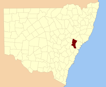
Hunter County was one of the first areas officially marked out in New South Wales, Australia. It was one of the original Nineteen Counties that were set up in the early days of the colony. Today, it is one of the 141 Cadastral divisions of New South Wales, which are like old-fashioned land districts used for mapping and property records.
This county is located between two important rivers: the Hunter River to the north and the Colo River to the south. A large part of the beautiful Wollemi National Park is found within Hunter County. To the east, you'll find the Macdonald River.
Hunter County was named to honor Governor John Hunter. He was an important person in the early history of New South Wales, serving as the second Governor from 1795 to 1800.
What are Cadastral Divisions?
Cadastral divisions are like special maps or sections of land. They were created a long time ago to help organize and keep track of land ownership. Imagine dividing a big cake into many slices so you know who owns which piece. That's a bit like what these divisions do for land.
Why were they created?
These divisions were important for the government. They helped them manage land sales, grants, and taxes. They also made it easier to describe where a piece of land was located. Even today, these old divisions are still used for some mapping and legal purposes.
Parishes in Hunter County
Counties like Hunter are further divided into smaller areas called parishes. These parishes are even smaller sections of land. They help to break down the county into more manageable parts for mapping and local administration. Each parish has its own name and specific location within the county.
 | Bayard Rustin |
 | Jeannette Carter |
 | Jeremiah A. Brown |

