Hyūga Province facts for kids

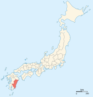
Hyūga Province (日向国 (Hyūga no kuni)) was an old part of Japan. It was located in the area that is now Miyazaki Prefecture, on the island of Kyūshū. People sometimes called it Nisshū (error: {{nihongo}}: Japanese or romaji text required (help)) or Kōshū (error: {{nihongo}}: Japanese or romaji text required (help)).
Hyūga Province shared its borders with Bungo Province, Higo Province, Ōsumi Province, and Satsuma Province. The main city, or capital, of the province was located near Saito.
Contents
History of Hyūga Province

Ancient Japanese books like the Kojiki and Nihon Shoki mention Hyūga. They sometimes called it Kumaso Province. These books also mention other nearby areas like Tsukushi, Toyo, and Hi Province.
In the year 713, Hyūga Province became a separate area. It was split off from Ōsumi Province.
Later, during the Meiji period (1868-1912), Japan changed its old provinces into new areas called prefectures. This happened in the 1870s, and Hyūga Province became part of what is now Miyazaki Prefecture.
Important Shrines and Temples
The most important Shinto shrine in Hyūga was called Tsuno jinja. It was known as the chief shrine, or ichinomiya, of the province.
Learn More About Japan's Provinces
See also
 In Spanish: Provincia de Hyūga para niños
 | Misty Copeland |
 | Raven Wilkinson |
 | Debra Austin |
 | Aesha Ash |

