
Illapel facts for kids
Quick facts for kids
Illapel
|
||||||
|---|---|---|---|---|---|---|
 |
||||||
|
||||||
| Country | ||||||
| Region | ||||||
| Province | Choapa | |||||
| Founded | 1752 | |||||
| Government | ||||||
| • Type | Municipality | |||||
| Area | ||||||
| • Total | 2,629.1 km2 (1,015.1 sq mi) | |||||
| Elevation | 388 m (1,273 ft) | |||||
| Population
(2012 Census)
|
||||||
| • Total | 30,074 | |||||
| • Density | 11.4389/km2 (29.6266/sq mi) | |||||
| • Urban | 21,826 | |||||
| • Rural | 8,529 | |||||
| Demonym(s) | Illapelino | |||||
| Time zone | UTC−4 (CLT) | |||||
| • Summer (DST) | UTC−3 (CLST) | |||||
| Area code(s) | 56 + 53 | |||||
| Climate | BSk | |||||
| Website | Official website: http://www.municipalidadillapel.cl/ | |||||


Illapel (Spanish pronunciation: [i.ʝa.ˈpel]) is a city in Chile. It is the capital of the Choapa Province in the Coquimbo Region. The city is located along the Illapel River.
Illapel is special because it marks the narrowest point of Chile from east to west. This distance is only 94 kilometers (about 58 miles). The city is found to the east of Los Vilos.
Contents
How Illapel is Governed
Illapel is a commune, which is like a local government area in Chile. It is managed by a municipal council. This council works with an alcalde, who is like a mayor. The mayor is chosen by the people in an election every four years.
Who is the Mayor of Illapel?
From 2008 to 2012, the mayor of Illapel was Denis Cortés Vargas. He was an independent politician.
How Illapel is Represented in Government
Illapel is part of a larger area for elections. This area sends people to the Chamber of Deputies, which is like one part of Chile's parliament. Adriana Muñoz and Luis Lemus represented this area.
Illapel is also part of a bigger area for the Senate. The Senate is the other part of Chile's parliament. Evelyn Matthei Fornet and Jorge Pizarro Soto represented the Coquimbo Region in the Senate.
Illapel's Population and Land Area
The National Statistics Institute took a census in 2002. This census helps us learn about the people and land in Illapel.
How Many People Live in Illapel?
In 2002, Illapel had 30,355 people living there. Out of these, 14,940 were men and 15,415 were women.
Where Do People Live?
Most people in Illapel live in urban areas, which are like cities or towns. About 21,826 people (71.9%) lived in urban areas. The rest, 8,529 people (28.1%), lived in rural areas, which are like the countryside.
How Big is Illapel?
Illapel covers a large area of 2,629.1 square kilometers (about 1,015 square miles). Between 1992 and 2002, the population grew by 4.6%. This means 1,348 more people came to live in Illapel during that time.
The Big Earthquake of 2015
On September 16, 2015, a very strong earthquake happened near Illapel. It was a magnitude 8.3 earthquake. The ground shook at 7:54 PM local time. The center of the earthquake was about 46 kilometers (28 miles) west of Illapel.
What Happened After the Earthquake?
The earthquake caused damage to buildings and sadly, some people lost their lives. About one million people living near the coast had to move to higher ground because of a tsunami warning. A tsunami is a giant ocean wave caused by an earthquake.
The warning was sent to parts of South America, Hawaii, California, and French Polynesia. After the earthquake, the price of copper went up. People worried that the earthquake might stop copper from being mined and sent out.
Images for kids
-
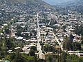
A view of Illapel
-
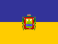
The flag of Illapel
-
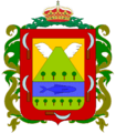
The coat of arms of Illapel
-
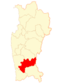
Map showing Illapel's location
See also
 In Spanish: Illapel para niños
