Ina, Illinois facts for kids
Quick facts for kids
Ina, Illinois
|
|
|---|---|

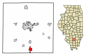
Location of Ina in Jefferson County, Illinois
|
|

Location of Illinois in the United States
|
|
| Country | United States |
| State | Illinois |
| County | Jefferson |
| Township | Spring Garden |
| Area | |
| • Total | 2.40 sq mi (6.23 km2) |
| • Land | 2.40 sq mi (6.23 km2) |
| • Water | 0.00 sq mi (0.00 km2) |
| Elevation | 427 ft (130 m) |
| Population
(2020)
|
|
| • Total | 1,641 |
| • Density | 682.33/sq mi (263.45/km2) |
| Time zone | UTC-6 (CST) |
| • Summer (DST) | UTC-5 (CDT) |
| ZIP code |
62846
|
| Area code(s) | 618 |
| FIPS code | 17-37179 |
| GNIS ID | 2398569 |
| Public Transit | South Central Transit |
| Wikimedia Commons | Ina, Illinois |
Ina is a small village located in Jefferson County, Illinois, in the United States. In 2020, about 1,641 people lived there. It is part of the larger Mount Vernon area.
Contents
Exploring Ina's Location
Ina is found in southern Illinois. A main road, Illinois Route 37, runs through the village. This road is also known as Main Street. A bigger highway, Interstate 57, passes by the west side of Ina. You can get to Ina from Exit 83 on this highway.
The city of Mount Vernon is about 11 miles (18 km) north of Ina. Mount Vernon is the main city for Jefferson County. Another town, Benton, is about 11 miles (18 km) south.
Ina covers an area of about 2.45 square miles (6.35 square kilometers). All of this area is land.
Waterways and Lakes Near Ina
Ina is built on higher ground. It sits between two creeks called Casey Creek and Gun Creek. These creeks flow into a larger river, the Big Muddy River.
The Big Muddy River has a dam built across it. This dam created a large lake called Rend Lake. Parts of Rend Lake stretch up into Casey Creek and Gun Creek.
Ina is also home to the Big Muddy River Correctional Center. This is a large facility located within the village. Rend Lake College is a school located just outside the village limits to the southwest. It has an Ina mailing address.
A Look at Ina's Past
In the 1840s, many Cherokee families came to live in Ina. They were likely seeking safety after being forced from their homes during the Trail of Tears. Because of this, people in the 1800s sometimes jokingly called Ina "the Cherokee Reservation."
The main settlement in this area used to be Spring Garden. It was about 3 miles (5 km) northeast of Ina. Spring Garden grew from 1848 onwards. However, things changed when the Chicago and Eastern Illinois Railroad was built in 1905. After the railroad arrived, people and businesses moved closer to the train stations. These stations were in Ina and a nearby town called Bonnie. This shift caused Ina to grow.
Ina's Population Over Time
| Historical population | |||
|---|---|---|---|
| Census | Pop. | %± | |
| 1900 | 317 | — | |
| 1910 | 484 | 52.7% | |
| 1920 | 398 | −17.8% | |
| 1930 | 458 | 15.1% | |
| 1940 | 501 | 9.4% | |
| 1950 | 432 | −13.8% | |
| 1960 | 332 | −23.1% | |
| 1970 | 333 | 0.3% | |
| 1980 | 460 | 38.1% | |
| 1990 | 489 | 6.3% | |
| 2000 | 2,455 | 402.0% | |
| 2010 | 2,338 | −4.8% | |
| 2020 | 1,641 | −29.8% | |
| U.S. Decennial Census | |||
The numbers for Ina's population have changed quite a bit. For example, in 2000, the official population was 2,455 people. However, this number included about 1,850 male residents from the Big Muddy River Correctional Center. If you look at just the village outside of the center, there were about 600 people.
In 2020, the population was 1,641 people.
Education in Ina
The Spring Garden School District 178 manages the schools in the area. This includes Spring Garden Elementary School. Even though it has a Mount Vernon mailing address, it is outside that city. Spring Garden Middle School is located right in Ina.
See also
 In Spanish: Ina (Illinois) para niños
 | Madam C. J. Walker |
 | Janet Emerson Bashen |
 | Annie Turnbo Malone |
 | Maggie L. Walker |

