India Basin, San Francisco facts for kids
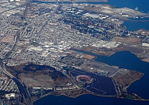
India Basin is a cool neighborhood in the southeastern part of San Francisco, California. It's named after the water body next to it. This area is part of the bigger Bayview–Hunters Point community.
Contents
History of India Basin
The story of India Basin mixes industrial work with fun open spaces. The land was once part of a huge 4,446-acre (1,799 ha) ranch. This ranch was given to José Cornelio Bernal in 1839. It was called Rancho Rincon de las Salinas y Potrero Viejo.
Early Land Sales and Access
Bernal sold the India Basin land to two developers in the late 1840s. But their plans didn't work out. Records also show Bernal sold 160 acres (65 ha) to John Hunter around 1849. Hunter wanted to build a new town called South San Francisco there. This is not the same city as South San Francisco in San Mateo County.
It was hard to get to India Basin from central San Francisco. This changed when the "Long Bridge" was finished in 1865. It was a wooden walkway built over Mission Cove. It later extended to Hunters Point in 1867.
How India Basin Got Its Name
The name India Basin first appeared in 1868. It was given by the State Board of Tide Land Commissioners. They said it was the area between Islais Creek and Hunters Point.
No one is completely sure how the name came about. The best guess is that ships from the India Rice Mill Company docked there. This happened a lot in the 1800s. Another fun idea is that fresh water from nearby springs stayed good until a ship reached India.
Butchertown: Early Industries
The area was also known as Butchertown at first. This was because many slaughterhouses and animal processing places were built there. In 1868, a group of butchers bought 81-acre (33 ha) for a "Butcher's Reservation." By 1877, all the old butcher shops near the city center moved to this new area.
At that time, the area was swampy and far away from the city. This made it easy to get rid of waste. The new slaughterhouses had slatted floors. Waste could be swept away by the bay tides twice a day. However, reports from that time said this didn't work well. People described the water as "black with decomposed blood" and smelling terrible.
Building and Development
Small boat builders also used the southern part of India Basin. They started around 1870. They moved there from Islais Creek and Potrero Point. The land was cheap, and they had deep access to the Bay.
After the 1906 San Francisco earthquake, there were plans to build houses. They would be on land reclaimed from the Bay by adding fill. But voters in Los Angeles stopped the bond that would have paid for a seawall.
Land was added between India Basin and Islais Creek starting in the 1960s. First, a debris dike was built in 1961. Then, 2,500,000 cu yd (1,900,000 m3) of Bay mud was placed inside the dike in 1964. The site was used as a landfill from 1965 to 1975. A soil cap was put on top in 1977.
In 1969, the Port of San Francisco approved plans for a new 50-acre (20 ha) LASH terminal. LASH stands for "lighter aboard ship." This terminal was for Pacific Far East Lines. It was the world's first LASH terminal and opened in 1972.
Modern Changes and Community
The Butchertown Redevelopment Plan started in the late 1960s. It aimed to fix "severe conditions of blight" in the area. The plan suggested changing the area for industrial uses. By 1975, over $22 million was spent to remove old slaughterhouses. But no new lots had been sold. So, people started to offer the site to the United States Postal Service (USPS).
Eventually, the USPS moved its San Francisco mail facility to India Basin by 1979. It took up almost half of the available land.
India Basin has a strong community. Many people are part of the India Basin Neighborhood Association (IBNA).
Where is India Basin Located?
India Basin first referred to the part of San Francisco Bay between the Hunters Point peninsula and Islais Creek. Later, the definition grew to include the neighborhood north of Ninth Avenue South (now Innes Avenue). It was bordered by Kentucky (now Third) Street and the Hunters Point Naval Shipyard. It stretched from the top of the hill to the water.
It is just north of the Bayview neighborhood. It is south of the Pier 90–96 cargo terminal. This terminal includes the LASH shipping facility. There is also an undeveloped area within Piers 90–96 called the Pier 90–94 Backlands.
The Butchertown/India Basin neighborhood became part of Bayview–Hunters Point around 1938. This was before World War II. At that time, the United States Navy took over the Bethlehem Steel Hunters Point Dry Docks.
Parks and Green Spaces
India Basin has several parks and shoreline areas. These include Heron's Head Park, Youngblood-Coleman Playground, and India Basin Shoreline Park. There are also undeveloped areas that might become parks. These include the Hunters Point shoreline, where the Hunters Point Power Plant once stood. Other areas are 900 Innes, India Basin Open Space / The Big Green / 700 Innes, and Northside Park.
India Basin Shoreline Park
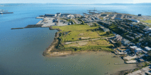
The India Basin Shoreline Park Natural Area is next to Hunters Point Boulevard. It is right on the shore of San Francisco Bay. India Basin is the only Natural Area in the San Francisco Recreation and Park Department (SFRPD) system that touches the Bay.
The natural area is in the park's southern part. It covers about 6.2 acres (25,000 m2) of the total 11.8 acres (48,000 m2) park. Only the southern third of the park is considered a Natural Area.
Why India Basin Park is Special
Since it's the only Natural Area next to the Bay, India Basin is very special. It has unique natural resources and great places for fun. You can use the Bay Trail for walking or biking. You can also access the Bay for fishing, kayaking, and other water sports.
The park also has one of the few tidal salt marsh wetlands in the city. This is a good home for many shore birds. Birds of prey also come here to hunt. Plus, you get amazing views of the San Francisco Bay!
In 2016, the San Francisco Parks Alliance and Build Inc. held a contest. They wanted ideas for a new 7.5-acre park on the India Basin Shoreline. A company called GGN (Gustafson Guthrie Nichol) won. Their plan focused on a softer shoreline and connecting to the neighborhood. The park is designed to be a part of the local culture. It will offer access, recreation, and natural habitats.
 | Anna J. Cooper |
 | Mary McLeod Bethune |
 | Lillie Mae Bradford |


