Indian Creek (Mauses Creek tributary) facts for kids
Quick facts for kids Indian Creek |
|
|---|---|

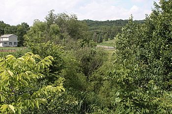
Vegetation near Indian Creek
|
|
| Physical characteristics | |
| Main source | valley in Derry Township, Montour County, Pennsylvania 840 to 860 feet (260 to 260 m) |
| River mouth | Mauses Creek in Valley Township, Montour County, Pennsylvania 489 ft (149 m) 40°59′41″N 76°38′38″W / 40.99461°N 76.64392°W |
| Length | 2.6 mi (4.2 km) |
| Basin features | |
| Progression | Mauses Creek → Mahoning Creek → Susquehanna River → Chesapeake Bay |
| Basin size | 1.92 sq mi (5.0 km2) |
Indian Creek is a small stream in Montour County, Pennsylvania. It is also known as Indian Run or Indian Run Creek. This creek flows into Mauses Creek. It is about 2.6 miles (4.2 km) long. The area of land that drains into Indian Creek, called its watershed, is about 1.92 square miles (5.0 km2).
The water in Indian Creek is clean. The Pennsylvania Department of Environmental Protection says it is not "impaired." This means the water quality is good. Near where it joins Mauses Creek, Indian Creek is about 489 feet (149 m) above sea level. A major highway, Interstate 80, crosses over the creek.
Contents
Where Does Indian Creek Flow?
Indian Creek starts in a valley. This valley is located near the southern part of Derry Township. The creek flows south for a short distance. Then it enters Valley Township.
After entering Valley Township, the creek turns southwest. It flows in this direction for a while. It then turns south-southwest and passes through a small pond. Finally, it turns south again. It flows under Interstate 80 and Pennsylvania Route 54. Soon after crossing these roads, Indian Creek meets Mauses Creek. This meeting point is about 1.20 miles (1.93 km) upstream from the mouth of Mauses Creek.
How Clean is Indian Creek's Water?
The water in Indian Creek is very clean. The Pennsylvania Department of Environmental Protection has checked it. They say that no part of Indian Creek or its smaller streams are "impaired." This means the water is healthy.
Scientists study how water flows in the creek. They use something called a "runoff curve number." In 2010, this number was 60.3 for Indian Creek. It helps them understand how much rainwater flows into the creek. They also look at "stormwater lag time." This is how long it takes for a storm's water to reach the creek. In 2010, it was 66.9 minutes.
What is Indian Creek's Landscape Like?
Indian Creek is about 489 feet (149 m) above sea level near its mouth. The very beginning of the creek, called its headwaters, is higher up. It is between 840 feet (260 m) and 860 feet (260 m) high.
Along Indian Creek, there are 82 spots that scientists call "disturbances." These are places where the creek's natural shape has been changed. For example, 24 of these spots are where the land is eroding. This means the soil is washing away. Some erosion spots are on the creek's left side, and some are on its right side.
Other "disturbances" include 10 sand or gravel bars. These are places where sediment has built up. There are also 9 bridges that cross the creek. Six spots have pipes, and six have riprap. Riprap is a layer of rocks used to prevent erosion. There are also two smaller streams that flow into Indian Creek. One spot has a concrete wall, and another is a place where horses cross the creek.
Indian Creek's Watershed and History
The land area that drains into Indian Creek is called its watershed. This watershed covers about 1.92 square miles (5.0 km2). Within this area, there are about 4.3 miles (6.9 km) of streams in total.
Indian Creek can sometimes cause flooding in Valley Township. This means that after heavy rains, the creek can overflow its banks.
Two bridges were built over Indian Creek in 1963. These bridges carry Interstate 80. Each bridge is about 214.9 feet (65.5 m) long. A road runs along the side of Indian Creek for some distance. Another road, Township Road 371, also crosses the creek. This road was once replaced in a big project that cost $1,120,000.
Plants and Nature Along Indian Creek
The areas along the banks of Indian Creek are important for nature. Three of the creek's banks are covered in plants for more than 60 percent of their length. Other banks have less plant cover. For example, 11 banks are between 30 and 60 percent covered. And 10 banks have less than 30 percent plant cover.
There are also riparian buffers along the creek. These are strips of plants and trees along the banks. They help protect the water quality and provide homes for animals.
The Montour County Natural Areas Inventory is a group that studies natural places. They say that Indian Creek is "of ecological value." This means it is an important natural area.
 | Mary Eliza Mahoney |
 | Susie King Taylor |
 | Ida Gray |
 | Eliza Ann Grier |

