
Mahoning Creek (Susquehanna River tributary) facts for kids
Quick facts for kids Mahoning Creek |
|
|---|---|

Mahoning Creek
|
|
_satellite_map.PNG)
Satellite map of Mahoning Creek. The red dot is the stream's source and blue dot is its mouth.
|
|
| Physical characteristics | |
| Main source | valley in Madison Township, Columbia County, Pennsylvania between 1,080 and 1,100 feet (330 and 340 m) |
| River mouth | Susquehanna River in Danville, Montour County, Pennsylvania 463 ft (141 m) 40°57′54″N 76°37′54″W / 40.9649°N 76.6316°W |
| Length | 10.6 mi (17.1 km) |
| Basin features | |
| Progression | Susquehanna River → Chesapeake Bay |
| Basin size | 39.6 sq mi (103 km2) |
| Tributaries |
|
Mahoning Creek is a stream in Pennsylvania, USA. It flows into the Susquehanna River. The creek is about 10.6 miles (17.1 km) long. It runs through parts of Columbia County and Montour County. The area of land that drains into the creek, called its watershed, is 39.6 square miles (103 km2).
Mahoning Creek has smaller streams that flow into it. These are called tributaries. Its main tributaries are Kase Run, Mauses Creek, and Sechler Run. Parts of Mahoning Creek are good for fishing. It is known as a place where trout are stocked. It is also a place where fish travel to lay their eggs.
The Pennsylvania Department of Environmental Protection says that Mahoning Creek has some problems. It is affected by too much siltation, which means fine dirt and sand are building up. The land around the creek has different types of rocks and soils. Most of the land is covered by forests or farms. Some areas are developed with buildings and roads.
Long ago, a village of the Delaware tribe was near where Mahoning Creek meets the Susquehanna River. The first European settlers came to this area in the 1760s and 1770s. People built many mills along the creek in the 1700s and 1800s. Many bridges have also been built over the creek over time.
Contents
The Creek's Path

Mahoning Creek starts in a valley in Madison Township, Columbia County. It flows south for a short distance. Then it turns to flow west-southwest. After a short journey, it leaves Columbia County.
Next, Mahoning Creek enters West Hemlock Township in Montour County. It flows south-southwest next to Pennsylvania Route 642 for a few miles. Then it crosses the road and enters Derry Township. The creek then turns south for a few miles. After that, it enters Valley Township. In Valley Township, it keeps flowing south in its valley. It crosses Pennsylvania Route 642 again.
The creek eventually enters a wider valley. It flows away from Pennsylvania Route 642. After a bit, it crosses Interstate 80. Here, Kase Run joins it from the left side. The creek then winds west for a short distance. It turns southwest and flows next to Pennsylvania Route 642 again. Near Mausdale, Mahoning Creek crosses Pennsylvania Route 642 and Pennsylvania Route 54. Mauses Creek joins it from the right side.
The creek then turns southeast. It starts flowing next to Pennsylvania Route 54. It goes through a narrow passage in Montour Ridge. It enters Danville and leaves the narrow passage. It turns south-southwest and crosses US Route 11. After a short distance, Sechler Run joins it from the left. This is its last named tributary. The creek then turns west-northwest. After a short distance, it leaves Danville. It enters Mahoning Township briefly. Then it turns sharply southeast and reenters Danville. After a short journey, the creek meets the Susquehanna River.
Mahoning Creek joins the Susquehanna River about 136.26 miles (219.29 km) upstream from the Susquehanna's mouth.
Smaller Streams Joining Mahoning Creek
Mahoning Creek has three main smaller streams that flow into it. These are Kase Run, Mauses Creek, and Sechler Run. There are also other smaller streams that don't have names. In total, there are 92 miles of streams in the area that drains into Mahoning Creek. Most of these stream miles (90) are in Montour County. Only two miles are in Columbia County.
The area that drains into Sechler Run is 7.76 square miles (20.1 km2). Mauses Creek joins Mahoning Creek about 3.00 miles (4.83 km) before Mahoning Creek ends. The area that drains into Mauses Creek is 11.40 square miles (29.5 km2). Kase Run joins Mahoning Creek about 4.70 miles (7.56 km) before its end. The area that drains into Kase Run is 7.27 square miles (18.8 km2).
Water Quality
Mahoning Creek carries a lot of sediment (dirt and sand) and phosphorus (a nutrient). The creek has problems with too much stormwater flowing into it. This water carries dirt and pollution from farms and towns.
The Pennsylvania Department of Environmental Protection says that parts of Mahoning Creek are polluted. This pollution is mainly caused by siltation. The sources of this siltation are agriculture (farms) and urban runoff (water flowing off city streets). Some parts of its smaller streams (tributaries) are also polluted. Their pollution also comes from siltation caused by farming.
On average, about 39.3 inches (100 cm) of rain falls in the Mahoning Creek watershed each year.
Land and Rocks Around the Creek

The elevation near where Mahoning Creek meets the Susquehanna River is 463 feet (141 m) above sea level. Near where the creek starts, the elevation is between 1,080 and 1,100 feet (330 and 340 m) above sea level. The highest parts of the land that drains into the creek are in the east. The Mahoning Creek watershed is in a region with many ridges and valleys.
The rocks in the higher parts of the watershed are mostly sedimentary rock. These are rocks formed from layers of sand, mud, or other materials. The most common rock types include the Trimmers Rock Formation and the Clinton Group. The Catskill Formation is found in a large area in the northeast.
The most common type of soil series in the Mahoning Creek watershed is the Berks-Weikert-Alvira series. This soil is a shaly silt loam. Other soil types include the Chenango-Pope-Holly series and the Leck Kill-Meckesville-Calvin series.
Mahoning Creek flows through Montour Ridge. It has a forested area next to it in Mahoning Township that can flood. Some parts of the creek's banks are wearing away due to erosion.
The Mahoning Creek Watershed

The watershed of Mahoning Creek covers an area of 39.6 square miles (103 km2). A watershed is all the land where water drains into a particular river or stream. This watershed mostly covers the central part of Montour County. A small part of it is in nearby Columbia County. The watershed makes up about 30 percent of Montour County's total area. Mahoning Creek drains the land around the town of Danville.
Almost half of the watershed (47.15 percent) is covered by forests. About 36.47 percent of the land is used for farming. The remaining 16.38 percent is developed land, meaning it has buildings and roads. Most of this developed land is "low-intensity," like suburban areas. There are also about 7.4 acres of wetlands in the watershed.
Much of the land near where Mahoning Creek meets the Susquehanna River is developed. There is also a strip of developed land that crosses the middle of the watershed. The southern part of the watershed is mostly farmland. North of that, there is an area that is mostly forest. The central part is mostly farmland. The northern part has both forests and farms. The area around Mahoning Creek is seeing the fastest development in Montour County.
Major roads like Interstate 80, Pennsylvania Route 54, Pennsylvania Route 642, and US Route 11 run through the watershed. There are also many local roads near the creek and its smaller streams.
History and Name
Mahoning Creek was officially added to the Geographic Names Information System on August 2, 1979. The word "mahoning" comes from a Native American language. It means "at the lick," which refers to a place where animals would lick salt from the ground.
A village of the Delaware Indians used to be located near where Mahoning Creek flows into the Susquehanna River. One of the first buildings in Danville was a gristmill (a mill for grinding grain). It was built on Mahoning Creek by George Montgomery's father. The famous Penn family once owned a large piece of land in Danville, including an area along the creek. Early settlers like Phillip Maus arrived in the area in the late 1760s. Robert Curry settled on Mahoning Creek in 1772.
The first woolen mill in Danville was also built on Mahoning Creek. A farming fair was held along the creek in February 1856. Phillip Maus also built a sawmill on Mahoning Creek. This sawmill helped a lot in building many wooden structures nearby.
Many bridges have been built over Mahoning Creek over the years. For example, a concrete bridge was built in 1930. Several bridges for Interstate 80 were built in the 1950s and 1960s. More bridges were constructed in the 1970s and 1990s.
There is a group called the Mahoning Creek Watershed Association. It is one of two active groups in Montour County that work to protect local watersheds. This association has studied the creek and measured its water quality. They have also worked on a plan to help restore the creek's health.
Wildlife and Plants
Mahoning Creek is a good place for fish. From its start down to the Pennsylvania Route 54 bridge, it is a "Trout-Stocked Fishery" and a "Migratory Fishery." This means trout are added there, and fish travel through it. From that bridge to its mouth, it is a "Warmwater Fishery" and a "Migratory Fishery." The smaller streams that flow into Mahoning Creek (Sechler Run, Mauses Creek, and Kase Run) are "Coldwater Fisheries." This means they are cold enough for fish like trout to live there naturally.
Wild trout naturally reproduce in Mahoning Creek. This happens from its source down to the US Route 11 bridge, a distance of about 9.19 miles (14.79 km). It is one of only two streams in Montour County where wild trout reproduce. In the 1820s, large shad, salmon, and rockfish were found in the creek. Some of these fish could weigh many pounds.
Eight types of birds live in the areas that flood near Mahoning Creek and on the nearby slopes. These include scarlet tanagers, black-throated green warblers, and belted kingfishers. You might also see gray catbirds, black-capped chickadees, and eastern wood-peewees. Louisiana waterthrushes and wood thrushes also live there.
Mahoning Creek sometimes lacks a riparian buffer. This is a strip of plants along the bank that helps protect the water. However, the Mahoning Creek floodplain and nearby slopes are important natural areas. Eastern hemlock trees grow on the slopes. Trees like river birch, silver maple, and silky dogwood grow in the floodplain. American basswood also grows near the creek. Many spring wildflowers grow here too. This area has a high variety of plants. However, an insect called the hemlock wooly adelgid affects many hemlock trees.
Five types of shrubs grow near Mahoning Creek and its floodplain. These include smooth alder, silky dogwood, gray dogwood, spicebush, and American elderberry. There are also 11 types of herbs, such as skunk cabbage, bloodroot, and sensitive fern. Unfortunately, some invasive plants are also found here. These include multiflora rose, Japanese knotweed, and garlic mustard.
Images for kids
-
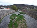
Mahoning Creek
-
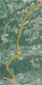
Satellite map of Mahoning Creek. The red dot is the stream's source and blue dot is its mouth.
-
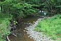
Mahoning Creek near West Mahoning Street in Danville
-
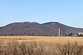
Montour Ridge, which Mahoning Creek cuts through
-
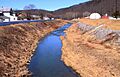
Mahoning Creek downstream of Kase Run
