Indianapolis Park and Boulevard System facts for kids
Quick facts for kids |
|
|
Indianapolis Park and Boulevard System
|
|

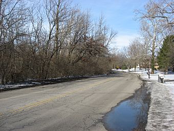
E. Pleasant Run Parkway South Drive viewed from 16th Street
|
|
| Lua error in Module:Location_map at line 420: attempt to index field 'wikibase' (a nil value). | |
| Location | Roughly bounded by 38th Street and Emerson, Southern, and Tibbs Avenues, extending on Fall Creek and Pleasant Run Parkways to Shadeland Avenue in Indianapolis, Indiana |
|---|---|
| Area | 3,474 acres (1,406 ha) |
| Built | 1898 |
| Architect | George Edward Kessler; Lawrence Sheridan |
| Architectural style | Beaux Arts, City Beautiful |
| NRHP reference No. | 03000149 |
| Added to NRHP | March 28, 2003 |
The Indianapolis Park and Boulevard System is a special network of parks, parkways, and boulevards in Indianapolis, Indiana. It was designed by a famous landscape architect named George Edward Kessler in the early 1900s. This system is also known as the Kessler System. It covers about 3,474 acres (1,406 ha) and has greatly shaped the city over the years. This important historic area was added to the National Register of Historic Places in 2003.
Contents
What Makes Up the Park System?
The Indianapolis Park and Boulevard System includes many different parts. It covers about 3,474 acres (1,406 ha). The main area is roughly between 38th Street and Emerson, Southern, and Tibbs Avenues. It also stretches along Fall Creek and Pleasant Run Parkways to Shadeland Avenue.
Parks in the System
There are twelve parks within these boundaries. They cover more than 1,118 acres (452 ha) and are important parts of the system.
- Riverside Park is one of the largest. It includes golf courses like South Grove and Coffin.
- Garfield Park and Brookside Park are also big parks in the plan.
- Smaller neighborhood parks include Rhodius Park and Willard Park.
- Even smaller parks are Fletcher Park, Highland Park, Indianola Park, McCarty Triangle Place, and Noble Place.
- University Park and Military Park in downtown Indianapolis are also part of the system. These two parks were already listed on the National Register of Historical Places before the whole system was added.
Some other parks are part of the parkways themselves:
- Spades Park is part of Brookside Parkway.
- Fall Creek and 16th, Watkins, Barton, Fall Creek and 30th parks, and Woolens Gardens are along Fall Creek Parkway.
- Orange, Christian, and Ellenberger parks, along with Pleasant Run Golf Course, are part of Pleasant Run Parkway.
Parkways and Boulevards
The system includes six parkways that stretch for 34.8 miles (56.0 km). They cover 2,153.5 acres (871.5 ha) and connect the different parks and main city streets.
- Fall Creek Parkway runs from I-465 to the White River.
- White River Parkway goes from 38th Street to where Pleasant Run joins the river.
- Brookside Parkway connects Brookside Park to Fletcher Park.
- Pleasant Run Parkway extends from Shadeland Avenue to the White River.
- Ellenberger and Burdsal are also important parkways.
Two boulevards are also part of this system:
- Maple Road, now called 38th Street, runs from Fall Creek to the White River.
- Kessler Boulevard goes from 38th to 56th Street and from Cooper Road to Fall Creek Parkway.
Bridges and Structures
The district features many beautiful stone bridges. These bridges cross Fall Creek, the White River, and other smaller streams. Some carry busy streets, like the Capitol Avenue and Meridian Street bridges over Fall Creek. Others are smaller, like the footbridge in Brookside Park.
The historic district has 29 important sites, 20 buildings, 109 structures (not buildings), and 7 other objects. Most of the buildings are inside the parks. However, some, like the Heslar Naval Armory near Riverside Park, are not.
History of the Park System
For many years, Indianapolis didn't have many organized parks. People could easily access open fields and natural areas nearby. But as the city grew, people wanted more green spaces.
Early Ideas for Parks
In 1864, the city started to manage state-owned parks like Military Park and University Square. Before this, the city had turned down offers of land for parks.
The city bought land for Brookside Park in 1870 and Garfield Park in 1873. However, these parks were not developed until the 1880s. Citizens and the city then began to improve them.
In 1894, the Commercial Club, which later became the Chamber of Commerce, hired Joseph Earnshaw. He was a landscape architect who suggested building a boulevard with parks along the White River and Fall Creek. But this plan was thought to be too expensive.
The next year, in 1895, the Parks Board hired John Charles Olmsted. His plan was similar to Earnshaw's. It focused on waterways, boulevards, and both small and large parks. However, people in the south and east parts of the city didn't like it. They felt they would be taxed for parks they wouldn't use. A new law for parks was passed in 1899, but the debate continued.
Even with the disagreements, Mayor Thomas Taggart helped the city buy 1,100 acres (450 ha) of land in the early 1900s. This included much of what became Riverside Park. Boulevards along the streams also began to be built during this time.
George Kessler's Vision
By 1907, the Parks Board realized they needed a new, complete plan. From 1908 to 1915, they hired George Edward Kessler. Kessler was already famous for his park plans in other cities like Kansas City, Missouri.
In 1909, after a year of studying Indianapolis, Kessler presented his Park and Boulevard Plan. This plan mixed the ideas of the City Beautiful Movement with practical uses. The City Beautiful Movement aimed to make cities more beautiful and orderly. Kessler also helped pass a new state law that allowed the Parks Board to collect taxes for buying and improving parks.
Kessler's plan included many ideas from earlier plans, like parks and boulevards along the White River and Fall Creek. But his plan was much bigger. It included all the public open land in the city. Parkways would follow the city's four main waterways: White River, Fall Creek, Pleasant Run, and Pogue's Run. These parkways used the natural beauty of the winding streams and wooded areas. Besides looking nice, the parkways also helped prevent water pollution and controlled floods. Kessler's plan also connected the boulevards to major city streets, like Meridian Street and 38th Street. These streets were also made more beautiful.
The decorative stone bridges over the White River and Fall Creek were a key part of Kessler's plan. Some of these bridges were built before his plan, but Kessler himself designed a new bridge on Capitol Avenue over Fall Creek.
By including all parts of the city, Kessler was able to get rid of many objections from residents. The 1909 law he supported also allowed different tax rates for different parts of the city. This depended on how much park improvement was happening in each area.
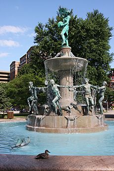
Kessler and his team designed several parks within his plan. These included University Park in 1914, Garfield Park in 1915, and Riverside Park in 1916. Kessler gave each major park its own unique feel. For example, he designed formal sunken gardens for Garfield Park. He kept the large groups of trees in Ellenberger Park. He also suggested a large central fountain for University Park.
Kessler's plan quickly started to make a difference. For example, Dr. Henry Johnson, who led the Park Board, convinced St. Vincent Hospital to move their new building. This created space for the boulevard along Fall Creek.
Kessler's successful plan for Indianapolis led other Indiana cities to hire him. His plans for Fort Wayne, South Bend, and Terre Haute also used the City Beautiful ideas.
In 1922, the Park Board hired Kessler again to design more boulevards in the northern part of the city. He suggested a wide boulevard connecting Fort Benjamin Harrison to the northwest side. Construction began, but Kessler passed away in March 1923 in Indianapolis. To honor his important work, the city named the new parkway Kessler Boulevard after him.
After Kessler's Time
By the time Kessler died in 1923, much of his plan was already built. Lawrence Sheridan, a city planner, continued to carry out Kessler's plan for many years. In 1928, Sheridan suggested an even bigger plan for parks and parkways throughout Marion County. However, most of these extra additions were never built.
Some long parts of Kessler's parkways were not finished until the 1930s. During this time, projects like the Federal Emergency Relief Administration and the Works Progress Administration helped complete Fall Creek Parkway, Pleasant Run Parkway, Riverside Drive, and Kessler Boulevard.
Recent Years
Over time, some parts of the park system started to show their age. In the 1970s, Fletcher Park, a small park, was given to a company. When the company closed, the park became neglected. In 2013, a neighborhood group took over. They plan to restore the park, bringing back historical features like a central fountain.
In the 1990s, the sunken gardens in Garfield Park were greatly improved. The Indy Greenways plan has also brought new attention to the parkways by creating trails, like the Pleasant Run Trail. In 2003, the city officially recognized the importance of the Kessler System. They worked to document the entire 3,400-acre (1,400 ha) system. This led to it being placed on the National Register of Historic Places as a historic district.
Kessler's plan continues to influence how Indianapolis develops today. The parkways and boulevards helped make the northern and eastern parts of town very popular places to live. One of Kessler's ideas was for a public area with buildings and green space leading from the Indiana State House to the White River. This idea came to life about 80 years later with the building of the Indiana Government South Building and the creation of White River State Park.
 | Isaac Myers |
 | D. Hamilton Jackson |
 | A. Philip Randolph |


