Fall Creek (Indiana) facts for kids
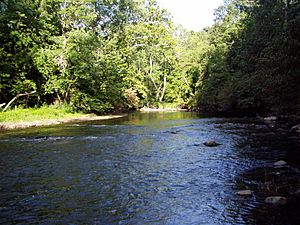
Fall Creek is a cool waterway in the state of Indiana, USA. It's like a smaller river that flows into a bigger one, the White River. Fall Creek is about 57.5 miles (92.5 km) (that's around 92.5 kilometers) long. It gathers water from an area of about 318 square miles (820 km2) in central Indiana before joining the White River in Indianapolis.
As Fall Creek winds its way southwest, it gives its name to three different areas called townships in Indiana. You'll find Fall Creek Townships in Henry County, Madison County, and Hamilton County.
Contents
Where Fall Creek Begins
Fall Creek starts its journey near a small town called Honey Creek, Indiana. At first, it flows north and even goes a little bit into Delaware County, Indiana. Here, it's close to another small stream called Bell Creek.
After a short distance, Fall Creek makes a sharp turn and heads southwest. It flows past towns like Middletown. Along the way, other smaller streams, like Honey Creek and Sugar Creek, join Fall Creek in Henry County.
Journey Through Madison County
As Fall Creek continues its path, it enters Madison County. Here, it meets up with another stream called Sly Fork in an area known as Adams Township.
Fall Creek Park and Its History
In the town of Pendleton, Fall Creek joins Prairie Creek. This area is home to the beautiful Fall Creek Park, which covers about 150 acres (610,000 m2) (that's about 607,000 square meters).
Fall Creek was actually named because of the pretty waterfalls found near Pendleton. Inside the park, you can see three small waterfalls that appear one after another. In some spots, the creek gets wide and shallow, so you can almost walk across it! After Pendleton, Fall Creek is joined by two more streams: Fosters Branch and Lick Creek.
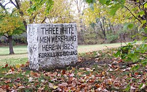
This area is also important in history. In 1824, a sad event known as the Fall Creek Massacre happened here. It was a very important moment in the history of justice for Native Americans in the United States.
Flowing Through Hamilton and Marion Counties
Just after leaving Madison County, Fall Creek crosses into Hamilton County. Here, Lick Creek joins it.
Geist Reservoir
Fall Creek flows through the southeast part of Hamilton County and fills up a large body of water called Geist Reservoir. This reservoir is held back by a dam located in Marion County. Many other streams also flow into Fall Creek in Hamilton County, including Flatfork Creek, Thorpe Creek, Thor Run, Mount Zion Branch, Bee Camp Creek, and Bills Branch.
Fall Creek in Indianapolis
After leaving Geist Reservoir, Fall Creek continues its journey. It flows right through Fort Harrison State Park. This park has nice walking trails where you can follow the creek's path and enjoy nature.

Beyond the park, a paved trail follows Fall Creek through the city of Indianapolis. The creek is dammed again in Indianapolis, near Keystone Avenue.
Meeting the White River
In downtown Indianapolis, Fall Creek actually crosses over the Indiana Central Canal. Finally, it empties into the White River near 10th Street and White River Parkway. This spot is close to the campus of Indiana University-Purdue University Indianapolis and the Veterans Administration hospital.
Indianapolis was planned to be located near where Fall Creek and the White River meet. This was because Fall Creek could provide power for early factories and businesses in the city.
Water Flow and Old Names
Scientists measure how much water flows in Fall Creek. At a station near 16th Street in Indianapolis, the creek usually carries about 345 cubic feet of water every second. That's a lot of water!
Long ago, Native American tribes had their own names for Fall Creek. In the Miami Language, it was called "Chank-tun-onn-gi." In the Delaware Language, it was known as "Sokpehllak."
 | Isaac Myers |
 | D. Hamilton Jackson |
 | A. Philip Randolph |


