
Inishbofin, County Donegal facts for kids
|
Native name:
Inis Bó Finne
|
|
|---|---|

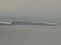
Inishbofin as seen from Machaire Rabhartaigh, with Tory Island visible in the distance, October 2011
|
|

Inishbofin
Location in island of Ireland
|
|
| Geography | |
| Location | Atlantic Ocean |
| Coordinates | 55°10′23″N 8°10′08″W / 55.17306°N 8.16889°W |
| Area | 1.2 km2 (0.46 sq mi) |
| Administration | |
| Province | Ulster |
| County | Donegal |
| Demographics | |
| Population | 11 (2011) |
Inishbofin (which means Island of the White Cow in Irish) is a small island. It is located off the coast of Machaire Uí Rabhartaigh (Magheraroarty) in County Donegal, Ireland. This quiet island is known for its beautiful views of the Atlantic Ocean.
Exploring Inishbofin's Landscape
Inishbofin is about 120 hectares (300 acres) in size. That's like 300 football fields! People on the island have traditionally made a living from fishing and farming. The Irish language is spoken regularly here.
There are no shops or pubs on Inishbofin, making it a very peaceful spot. You can get to and from the island by boat, but there isn't a regular ferry service.
Nearby Islands
Inishbofin is the largest of a small group of islands. The other islands are called Inis Dúiche and Inis Beag. They are located to the north of Inishbofin. These smaller islands are not lived on by people.
Inishbofin's Population
The number of people living on Inishbofin has changed a lot over the years. In 1911, there were 166 people living there. By 2011, the population had dropped to just 11 people.
| Historical population | |||||||||||||||||||||||||||||||||||||||||||||||||||||||||||||||||||||||||||||||||||
|---|---|---|---|---|---|---|---|---|---|---|---|---|---|---|---|---|---|---|---|---|---|---|---|---|---|---|---|---|---|---|---|---|---|---|---|---|---|---|---|---|---|---|---|---|---|---|---|---|---|---|---|---|---|---|---|---|---|---|---|---|---|---|---|---|---|---|---|---|---|---|---|---|---|---|---|---|---|---|---|---|---|---|---|
|
|
|
|||||||||||||||||||||||||||||||||||||||||||||||||||||||||||||||||||||||||||||||||
| Source: | |||||||||||||||||||||||||||||||||||||||||||||||||||||||||||||||||||||||||||||||||||
The numbers in the table come from a book called Discover the Islands of Ireland. They also use information from the official Census of Ireland. Before 1841, the census information in Ireland was not always complete or reliable.
Gallery
- Images of Inishbofin
-
Inishbofin as seen from Tory Island
-
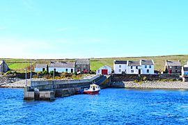
The harbour
-
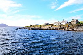
A view of Inishbofin
-
Landing at Inishbofin


