Initial Point of Boundary Between U.S. and Mexico facts for kids
Quick facts for kids Initial Point of Boundary Between U.S. and Mexico |
|
|---|---|

The monument in a 1974 photo
|
|
| Location | S of Imperial Beach off Monument Rd., Imperial Beach, California |
| Area | 0.1 acres (0.040 ha) |
| Built | 1851 |
| Governing body | Federal |
| Designated | September 6, 1974 |
| Reference no. | 74000550 |
| Lua error in Module:Location_map at line 420: attempt to index field 'wikibase' (a nil value). | |
The Initial Point of Boundary Between U.S. and Mexico (also called Monument No. 258) is a special marker. It shows where the border between the United States and Mexico begins on the western side. This monument marks the southwestern corner of the mainland United States.
This important spot was decided by the Treaty of Guadalupe Hidalgo in 1848. The treaty said the border should start about three nautical miles south of San Diego Bay. From there, the border goes in a straight line towards where the Colorado River and Gila River meet.
The monument has a message carved into its side. It says: "Initial point of Boundary between the United States and Mexico, established by the Joint Commission, 10 October, A.D. 1849, Agreeably to the Treaty dated at the City of Guadalupe, Hidalgo, February 2, A.D. 1848. John B. Weller, U.S. Commissioner. Andrew B. Gray, U.S. Surveyor." This inscription explains that the monument was set up by a special group on October 10, 1849. It followed the rules of the treaty signed in Guadalupe Hidalgo on February 2, 1848.
Contents
History of the Border Monument
The very first border marker was a pile of rocks. It was put there in 1849 after the Treaty of Guadalupe Hidalgo was signed. This treaty officially ended the war between the U.S. and Mexico.
Building the First Monument
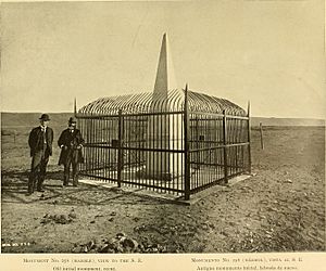
A white marble monument was made in New York. It traveled a very long way by ship around Cape Horn to San Diego. In June 1851, it was set up in Imperial Beach, California. This marble monument was like a tall, pointed pillar, about 20 feet (6 meters) high. It stood on a marble base. On top, it had an upside-down acorn shape. This acorn was a symbol of the strength of the California live oak tree.
Repairing the Monument
By 1894, the original monument had been damaged by visitors. Its shape was almost gone, and the words carved on it were hard to read. The Barlow-Blanco Commission took action. They had the monument fixed in San Diego. Then, it was rebuilt at its original spot in 1894. They also put a fence around it to protect it. As of 1974, the marble monument, rebuilt in 1894, was still standing in its place. It had only normal wear and tear and a little bit of damage from people.
Border Field State Park

In August 1971, President Richard Nixon started a program called "Legacy of Parks." As part of this, Mrs. Pat Nixon gave over 372 acres (151 hectares) of extra Navy land to California. This land was once known as Border Field. Today, it is a beach park called Border Field State Park. It's a place where people can enjoy the outdoors.
Changes to Border Access
Before 1994, the border fence between the U.S. and Mexico went right through the monument. In 1994, it became harder to reach the monument from the U.S. side. This was due to a border security plan called Operation Gatekeeper.
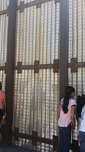
Today, the border fence is a few feet north of the monument. This means you can walk all the way around the monument from the Mexican side. It's a popular spot in Playas de Tijuana, Mexico.
See also
 In Spanish: Punto de inicio de la frontera entre Estados Unidos y México para niños
 | Tommie Smith |
 | Simone Manuel |
 | Shani Davis |
 | Simone Biles |
 | Alice Coachman |


