Innisfree, Alberta facts for kids
Quick facts for kids
Innisfree
|
|
|---|---|
|
Village
|
|
| Village of Innisfree | |
| Country | Canada |
| Province | Alberta |
| Region | Central Alberta |
| Census Division | No. 10 |
| Municipal district | County of Minburn No. 27 |
| Incorporated | |
| • Village | March 11, 1911 |
| Area
(2021)
|
|
| • Land | 1 km2 (0.4 sq mi) |
| Elevation | 680 m (2,230 ft) |
| Population
(2021)
|
|
| • Total | 187 |
| • Density | 187.2/km2 (485/sq mi) |
| Time zone | UTC-7 (MST) |
| Highways | 16 870 |
| Waterways | Birch Lake |
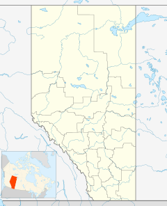
Innisfree is a small village located in central Alberta, Canada. It is found about 52 kilometers (about 32 miles) west of the town of Vermilion. You can easily find Innisfree along the Yellowhead Highway, which is a major road.
Contents
Discovering Innisfree
Innisfree is a charming village in the heart of Alberta, Canada. It's a place where a small community lives and works together. The village is known for its quiet setting and connection to the surrounding natural areas.
Where is Innisfree Located?
Innisfree is situated in the central part of the province of Alberta. It's about 52 kilometers (or 32 miles) west of a larger town called Vermilion. The village is conveniently located right beside Highway 16, also known as the Yellowhead Highway. This highway is a very important route that crosses much of Western Canada.
Who Lives in Innisfree?
The number of people living in Innisfree changes a little over time. In 2021, a count of the population showed that 187 people lived in the village. These residents lived in 94 homes. This was a small change from 2016, when 193 people lived there.
The village covers a land area of about 1 square kilometer (or 0.39 square miles). This means that in 2021, there were about 187 people living in each square kilometer of land.
In 2017, a local count showed that 223 people were living in Innisfree. Before that, in 2011, the population was 220 people.
How Innisfree is Governed
Like many villages, Innisfree has its own local government. This government is called the Innisfree Village Council. The council is led by a mayor, who helps make decisions for the community. The current mayor is Evan Raycraft. The council works to manage the village and make sure it's a good place to live for everyone.
When Was Innisfree Established?
Innisfree officially became a village on March 11, 1911. This means it has been a recognized community for over a hundred years! Over this time, it has grown and changed, but it remains a small, close-knit community in Alberta.
 | Selma Burke |
 | Pauline Powell Burns |
 | Frederick J. Brown |
 | Robert Blackburn |


