
Interstate Highways in Alaska facts for kids
   
Shields for Interstates in Alaska
|
|

Map of the Interstates of Alaska
|
|
Quick facts for kids System information |
|
|---|---|
| Formed: | 1976 |
| Length: | 1,082.22 mi (1,741.66 km) |
| Highway names | |
| Interstates: | Interstate A-n (A-n) |
| State: | Alaska Route n (AK-n) |
The Interstate Highways in Alaska are special roads that get money from the United States government. Even though they are called Interstates, most of these roads in Alaska are different from what you might see in other states.
For example, they are usually just two-lane roads. Also, they are not "grade separated." This means drivers often use regular intersections instead of special ramps to get on and off the road. You also won't see special signs for these Interstate Highways in Alaska.
These roads are important because they help people travel across Alaska. They connect major cities and towns. The government started giving money for these roads in 1976.
Alaska's Interstate Routes
There are four main Interstate Highways in Alaska. Each one connects different parts of the state:
- Interstate A1 goes from Anchorage, Alaska's largest city, all the way to the Canada border. It is about 408.23 miles (656.98 km) long.
- Interstate A2 connects Tok to Fairbanks. Fairbanks is another big city in Alaska. This route is about 202.18 miles (325.38 km) long.
- Interstate A3 runs from Anchorage to Soldotna. This road is about 148.12 miles (238.38 km) long.
- Interstate A4 travels from Palmer to Fairbanks. It is the longest of these routes, at about 323.69 miles (520.93 km) long.
Images for kids
-
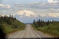
The Glenn Highway, near Glennallen, is part of Interstate A1.
-
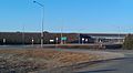
An interchange between the Richardson Highway, part of Interstate A2, and Badger Road in Fairbanks.
-
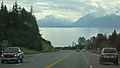
The Sterling Highway, near Homer, is part of Interstate A3.
-
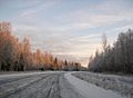
The George Parks Highway, which is all of Interstate A4.


See also
 In Spanish: Anexo:Carreteras interestatales de Alaska para niños
