
Itabashi, Tokyo facts for kids
Quick facts for kids
Itabashi
板橋
|
||
|---|---|---|
| 板橋区 · Itabashi City | ||

The east exit of Itabashi Station
|
||
|
||
| Country | Japan | |
| Region | Kantō | |
| Prefecture | Tokyo | |
| Area | ||
| • Total | 32.17 km2 (12.42 sq mi) | |
| Population
(2008)
|
||
| • Total | 531,793 | |
| • Density | 16,270/km2 (42,100/sq mi) | |
| Time zone | UTC+9 (Japan Standard Time) | |
| Postal code(s) |
173-8501
|
|
| - Tree | Keyaki | |
| - Flower | Anemone flaccida | |
| - Bird | Japanese Pied Wagtail | |
| Address | Tokyo, Itabashi-ku, Itabashi 2-66-1 173-8501 |
|

Itabashi (板橋区, Itabashi-ku) is one of the 23 special wards in Tokyo, Japan. Think of a special ward like a big neighborhood or a smaller city within the larger Tokyo area.
The local government in Itabashi calls itself "Itabashi City" in English. This helps visitors understand that it acts like its own city, even though it's part of Tokyo.
Where is Itabashi?
Itabashi is located in the northern part of Tokyo. It shares borders with other areas.
To the south, Itabashi is next to Toshima. On its western side, you'll find Nerima.
The northern border of Itabashi is marked by the Arakawa River. Across this river is Saitama Prefecture, which is another part of Japan. To the east, Itabashi borders Kita.
Symbols of Itabashi
Like many cities, Itabashi has special symbols that represent it. These symbols often show things important to the area's nature or culture.
- The official tree of Itabashi is the Keyaki tree.
- The official flower is the Anemone flaccida.
- The official bird is the Japanese Pied Wagtail.
- Itabashi also has its own flag, which is a special design that represents the ward.
Government and Leadership
Itabashi is led by a mayor. The mayor helps make important decisions for the people living in Itabashi.
As of 2008, the mayor of Itabashi was Ken Sakamoto. The city hall, where the local government works, is located at Tokyo, Itabashi-ku, Itabashi 2-66-1.
Images for kids
-
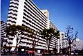
Tall apartments in Takashimadaira

See also
 In Spanish: Itabashi (Tokio) para niños
