Itapúa facts for kids
Quick facts for kids
Itapúa
|
|||
|---|---|---|---|

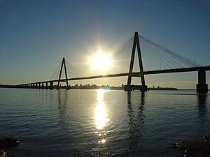
International bridge that connects Encarnación, (Paraguay) with Posadas (Argentina)
|
|||
|
|||

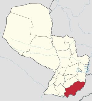
Location of Itapúa, in red, in Paraguay
|
|||
| Country | |||
| Region | Oriental | ||
| Capital | Encarnación | ||
| Districts | 30 | ||
| Area | |||
| • Total | 16,525 km2 (6,380 sq mi) | ||
| Population
(2013)
|
|||
| • Total | 551,128 | ||
| • Density | 33.3512/km2 (86.3791/sq mi) | ||
| Time zone | UTC-04 (AST) | ||
| • Summer (DST) | UTC-03 (ADT) | ||
| ISO 3166 code | PY-7 | ||
| Website | Official website: http://www.itapua.gov.py | ||
The Itapúa department (Spanish: Departamento de Itapúa) is a region in Paraguay. It's like a state or province in other countries. The main city and capital of Itapúa is Encarnación. This department is known by its special code, PY-7, which helps identify it easily.
Contents
Exploring Itapúa: Geography and Location
Itapúa is located in the southeastern part of Paraguay. It's part of the Oriental region of the country. This department covers a large area of about 16,525 square kilometers (6,380 square miles). In 2013, around 551,128 people lived here. This means there were about 33 people living in each square kilometer.
What Borders Itapúa?
Itapúa shares its borders with different areas:
- To the north: The Caazapá and Alto Paraná departments.
- To the south and east: Argentina. The Paraná river acts as a natural border here.
- To the west: The Misiones department.
 |
Caazapá | Alto Paraná |  |
|
| Misiones | Argentina | |||
| Argentina |
Rivers of Itapúa
The most important river in the Itapúa department is the Paraná river. This large river forms part of the border with Argentina.
Itapúa's Climate: Weather Patterns
The weather in Itapúa, especially in Encarnación, can vary. In 2012, the city received about 1,417 millimeters (55.8 inches) of rain. December was the wettest month, with 439 millimeters (17.3 inches) of rain. January was the driest, with only 27.3 millimeters (1.1 inches) of rain.
The average temperature in Encarnación in 2012 was 22.2°C (72°F). February was the warmest month, averaging 27.9°C (82.2°F). July was the coolest month, with an average temperature of 14.1°C (57.4°F).
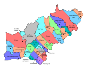
Districts of Itapúa: Local Divisions
The Itapúa department is divided into 30 smaller areas called districts. Each district has its own local government and communities.
| No. | Districts | Area (km²) |
Population (2015) |
Density |
|---|---|---|---|---|
| 1 | Alto Verá | 899.20 | 17,468 | 19.4 |
| 2 | Bella Vista | 300.01 | 13,566 | 45.2 |
| 3 | Cambyretá | 191.78 | 51,972 | 271.0 |
| 4 | Capitán Meza | 440.23 | 13,802 | 31.4 |
| 5 | Capitán Miranda | 219.15 | 13,014 | 59.4 |
| 6 | Carlos Antonio López | 821.85 | 19,734 | 24.0 |
| 7 | Carmen del Paraná | 319.88 | 8,545 | 26.7 |
| 8 | Coronel Bogado | 651.40 | 20,715 | 31.8 |
| 9 | Edelira | 633.95 | 24,320 | 38.4 |
| 10 | Encarnación | 320.32 | 127,527 | 398.1 |
| 11 | Fram | 327.84 | 9,811 | 29.9 |
| 12 | General Artigas | 1,337.67 | 12,975 | 9.7 |
| 13 | General Delgado | 456.06 | 7,894 | 17.3 |
| 14 | Hohenau | 197.03 | 14,414 | 73.2 |
| 15 | Itapúa Poty | 523.50 | 16,785 | 32.1 |
| 16 | Jesús | 143.99 | 6,339 | 44.0 |
| 17 | José Leandro Oviedo | 129.58 | 4,834 | 37.3 |
| 18 | La Paz | 239.17 | 3,333 | 13.9 |
| 19 | Mayor Otaño | 260.28 | 15,196 | 58.4 |
| 20 | Natalio | 386.03 | 21,227 | 55.0 |
| 21 | Nueva Alborada | 231.49 | 7,754 | 20.1 |
| 22 | Obligado | 412.98 | 16,281 | 39.4 |
| 23 | Pirapó | 838.34 | 8,938 | 10.7 |
| 24 | San Cosme y Damián | 1,583.43 | 9,712 | 6.1 |
| 25 | San Juan del Paraná | 103.36 | 9,410 | 91.0 |
| 26 | San Pedro del Paraná | 1,483.69 | 33,366 | 322.8 |
| 27 | San Rafael del Paraná | 1,458.79 | 22,831 | 15.7 |
| 28 | Tomás Romero Pereira | 601.70 | 29,916 | 49.7 |
| 29 | Trinidad | 176.12 | 9,340 | 53.0 |
| 30 | Yatytay | 220.74 | 13,182 | 59.7 |
More to Explore
See also
 In Spanish: Departamento de Itapúa para niños
 | Claudette Colvin |
 | Myrlie Evers-Williams |
 | Alberta Odell Jones |


