Jaune River (Saint-Charles River tributary) facts for kids
Quick facts for kids Jaune river |
|
|---|---|

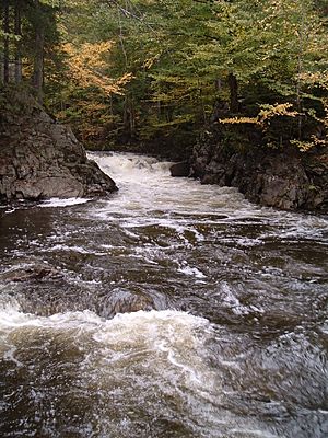
The "rivière Jaune" in Lac-Beauport
|
|
|
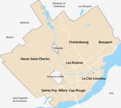
Location of the mouth of the river in Quebec City
|
|
| Native name | Rivière Jaune |
| Country | Canada |
| Province | Quebec |
| Region | Capitale-Nationale |
| Cities | Lac-Beauport and Quebec City (sector Lac-Saint-Charles |
| Physical characteristics | |
| Main source | Confluence of two mountain streams Lac-Beauport 388 m 47°02′20″N 71°15′50″W / 47.039008°N 71.263858°W |
| River mouth | Saint-Charles River Quebec (city) (sector Lac-Saint-Charles) 152 m 46°54′20″N 71°21′55″W / 46.905645°N 71.365407°W |
| Length | 26.6 km (16.5 mi) |
| Basin features | |
| River system | Saint Lawrence River |
| Basin size | 82 km2 (32 sq mi) |
| Tributaries |
|
The Jaune River (which means Yellow River in English) is a river in Quebec, Canada. It flows into the Saint-Charles River. This river is part of the Capitale-Nationale region.
The Jaune River flows through a few different places:
- The La Jacques-Cartier Regional County Municipality, including Stoneham-et-Tewkesbury and Lac-Beauport.
- Quebec City.
This river is about 26.6 kilometres (16.5 mi) long. It joins the Saint-Charles River near Lake Saint-Charles, in the Lac-Saint-Charles area of Quebec City.
The river's surface usually freezes from early December to late March. It's generally safe to walk on the ice from late December to early March. The water level changes with the seasons and how much rain falls. The biggest flood usually happens in March or April.
Contents
Where the Jaune River Flows
The Jaune River starts where two mountain streams meet. This is about 10 km north of Beauport Lake. The river then flows south through the Notre-Dame-des-Laurentides area, near Charlesbourg. Finally, it flows into the Saint-Charles River at Lac-Saint-Charles.
The River's Drainage Area
The area that collects water for the Jaune River is called its watershed. This watershed starts north of Lac-Beauport and covers about 82 square kilometres (32 sq mi). It includes smaller areas that drain into Beauport Lake and the Valet stream.
The land around the Jaune River is mostly covered by forests. Most of this area is still in its natural state. There are some small towns and villages along the river and near Beauport Lake. You can also find places for fun activities like skiing, golf, and summer camps. Many dams are also found in this area, often used for recreation.
How the River Flows
The Jaune River drops about 236 metres (774 ft) over its 26.6 kilometres (16.5 mi) journey. Here's how it flows:
- It starts by flowing 6.1 kilometres (3.8 mi) south, dropping steeply. It enters Lac-Beauport, then briefly goes into Stoneham-et-Tewkesbury. It collects water from lakes Bastien, Bonnet, and Bleu. It also flows through Lake Morin for about 0.7 kilometres (0.43 mi).
- Next, it flows 5.3 kilometres (3.3 mi) southeast. It collects water from Lake Paisible and then from Beauport Lake.
- Then, it flows 4.4 kilometres (2.7 mi) south. It collects water from Neigette and Écho lakes and passes Simons waterfall. It also gets water from an unknown stream and from Lakes Jaune and Josée.
- After that, it flows 5.5 kilometres (3.4 mi) south, winding through a wide valley. It goes through the Notre-Dame-des-Laurentides neighborhood and turns west near the Laurentian highway.
- Finally, it flows 4.4 kilometres (2.7 mi) southwest. It passes northwest of Mont Irma-LeVasseur, which is 280 metres (920 ft) high. It winds through flat urban areas and collects water from the Valet stream before reaching its mouth.
From where the Jaune River meets the Saint-Charles River, the water continues for about 32.8 kilometres (20.4 mi). It generally flows southeast, then northeast, as part of the Saint-Charles River.
Why It's Called "Yellow River"
From 1898 to 1928, the area around the Pelletier mill was known as Rivière-Jaune. The church of Notre-Dame-des-Laurentides, built in 1905, was in this spot. The community grew because of logging and wood industries.
The name "Rivière Jaune" is very old. Joseph Bouchette mentioned it in 1815. People believe the river got its name because its waters look yellow in some places. This is likely due to the sandy riverbed.
The name "rivière Jaune" was officially recognized on December 5, 1968, by the Commission de toponymie du Québec (Quebec's Place Names Commission).
 | Leon Lynch |
 | Milton P. Webster |
 | Ferdinand Smith |


