Jermyn, Pennsylvania facts for kids
Quick facts for kids
Jermyn, Pennsylvania
|
||
|---|---|---|
|
Borough
|
||

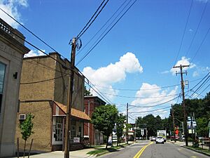
Washington Avenue in Jermyn
|
||
|
||

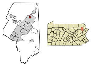
Location of Jermyn in Lackawanna County, Pennsylvania
|
||
| Country | United States | |
| State | Pennsylvania | |
| County | Lackawanna | |
| Area | ||
| • Total | 0.79 sq mi (2.05 km2) | |
| • Land | 0.79 sq mi (2.05 km2) | |
| • Water | 0.00 sq mi (0.00 km2) | |
| Elevation | 977 ft (298 m) | |
| Population
(2020)
|
||
| • Total | 2,150 | |
| • Density | 2,714.65/sq mi (1,047.64/km2) | |
| Time zone | UTC-5 (EST) | |
| • Summer (DST) | UTC-4 (EDT) | |
| ZIP code |
18433
|
|
| Area code(s) | 570 | |
| FIPS code | 42-38096 | |
Jermyn is a small town, or borough, in Lackawanna County, Pennsylvania, United States. It's often called "The Birthplace of First Aid in America." This town is located right on the Lackawanna River, about 12 miles (19 km) northeast of the city of Scranton.
Around the year 1900, Jermyn had about 2,567 people. Many moved there hoping to find jobs in the large coal mines. In those early days of the 20th century, Jermyn was busy with coal mines, factories that made cut glass, silk, and even fertilizer. There were also mills for grinding grain, sawing wood, and bottling drinks.
By the time of the 2020 census, the number of people living in Jermyn had changed to 2,156. Today, Jermyn is where the Lakeland School District has its main mailing address. A part of town east of the Lackawanna River is known by locals as "The Lane."
History of Jermyn
Jermyn was first called Gibsonburg. It was later renamed after John Jermyn, who was an important businessperson in the mining industry.
The town officially became a borough in 1870. In 1970, Jermyn celebrated its 100th birthday with a week-long party!
Geography of Jermyn
Jermyn is located at coordinates 41°31′40″N 75°32′50″W. The U.S. Census Bureau says the borough covers about 0.8 square miles (2.05 square kilometers) of land. There is no water area within the borough limits.
The Jermyn Community Center is about 977 feet (298 meters) above sea level.
Population Changes in Jermyn
| Historical population | |||
|---|---|---|---|
| Census | Pop. | %± | |
| 1880 | 1,541 | — | |
| 1890 | 2,650 | 72.0% | |
| 1900 | 2,567 | −3.1% | |
| 1910 | 3,158 | 23.0% | |
| 1920 | 3,326 | 5.3% | |
| 1930 | 3,519 | 5.8% | |
| 1940 | 3,238 | −8.0% | |
| 1950 | 2,535 | −21.7% | |
| 1960 | 2,568 | 1.3% | |
| 1970 | 2,435 | −5.2% | |
| 1980 | 2,411 | −1.0% | |
| 1990 | 2,263 | −6.1% | |
| 2000 | 2,287 | 1.1% | |
| 2010 | 2,169 | −5.2% | |
| 2020 | 2,156 | −0.6% | |
| 2021 (est.) | 2,148 | −1.0% | |
| Sources: | |||
In 2010, the census showed that 2,169 people lived in Jermyn. These people lived in 951 households, which are like homes or apartments. Out of these, 581 were families.
Most of the people in Jermyn are White. There are also smaller groups of African American, Native American, and Asian people. About 2.1% of the population identified as Hispanic or Latino.
About one-fourth of the households in Jermyn had children under 18 living there. Many households were married couples living together. Other households included single parents or individuals living alone.
The average age of people in Jermyn was 42 years old. About 20.4% of the population was under 18, and 17.9% was 65 or older.
The average yearly income for a household in Jermyn was about $32,824. For families, it was around $39,740.
See also
 In Spanish: Jermyn para niños
 | Shirley Ann Jackson |
 | Garett Morgan |
 | J. Ernest Wilkins Jr. |
 | Elijah McCoy |


