Jupitagon River facts for kids
Quick facts for kids Jupitagon River |
|
|---|---|

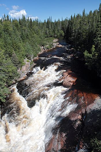
Looking upstream from Quebec Route 138
|
|
| Native name | Atshukupakatan Hipis |
| Other name(s) | Rivière Jupitagon |
| Country | Canada |
| Province | Quebec |
| Region | Côte-Nord |
| RCM | Minganie |
| Physical characteristics | |
| Main source | 366 metres (1,201 ft) |
| River mouth | Gulf of Saint Lawrence 0 metres (0 ft) 50°17′14″N 64°35′04″W / 50.2872222°N 64.5844444°W |
| Length | 49 kilometres (30 mi) |
| Basin features | |
| Basin size | 225 square kilometres (87 sq mi) |
The Jupitagon River is a beautiful river in Quebec, Canada. It's known for its salmon. It flows south from the Canadian Shield through thick forests. It finally reaches the Gulf of Saint Lawrence. Sadly, in 2018, fishing for salmon was stopped. This was because there weren't enough salmon left.
Contents
Where is the Jupitagon River Located?
The Jupitagon River flows south towards the Gulf of Saint Lawrence. It is located between two other rivers. To the east is the Magpie River. To the west is the Tonnerre River.
The river's mouth is in the town of Rivière-Saint-Jean. This area is part of the Minganie Regional County Municipality. The mouth of the river is about 12 kilometres (7.5 mi) east of the village of Rivière-au-Tonnerre.
A long time ago, at the start of the 1900s, there was a small village called Jupitagon. It was right at the river's mouth. Fishermen and their families lived there. Today, this spot is a popular place for people on vacation.
What Does the Name Jupitagon Mean?
The Innu people from Mingan have a special name for this river. They call it Atshukupakatan Hipis or Atshukukupitan Hipis. This means "little river with the sea-lion".
On an old map from 1744, the river was called Ouapitougan. Over time, its name has been spelled in different ways. Some of these spellings include Jupitagun and Chipitagun.
Some people think the name comes from the Innu language. They say ouapitagon or shusshupitagan means "river with sharpening-stones". Others believe it comes from the Cree and Atikamekw languages. In those languages, chiwitagan means "salt".
The Jupitagon River Basin
The Jupitagon River's watershed is long and narrow. It stretches about 37 kilometres (23 mi) from north to south. At its widest point downstream, it is about 12 kilometres (7.5 mi) across. This area is located between the Tonnerre River to the west and the Magpie River to the east.
The watershed covers 225 square kilometres (87 sq mi) of the Minganie Regional County Municipality. It includes parts of Lac-Jérôme, Rivière-Saint-Jean, and Rivière-au-Tonnerre.
The northern part of the watershed is on the high Canadian Shield plateau. Here, the land is steep and reaches 420 metres (1,380 ft) high. Most of the watershed is in the piedmont area, south of the plateau. This area has rounded, rocky hills. Near the coast, there's a flat plain about 8 kilometres (5.0 mi) wide. It slopes down to the Gulf of Saint Lawrence.
How the River Flows
The Jupitagon River flows for 49 kilometres (30 mi) from north to south. It drops 366 metres (1,201 ft) in height along its journey. The river is usually narrow and shallow. However, it gets wider in some spots, like at Lake Atsuk.
The river's average flow at its mouth is about 8 cubic metres per second (280 cu ft/s) (cubic meters per second). This flow can change a lot during the year. It can be as low as 2 cubic metres per second (71 cu ft/s) or as high as 20 cubic metres per second (710 cu ft/s). The Jupitagon River has two main smaller rivers that flow into it.
Many lakes are found in the watershed, covering over 8% of the area. Most of these lakes are long and narrow. Some of the larger lakes include Maloney, Belley, Panneau, Brochets, and Martre lakes.
Environment and Wildlife
The area around the Jupitagon River has a cool climate. The average temperature is about 1.1 °C (34.0 °F). It gets about 1,080 millimetres (43 in) of rain each year.
The forests here are mostly black spruce trees. Closer to the coast, black spruce forests are common. Further inland, in the hills, you'll find a mix of black spruce and balsam fir trees. In the late 1990s, many fir trees were damaged by tiny moths called hemlock loopers.
The area near the river's mouth is important for birds. It's called the Waterfowl Concentration Area of the Jupitagon River, Magpie Harbor. This protected area was set up in 1998. It helps protect many types of water birds that gather there.
Fish and Fishing in the Jupitagon River
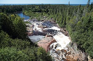
Long ago, in 1859, people said there were many salmon in the river. The lower part of the Jupitagon River is known for Atlantic salmon. However, there's a waterfall near the mouth that salmon cannot pass. This means they can't swim further upstream.
Between 1984 and 2017, the number of salmon caught in the river went down a lot. In 1990, 92 salmon were caught. But by 2012–2016, only about 4 salmon were caught each year. This decline might be partly due to rules put in place to protect the fish.
Other types of fish found in the river include:
In 2015, the government started a "catch-and-release" program for large salmon on some rivers. This meant anglers had to let big salmon go after catching them. The Jupitagon River was one of these rivers. However, some groups felt this wasn't enough to protect the salmon. They wanted stricter rules on all rivers.
Because the number of Atlantic salmon was so low, sport fishing for salmon in the Jupitagon River was completely stopped on April 1, 2018. You can still fish for other types of fish. But if you accidentally catch a salmon, you must put it back in the water right away.
 | John T. Biggers |
 | Thomas Blackshear |
 | Mark Bradford |
 | Beverly Buchanan |


