Tonnerre River (Minganie) facts for kids
Quick facts for kids Au Tonnerre River |
|
|---|---|

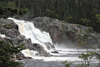
Waterfall "Grand Sault" on "Tonnerre River"
|
|
| Native name | U`suk `Sipo |
| Other name(s) | Rivière au Tonnerre |
| Country | Canada |
| Province | Quebec |
| Region | Côte-Nord |
| RCM | Minganie |
| Physical characteristics | |
| Main source | Unidentified Lake MRC Minganie Regional County Municipality, Côte-Nord, Quebec 484 m (1,588 ft) 49°26′13″N 74°03′34″W / 49.43694°N 74.05944°W |
| River mouth | Gulf of Saint Lawrence Rivière-au-Tonnerre, Quebec, MRC Minganie Regional County Municipality, Côte-Nord, Quebec 0 m (0 ft) 50°16′25″N 64°46′46″W / 50.27361°N 64.77944°W |
| Length | 85 km (53 mi) |
| Basin features | |
| Tributaries |
|
The Au Tonnerre River (which means Thunder River in English) is a river in Quebec, Canada. It flows through the town of Rivière-au-Tonnerre, Quebec. This town is part of the Minganie Regional County Municipality (RCM) in the Côte-Nord region. The river eventually flows into the Gulf of Saint Lawrence.
Contents
Where is the Au Tonnerre River Located?
The Au Tonnerre River flows south for about 85 kilometers (53 miles). It starts in a hilly area, about 6 kilometers (4 miles) west of Lake Magpie. The river has many fast-flowing sections called rapids, especially near its source.
A large waterfall, called Chute au Tonnerre (Thunder Falls), is about 30 meters (98 feet) high. It is located 5 kilometers (3 miles) upstream from where the river meets the sea. The river's mouth is in the town of Rivière-au-Tonnerre, Quebec. This spot is a natural harbor for small boats. It is about halfway between the towns of Sept-Îles and Havre-Saint-Pierre.
The town of Rivière-au-Tonnerre is built on both sides of the river's mouth. Quebec Route 138 crosses the river here. This road runs along the northern shore of the Gulf of Saint Lawrence. Another forest road, R0902, helps people reach the western part of the river's area.
The river usually freezes over from early November to the end of April. However, it's generally safe to walk or travel on the ice from late November to mid-April.
What is the Au Tonnerre River Like?
An old book from 1914, called Dictionnaire des rivières et lacs de la province de Québec, describes the river. It says the river is about 376 miles from Quebec City. You can travel by canoe for almost 40 miles from the first waterfalls. These falls are important for creating power.
About 34 miles from its mouth, there is a lake that is about 53 miles long. This lake is deep and has capes and mountains, much like the Saguenay River. It is full of pike fish. The river itself is excellent for catching salmon and trout. The land around the river is mostly sandy. A company called La Boutillier used to have a large fishing business here.
What Does the River's Name Mean?
The Innu people, who are Indigenous to the area, call the river U`suk `Sipo. This name means "red-breasted merganser." A red-breasted merganser (Mergus serrator) is a type of bird often seen on the North Shore.
On old maps, the river's name was spelled differently. For example, on maps by Jacques-Nicolas Bellin (1744) and Robert de Vaugondy (1755), it was "Ouchigouchipi." Captain Carver wrote "Ouchigoush-ipi" on his 1776 map. Another spelling used by experts was "Uhukuhîpu." The name "Thunder R." first appeared on an 1853 map by Bouchette fils. Later, on maps by Taché (1870 and 1880), it was called "R. au Tonnere."
How Big is the River's Basin?
The river basin is the area of land where all the water flows into the river. The Au Tonnerre River's basin covers about 692 square kilometers (267 square miles). It is located between the basins of two other rivers: the Sheldrake River to the west and the Jupitagon River to the east.
Part of the basin is in an area called Lac-Jérôme, which doesn't have a local government. The other part is within the municipality of Rivière-au-Tonnerre. Maps of Quebec's natural regions show that the river basin is in areas known for spruce trees and moss.
 | Tommie Smith |
 | Simone Manuel |
 | Shani Davis |
 | Simone Biles |
 | Alice Coachman |


