
Kalangadoo, South Australia facts for kids
Quick facts for kids KalangadooSouth Australia |
|||||||||||||||
|---|---|---|---|---|---|---|---|---|---|---|---|---|---|---|---|

Kalangadoo Hotel
|
|||||||||||||||

Kalangadoo
Location in South Australia
|
|||||||||||||||
| Established | 1891 (town) 13 December 2001 (locality) |
||||||||||||||
| Postcode(s) | 5278 | ||||||||||||||
| Time zone | ACST (UTC+9:30) | ||||||||||||||
| • Summer (DST) | ACDT (UTC+10:30) | ||||||||||||||
| Location |
|
||||||||||||||
| LGA(s) | Wattle Range Council | ||||||||||||||
| Region | Limestone Coast | ||||||||||||||
| County | Grey | ||||||||||||||
| State electorate(s) | MacKillop | ||||||||||||||
| Federal Division(s) | Barker | ||||||||||||||
|
|||||||||||||||
|
|||||||||||||||
| Footnotes | Adjoining localities Locations |
||||||||||||||
Kalangadoo, once called Kalangadoo East, is a small town in South Australia. It's about 348 kilometers (216 miles) south-east of Adelaide, the state's capital. It's also about 31 kilometers (19 miles) north of Mount Gambier, a bigger town nearby.
History of Kalangadoo
The town of Kalangadoo was first officially named Kalangadoo East in 1891. The name comes from an Aboriginal word. It means "big trees in water."
The town grew because of the Mount Gambier railway line. This railway line connected Naracoorte and Mount Gambier. It opened in 1887, and Kalangadoo had its own railway station.
The town became busy after the narrow gauge railway arrived in 1887. A public school was built in 1892. The railway station building itself was finished in 1907.
In 1940, the town's name was changed to Kalangadoo. However, after World War II, the town became quieter. Farmers started using their cars to shop in bigger towns like Penola and Mount Gambier.
The public school was very popular in 1966, with 150 students. But by 1991, only 74 students attended.
The railway station closed in 1985. Trains still used the tracks, but they didn't stop at Kalangadoo. The station building was empty until 1999. A local timber mill bought it to sell wood products. The railway line stopped carrying freight in 1995. Tourist trains, run by the Limestone Coast Railway, continued until 2006.
In 2016, a company called Shield Formply bought the old timber mill. They planned to update the mill and create new jobs. The idea was to use local blue gum and pine trees. These would be made into wood veneer and sent to other countries.
Kalangadoo has a community club. It's the home ground for several sports teams. These include the Kalangadoo Football Club, Netball Club, Cricket Club, and Bowls Club. In 2021, the club's facilities were updated.
About Kalangadoo Today
Kalangadoo is in an area known for farming. Farmers here grow potatoes and timber. They also have apple orchards, beef cattle, sheep, and dairy cattle. The town's small business area has a general store, a farm supply store, a pub, and a timber mill.
In 2016, a count of people (called a census) showed that 288 people lived in the Kalangadoo area.
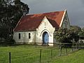
The Anglican Church of St Alban the Martyr is the only church that holds regular services. The Catholic church, built in 1904, is not used very often. The Presbyterian church, which opened in 1914, is now a bed and breakfast. The building that used to be the Uniting Church (opened 1906, closed 2007) is now used for a weekly farmers' market.
As of 2022, Kalangadoo Primary School had 27 students. They were taught in two classes.
The old railway station building now has a small museum. It was created in 2011 by Peter Savage. He used to be the stationmaster and loves trains. He has collected many items about the station from all over Australia.
The historic Kalangadoo House is located off the Kalangadoo-Nangwarry Road. It is listed on the South Australian Heritage Register, which means it's an important historical place.
How Kalangadoo is Governed
Kalangadoo is part of different government areas.
- For national elections, it's in the federal division of Barker.
- For state elections, it's in the state electoral district of MacKillop.
- For local services, it's part of the Wattle Range Council.
Images for kids
-
Saint Andrews Presbyterian Church, Kalangadoo

